 Global Information
Tuolumne River information
| Tuolumne River | |
|---|---|
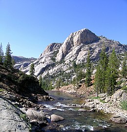 The Tuolumne River at Glen Aulin valley, below Tuolumne Meadows | |
 The Tuolumne River watershed | |
| Location | |
| Country | United States |
| State | California |
| Physical characteristics | |
| Source | Confluence of Lyell and Dana Forks |
| • location | Tuolumne Meadows, Yosemite National Park |
| • coordinates | 37°52′31″N 119°21′08″W / 37.87528°N 119.35222°W[1] |
| • elevation | 8,589 ft (2,618 m) |
| Mouth | San Joaquin River |
• location | Grayson, Stanislaus County |
• coordinates | 37°36′21″N 121°10′25″W / 37.60583°N 121.17361°W[1] |
• elevation | 26 ft (7.9 m) |
| Length | 148.7 mi (239.3 km) |
| Basin size | 1,958 sq mi (5,070 km2)[2] |
| Discharge | |
| • location | above La Grange Dam[3] |
| • average | 2,343 cu ft/s (66.3 m3/s)[3] |
| • minimum | 57 cu ft/s (1.6 m3/s) |
| • maximum | 130,000 cu ft/s (3,700 m3/s) |
| Basin features | |
| Tributaries | |
| • left | South Fork Tuolumne River |
| • right | Cherry Creek, Clavey River, North Fork Tuolumne River |
National Wild and Scenic River | |
| Type | Wild, Scenic, Recreational |
| Designated | September 28, 1984 |
The Tuolumne River /tuˈɒləmi/ (Yokutsan: Tawalimnu)[4] flows for 149 miles (240 km) through Central California, from the high Sierra Nevada to join the San Joaquin River in the Central Valley. Originating at over 8,000 feet (2,400 m) above sea level in Yosemite National Park, the Tuolumne drains a rugged watershed of 1,958 square miles (5,070 km2), carving a series of canyons through the western slope of the Sierra. While the upper Tuolumne is a fast-flowing mountain stream, the lower river crosses a broad, fertile and extensively cultivated alluvial plain. Like most other central California rivers, the Tuolumne is dammed multiple times for irrigation and the generation of hydroelectricity.
Humans have inhabited the Tuolumne River area for up to 10,000 years. Prior to the arrival of Europeans, the river canyon provided an important summer hunting ground and a trade route between Native Americans in the Central Valley to the west and the Great Basin to the east. First named in 1806 by a Spanish explorer after a nearby indigenous village, the Tuolumne was heavily prospected during the California Gold Rush in the 1850s, and the lower valley was cultivated by American settlers over the next few decades. The city of Modesto grew up on the Tuolumne as a railroad hub, absorbing most of the population of the Tuolumne valley around the turn of the century. As agricultural production rose, farmers along the Tuolumne formed California's first two irrigation districts to better control and develop the river.
From the 1900s to the 1930s, the river was dammed at Don Pedro and Hetch Hetchy to provide water for Central Valley farmers and the city of San Francisco, respectively. The Hetch Hetchy project, located inside Yosemite National Park, incited national controversy, and has been described as having forged the modern environmental movement in the United States.[5] As the mid-20th century progressed, demands on the Tuolumne continued to increase, culminating in the completion of New Don Pedro Dam in the early 1970s. These projects halved the amount of water flowing from the Tuolumne into the San Joaquin, greatly reducing the once-abundant runs of salmon and steelhead in both rivers.
- ^ a b "Tuolumne River". Geographic Names Information System. United States Geological Survey, United States Department of the Interior. January 19, 1981. Retrieved September 13, 2014.
- ^ "Chapter 5.3 Tuolumne River System and Downstream Water Bodies". Preliminary Environmental Impact Report on SFPUC Water System Improvement Program. City & County of San Francisco Planning Department. 2005. Retrieved March 21, 2015.
- ^ a b "USGS Gage #11288000 on the Tuolumne River above La Grange Dam near La Grange, CA". National Water Information System. U.S. Geological Survey. 1911–1970. Retrieved September 13, 2014.
- ^ Swanton, J.R. (1952). The Indian Tribes of North America. Bulletin (Smithsonian Institution. Bureau of American Ethnology). Genealogical Publishing Company. p. 505. ISBN 978-0-8063-1730-4.
- ^ "A Century Later, the Battle for Hetch Hetchy Continues". Earth Island Institute. Retrieved October 12, 2015.