This article is about the beck which flows into Windermere. For the tributary of the Glenderamackin, see Trout Beck (Glenderamackin).
Trout Beck
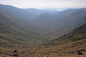
Trout Beck from Thresthwaite Mouth
Trout Beck, highlighted in orange, in OpenStreetMap
Location
Country
England
County
Cumbria
Villages
Troutbeck, Troutbeck Bridge
Physical characteristics
Source
Stony Cove Pike
• location
Cumbria
• elevation
1,970 ft (600 m)
Mouth
Windermere
• location
Calgarth, Cumbria
• elevation
128 ft (39 m)
Length
8.3 mi (13.4 km)
The Trout Beck is a fast flowing stream of the Lake District in North West England. It is one of the main sources of replenishment for Windermere, and is part of the Leven catchment.[1] Its name comes from Old Norse and appears in documents from 1292 as Trutebyk. The river rises between the peaks of Stony Cove Pike and Thornthwaite Crag in the High Street range, at a height of about 1,970 feet (600 m).
Several tributaries flowing from the crags to the west of the High Street Roman road combine to form the young Trout Beck. The river descends rapidly, more or less in a southerly direction, through Troutbeck Park and to the west of Troutbeck Tongue. At a height of about 650 feet (200 m) the Woundale Beck, draining the eastern flanks of Broad End and Pike How, is subsumed. The engorged Trout Beck then skirts Hird Wood on its eastern side before subsuming Hagg Gill at the 460 feet (140 m) contour. This latter tributary drains the fells around the course of the old Roman road.
The river passes under Ing Bridge as it continues in a southerly direction down the Troutbeck valley through the tranquil fields of the valley bottom. The hamlets of Town Head and High Green are just to the west of the river as it enters Limefitt Park. On emerging from Limefitt the river is bridged by the A592 Kirkstone Pass road. Troutbeck village lies on the west side of the valley. Continuing through a narrow area of mixed woodland the river eventually reaches the A591 road at Troutbeck Bridge near the town of Windermere. After less than a mile (2 km) the river enters Windermere on its eastern shore at a point close to Calgarth Hall.
From its source the Trout Beck descends some 1,840 feet (560 m) in a distance of about seven miles (11 km). The river is a trout fishery where brown trout can be caught. Anglers should enquire locally about licences (an Environment Agency Rod Licence is required).
The Trout Beck is wholly within the historic county of Westmorland, and since 1974, has also been in the administrative county of Cumbria.
^"Trout Beck". Catchment Data Explorer. Environment Agency. Retrieved 18 April 2016.
The TroutBeck is a fast flowing stream of the Lake District in North West England. It is one of the main sources of replenishment for Windermere, and...
River Leven. It is replenished by the rivers Brathay, Rothay, TroutBeck, Cunsey Beck and several other lesser streams. The lake is largely surrounded...
area. Troutbeck Bridge takes its name from where the road crosses the TroutBeck. The community is served by a petrol station and convenience store, an...
Windermere, west bank; drains Esthwaite Water) Black Beck (enters head of Esthwaite Water) TroutBeck (L) (enters Windermere, east bank) River Brathay (combines...
released when caught. Whilst the beck has had a natural population of sea trout, up to 84,000 were released into the beck in 2015 to replenish stocks after...
and the TroutBeck joins it at Wolt Bridge to the south of Lowside. Not too far away it is soon swelled again by the waters of Mosedale Beck next to Dobson's...
Lakeland TroutBeck, a Cumbrian 'beck' in whose valley lies Troutbeck, South Lakeland Troutbeck Tongue, a mountain in Cumbria above TroutBeck Troutbeck...
portal River Brathay River Rothay TroutBeck River Leven Fletcher, Joe (23 June 2022). "'Disaster' as pollution strikes beck in Lake District". The Westmorland...
the south of the main top a short spur juts out into the head of the TroutBeck valley, before falling steeps over Doup Crag. From the lower top the narrow...
Similarly, Groove Beck, which rises on Matterdale Common, the north-east ridge of Great Dodd, becomes Thornsgill Beck and then TroutBeck, before joining...
and a parish in East Ward district, Westmoreland. The township lies on Troutbeck, an affluent of the river Eden, 1½ mile ESE of Kirkby-Thore r. station...
Cumbria portal Cunsey Beck River Leven TroutBeck Hodges, Maureen (12 December 2021). "Restoration project sees Great Langdale Beck reconnected to Elterwater"...
south-westward from the main Ill Bell ridge, just north of Froswick. It separates TroutBeck from Hagg Gill, its main upper tributary. These two streams almost reconverge...
located 5.4 miles (8.7 km) by road east of the city centre of Carlisle. The TroutBeck stream passes here. The village forms part of a small urban area which...
northwards before ascending Orrest Head, dropping down again to cross TroutBeck then taking to the high fell tops, visiting Wansfell Pike the highest...
Commons has media related to River Rothay. Cumbria portal Cunsey Beck River Leven TroutBeck Rotha Clay "Rothay Water Body". Catchment Data Explorer. Department...
milling.[citation needed] A trout farm was established beside the beck in 1971 as the cold, clean water was ideal for raising trout. The business built a lake...
to its mouth at Middlesbrough. Slate Sike Swath Beck Crooked Beck Rake Sike Fallcrag Sike TroutBeck Tynegreen Sike Great Dodgen Pot Sike Crook Burn Smithy...
brown trout (Salmo trutta), and grayling (Thymallus thymallus). In addition to these there are also considerable numbers of stocked brown trout and stocked...
wedge of high ground pushes out into the Troutbeck valley. Separating TroutBeck from its main tributary Hagg Gill, is the modest height of Troutbeck Tongue...
Cock Beck is a stream in the outlying areas of East Leeds, West Yorkshire, England, which runs from its source due to a runoff north-west of Whinmoor,...
Heritage List for England, retrieved 28 May 2017 Historic England, "Wynlass Beck, Windermere (1096097)", National Heritage List for England, retrieved 19...
 Global Information