 Global Information
Transit map information
This article needs additional citations for verification. (April 2014) |
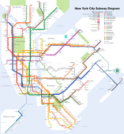

A transit map is a topological map in the form of a schematic diagram used to illustrate the routes and stations within a public transport system—whether this be bus, tram, rapid transit, commuter rail or ferry routes. Metro maps, subway maps, or tube maps of metropolitan railways are some common examples.
The primary function of a transit map is to facilitating the passengers' orientation and navigation, helping them to efficiently use the public transport system and identify which stations function as interchange between lines.
Unlike conventional maps, transit maps are usually not designed to be geographically accurate. Instead, to increase legibility, simplicity and visual aesthetic quality, designers simplify complex routes by using abstract geometry - straight lines, fixed angles and often a fixed distance between stations, compressing those in the outer area of the system and expanding those close to the center. This transformation of a topographical map into a schematic diagram is known as schematization. Although they prioritize clarity over strict geographic accuracy, the relative positions and connections between stations and routes are still accurately depicted for effective navigation. Transit map design places a strong emphasis on user needs, ensuring that layouts and visual elements are optimized to empower passengers with intuitive navigation tools, facilitating seamless decision-making and enhancing overall travel experience.
The main components of a transit map include symbols or named icons representing stations, stops, and interchanges, color-coded lines indicating available routes and transportation services, capturing not only the essential structure of transport networks, but also the city's iconic landscape itself. Its layout, such as geographic, multilinear, radial, concentric circular, grid, or hybrid, is chosen based on geographical intricacies, network complexity, and user preference. Careful consideration is given to icon choice to distinguish different kinds of stations (regular, interchange or terminal), line styles, colors, typography, and their consistent application for clear, effective and intuitive communication.
Transit maps can be found in the transit vehicles, at the platforms or in printed timetables. They are also accessible through digital platforms like mobile apps and websites, ensuring widespread availability and convenience for passengers.
Cite error: There are <ref group=lower-alpha> tags or {{efn}} templates on this page, but the references will not show without a {{reflist|group=lower-alpha}} template or {{notelist}} template (see the help page).