Global Information Lookup Global Information

Topographic Atlas of Switzerland information


Siegfried Map of the Türlersee region in the Canton of Zürich
Siegfried Map of the Aletsch Glacier region (1882; Lithography by Rudolf Leuzinger). It is interesting to compare the size of the Märjelensee and the extent of the glaciers with current data.

The Topographic Atlas of Switzerland (German: Topographischer Atlas der Schweiz), also known as the Siegfried Atlas or Siegfried Map (German: Siegfriedkarte; French: Carte Siegfried) is an official map series of Switzerland. Its publication was begun by the Federal Topographic Bureau under Hermann Siegfried [de], and continued from 1870 to 1926.[1] During this period the individual maps were drawn by different lithographers, including Walter Hauenstein, Georg Christian von Hoven and Rudolf Leuzinger. Since it is, in today's parlance, not strictly an atlas but a map series, map historians now describe it only by the expression Siegfried Map.

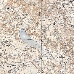
The Siegfried Map was based on the original records that had already been created for the earlier Dufour Map. However, the Siegfried Map offered greater precision than the Dufour Map, by using a scale of 1:25,000 for the Swiss plateau, the French Prealps, the Jura Mountains and southern Ticino, and a scale of 1:50,000 for other mountain regions and the Swiss Alps.

The area covered by the former scale was initially divided into 462 pages, and the other area into 142 pages, with the two areas overlapping in places. A format of 35 centimetres (14 in) x 24 centimetres (9.4 in) for each page was common to both scales.

Another significant departure from the Dufour Map was the presence of contours to symbolize the relief (a granularity of 10 metres (33 ft) for the 1:25 000 pages, and 30 metres (98 ft) for the 1:50 000 pages). In addition, three colors were used directly for printing, whereas the Dufour Map was initially monochrome. On the Siegfried Map, the colours used were brown for the contour lines on vegetated terrain, blue for water and contour lines on glaciers, and black for the rest.

The Siegfried Map projection was a cone equivalent, as for the Dufour Map.

The print mode used for the 1:25,000 pages was initially intaglio, and from 1905 a printing plate. The 1:50,000 pages were printed via a lithography process, and from 1910 by intaglio.

Until 1949, there were occasional revised editions of Siegfried Map pages. From 1952, the Siegfried and Dufour Maps were replaced by the new National Map of Switzerland.

  1. ^ "Background information on the Siegfried Map". Federal Office of Topography swisstopo. Retrieved 2020-09-08.

and 23 Related for: Topographic Atlas of Switzerland information

Request time (Page generated in 1.1042 seconds.)

Topographic Atlas of Switzerland

Last Update:

The Topographic Atlas of Switzerland (German: Topographischer Atlas der Schweiz), also known as the Siegfried Atlas or Siegfried Map (German: Siegfriedkarte;...

Word Count : 423

Topographic Map of Switzerland

Last Update:

The Topographic Map of Switzerland (German: Topographische Karte der Schweiz), also known as the Dufour Map (German: Dufourkarte; French: Carte Dufour)...

Word Count : 509

Cartography of Switzerland

Last Update:

1869 to 1901, this map was replaced by the Topographic Atlas of Switzerland (German: Topographischer Atlas der Schweiz) or Siegfried Map (German: Siegfriedkarte;...

Word Count : 1944

List of highest mountains of Switzerland

Last Update:

a list of the highest mountains of Switzerland. This list only includes summits above 3,600 metres (11,811 ft) with a topographic prominence of at least...

Word Count : 466

Switzerland

Last Update:

to the east. Switzerland is geographically divided among the Swiss Plateau, the Alps and the Jura; the Alps occupy the greater part of the territory...

Word Count : 20260

Rudolf Leuzinger

Last Update:

new Topographic Atlas of Switzerland, Siegfried commissioned Leuzinger to do the difficult engravings of the mountains – based on the original maps of Dufour...

Word Count : 726

List of mountain peaks by prominence

Last Update:

explanations of topographic prominence, key col, and parent, see topographic prominence. In particular, the different definitions of the parent of a peak are...

Word Count : 703

Unteraargletscher

Last Update:

de l'Aar (1844) (Neuchâtel Public and University Library, cote: BPUN Q 820 A) Unteraargletscher in the Topographic Atlas of Switzerland 1870–1922 v t e...

Word Count : 225

List of prominent mountains of Switzerland

Last Update:

sortable table of many of the major mountains and hills of Switzerland. The table only includes those summits that have a topographic prominence of at least...

Word Count : 1275

List of historical maps

Last Update:

Geological Survey, National Program for Topographic Mapping (1884) War of the Rebellion Atlas (1895) Maps of the United Kingdom The Brittania (John Ogilby...

Word Count : 372

Romandy

Last Update:

cultural region part of Switzerland. In 2020, about 2 million people, or 22.8% of the Swiss population, lived in Romandy. The majority of the romand population...

Word Count : 1625

Julier Pass

Last Update:

close proximity of the Julier Pass List of highest paved roads in Switzerland List of highest road passes in Switzerland Topographic map of the Grisons,...

Word Count : 244

Outline of Switzerland

Last Update:

Population of Switzerland: 8,606,000 (2019) - 99th most populous country Area of Switzerland: 41,285 km2 Atlas of Switzerland Environment of Switzerland Environmental...

Word Count : 1316

List of submarine topographical features

Last Update:

This is a list of submarine topographical features, oceanic landforms and topographic elements. An abyssal plain is an underwater plain on the deep ocean...

Word Count : 3893

Map series

Last Update:

named Topographic Atlases, because their small-sized sheets were also bound into atlases. An example of such a map series is the Topographic Atlas of the...

Word Count : 2087

Grisons

Last Update:

Retrieved 16 March 2021. Topographic map of the Grisons, Swisstopo. Retrieved 8 March 2021 Summits of Switzerland, Federal Office of Topography. Retrieved...

Word Count : 6436

Swiss Alps

Last Update:

Alps[permanent dead link] MySwissAlps.com WalkingSwitzerland.com Maps Map of Switzerland with points of interest Topographic maps of Switzerland Other General information...

Word Count : 3643

Cartography

Last Update:

topographic map is primarily concerned with the topographic description of a place, including (especially in the 20th and 21st centuries) the use of contour...

Word Count : 7299

Lake Geneva

Last Update:

254 1:25,000 topographic map (Map). Swisstopo. Retrieved 27 July 2014. Cuckoo, Paul (26 October 2007). "Switzerland mastering the art of wine making"...

Word Count : 2823

Doldenhorn

Last Update:

Swisstopo topographic maps. The key col is the Fründenjoch (2,983 m) Retrieved from Google Earth. The nearest point of higher elevation is west of the Blüemlisalp...

Word Count : 69

Piz Gloria

Last Update:

Given the difficult topographic and climatic conditions, parts had to be prefabricated. The outer skin of the circular upper floor is of aluminium-clad wooden...

Word Count : 451

Lake Thun

Last Update:

Oberland in Switzerland named after the city of Thun, on its northern shore. At 48.3 km2 (18.6 sq mi) in surface area, it is the largest Swiss lake entirely...

Word Count : 403

Dunantspitze

Last Update:

Grenzgipfel on Siegfried Map. max 1:50 000. "Topographical Atlas of Switzerland (Siegfried Map 1:50 000)". Bern, Switzerland: Eidg. Stabsbureau. § "535 Zermatt"...

Word Count : 852

PDF Search Engine © AllGlobal.net