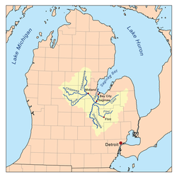
The Tittabawassee River (/ˈtɪtəbəˈwɑːsi/TIH-tə-bə-WAH-see) flows in a generally southeasterly direction through the Lower Peninsula of the U.S. state of Michigan. The river begins at Secord Lake in Clement Township, at the confluence of the East Branch and the Middle Branch.[3] From there it flows through Gladwin, Midland and Saginaw counties where, as a major tributary of the Saginaw River, it flows into it at Saginaw. Its tributaries include the Chippewa, Pine, Molasses, Sugar, and Tobacco rivers.
Significant communities on or near the Tittabawassee River include Saginaw, Midland, and Sanford. At Edenville, the river was impounded by the hydroelectric Edenville Dam to create Wixom Lake. It was also impounded by a hydroelectric dam in Sanford to create Sanford Lake prior to the dam failures and resulting flooding on May 19, 2020. In Saginaw County, the river flows through Tittabawassee Township, which is named for the river and contains the unincorporated community of Freeland.
The main river is 72.4 miles (116.5 km) long[3] and drains an area of 2,471 square miles (6,400 km2).[4]
^"Tittabawassee River". Geographic Names Information System. United States Geological Survey, United States Department of the Interior.
^United States Environmental Protection Agency. "Watershed Report: Tittabawassee River". WATERS GeoViewer. Archived from the original on July 5, 2021. Retrieved July 5, 2021.
^ abUnited States Geological Survey. "National Hydrography Dataset high-resolution flowline data". The National Map. Retrieved November 7, 2011.
^"Tittabawassee River Assessment" (PDF). Michigan Department of Natural Resources.
and 15 Related for: Tittabawassee River information
The TittabawasseeRiver (/ˈtɪtəbəˈwɑːsi/ TIH-tə-bə-WAH-see) flows in a generally southeasterly direction through the Lower Peninsula of the U.S. state...
Saginaw River is a 22.4-mile-long (36.0 km) river in the U.S. state of Michigan. It is formed by the confluence of the Tittabawassee and Shiawassee rivers southwest...
(180 km) from its source to its confluence with the TittabawasseeRiver creating the Saginaw River, which drains into Saginaw Bay of Lake Huron. The name...
failure of the dam in May 2020. It was formed by the damming of the TittabawasseeRiver near the village of Sanford, Michigan. It was built for flood control...
to establish a Superfund to address dioxin cleanup of the TittabawasseeRiver, Saginaw River and Saginaw Bay. In December 2015, Dow Chemicals agreed to...
was an earthen embankment dam at the confluence of the TittabawasseeRiver and the Tobacco River in Mid Michigan, United States, forming Wixom Lake. The...
Tamarack River Tawas River Thornapple River Thunder Bay River Tioga RiverTittabawasseeRiver Tobacco River (Keweenaw County, Michigan) Tobacco River (Tittabawassee...
Narrative for Metamora Landfill". Retrieved December 4, 2009. "TITTABAWASSEERIVER, SAGINAW RIVER & BAY site profile". Retrieved February 22, 2019. US EPA,...
River may refer to: Sugar River (Michigan), a tributary of the TittabawasseeRiver Sugar River (New Hampshire), a tributary of the Connecticut River Sugar...
River, City of Crystal Falls Edenville Dam, Lake Wixom on TittabawasseeRiver, Gladwin County, Hydro Power Edison Sault Power Canal, St. Marys River (Michigan–Ontario)...
includes many rivers including the Grand River, Red Cedar River, Saginaw River, TittabawasseeRiver, Shiawassee River and Flint River. A drainage divide...
February 15, 2020 River Rouge looks at plans beyond power plant, Joshua J. Paladino, The Detroit News, January 15, 2017 DTE Retires River Rouge Coal-Fired...
Cass Rivers flow into the Shiawassee River in the refuge. Here also the Shiawassee converges with the TittabawasseeRiver to form the Saginaw River. Refuge...
Tobacco River is a 10.5-mile-long (16.9 km) river in Gladwin County, Michigan, in the United States. It is a tributary of the TittabawasseeRiver, which...
Molasses River is a 16.8-mile-long (27.0 km) river in Gladwin County, Michigan, in the United States. It is a tributary of the TittabawasseeRiver, part...
 Global Information