 Global Information
Tilouthu information
This article needs additional citations for verification. (September 2007) |
Tilouthu | |
|---|---|
town | |
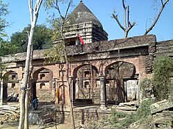 Ancient Radhe Krishna Temple (Akhada Temple) | |
 | |
 Location in Bihar, India | |
| Coordinates: 24°48′18″N 84°05′00″E / 24.80505°N 84.08331°E[1] | |
| Country | |
| State | Bihar |
| District | Rohtas |
| Division | Patna |
| Area [2] | |
| • Total | 9.583 km2 (3.700 sq mi) |
| Elevation [1] | 119 m (390 ft) |
| Population (2011)[2] | |
| • Total | 16,402 |
| • Density | 1,700/km2 (4,400/sq mi) |
| Languages | |
| • Official | Hindi and Urdu |
| • Common | Bhojpuri |
| Time zone | UTC+5:30 (IST) |
| PIN | 821312 |
| Nearest city | Dehri |
| Literacy | 95% |
| Lok Sabha constituency | Sasaram |
| Vidhan Sabha constituency | Sasaram |
| Website | rohtas |
Tilothu, also spelled Tilauthu or Tilothu, is a village and corresponding community development block in Rohtas district, Bihar, India. It is located 15 km from Dehri-on-Sone on the west bank of the Son River. As of 2011, the population of Tilouthu was 16,402, in 2,745 families, while the corresponding block population was 109,249.[2]
The census town of Saraiya is located within Tilouthu block, immediately south of the village of Tilouthu. Kaimur pahari stands erect in the west of the city whereas the river Sone blesses the farmers with its water in the east.
Tilothu cattle fair is considered to be the largest cattle fair in the state.[citation needed] This town is well connected by road to an important junction Dehri-on-Sone. This city is very popular among nearby villages as a place of worship of Lord Shiva.[citation needed]
It may be developed as a tourist place. A waterfall is located at the far end of this small city. It has religious importance i.e. one of Maa Shakti's forms in form of a cave is located alongside the waterfall. The waterfall is a hot spot of picnic for people from the near villages. The negligence attitude and the fear of naxalites hinders the required exposure to this place.[citation needed]
- ^ a b "Geonames.org. Tiloth". Retrieved 8 June 2020.
- ^ a b c "Census of India 2011: Bihar District Census Handbook - Rohtas, Part A (Village and Town Directory)". Census 2011 India. pp. 33, 44–70, 1124-, 1191–1192. Retrieved 8 June 2020.