7 prefectures 74 counties 699 towns and subdistricts
Government
• Type
Autonomous region
• Body
Tibet Autonomous Region People's Congress
• CCP Secretary
Wang Junzheng
• Congress Chairman
Losang Jamcan
• Government Chairman
Yan Jinhai
• Regional CPPCC Chairman
Pagbalha Geleg Namgyai
• National People's Congress Representation
24 deputies
Area
[1]
• Total
1,228,400 km2 (474,300 sq mi)
• Rank
2nd
Highest elevation
(Mount Everest)
8,848 m (29,029 ft)
Population
(2020[2])
• Total
3,648,100
• Rank
32nd
• Density
3.0/km2 (7.7/sq mi)
• Rank
33rd
Demographics
• Ethnic composition
86.0% Tibetan
12.2% Han 0.8% others
• Languages and dialects
Tibetan, Mandarin Chinese
GDP[3]
• Total
CN¥ 213 billion US$ 32 billion
• Per capita
CN¥ 58,438 US$ 8,688
ISO 3166 code
CN-XZ
HDI (2021)
0.614[4] (31st) – medium
Website
www.xizang.gov.cn(in Chinese)
Tibet
"Tibet" in Chinese (top) and Tibetan (bottom)
Chinese name
Chinese
西藏
Hanyu Pinyin
Xīzàng
Literal meaning
"Western Tsang"
Transcriptions
Standard Mandarin
Hanyu Pinyin
Xīzàng
Bopomofo
ㄒㄧ ㄗㄤˋ
Gwoyeu Romatzyh
Shitzanq
Wade–Giles
Hsi1-tsang4
Tongyong Pinyin
Sizàng
Yale Romanization
Syīdzàng
IPA
[ɕí.tsâŋ]
other Mandarin
Xiao'erjing
ثِزَانْ
Wu
Romanization
Si平zaon去
Hakka
Romanization
Sî-tshông
Yue: Cantonese
Yale Romanization
Sāi-johng
Jyutping
sai1 zong6
IPA
[sɐi˥ tsɔːŋ˨]
Southern Min
Hokkien POJ
Se-chōng
Teochew Peng'im
Sai-tsăng
Eastern Min
Fuzhou BUC
Să̤-câung
Tibet Autonomous Region
Simplified Chinese
西藏自治区
Traditional Chinese
西藏自治區
Hanyu Pinyin
Xīzàng Zìzhìqū
Transcriptions
Standard Mandarin
Hanyu Pinyin
Xīzàng Zìzhìqū
Bopomofo
ㄒㄧ ㄗㄤˋ
ㄗˋ ㄓˋ ㄑㄩ
Gwoyeu Romatzyh
Shitzanq Tzyhjyhchiu
Wade–Giles
Hsi1-tsang4 Tzu4-chih4-chʻü1
Tongyong Pinyin
Sizàng Zìhjhìhcyu
Yale Romanization
Syīdzàng Dz̀jr̀chyū
IPA
[ɕí.tsâŋ tsɹ̩̂.ʈʂɻ̩̂.tɕʰý]
other Mandarin
Xiao'erjing
ثِزَانْ زِجِکِیُوِ
Wu
Romanization
Si平zaon去 Zy去zy去chiu平
Hakka
Romanization
Sî-tshông Tshṳ-tshṳ-khî
Yue: Cantonese
Jyutping
sai1 zong6 zi6 zi6 keoi1
IPA
[sɐi˥ tsɔːŋ˨ tsiː˨ tsiː˨ kʰɵy˥]
Southern Min
Hokkien POJ
Se-chōng Chū-tī-khu
Teochew Peng'im
Sai-tsăng Tsĕu-tī-khu
Eastern Min
Fuzhou BUC
Să̤-câung Cê̤ṳ-dê-kṳ̆
Tibetan name
Tibetan
བོད་
Transcriptions
Wylie
bod
Tibetan Pinyin
Poi
Lhasa IPA
[pʰø̀ʔ]
Manchu name
Manchu script
ᠸᠠᡵᡤᡳ ᡩᡯᠠᠩ
Romanization
wargi Dzang
Mongolian name
Mongolian
ᠲᠢᠪᠧᠲ Tibyet
This article contains Tibetan script. Without proper rendering support, you may see very small fonts, misplaced vowels or missing conjuncts instead of Tibetan characters.
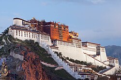
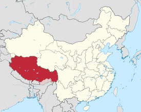
The Tibet Autonomous Region, officially the Xizang Autonomous Region, often shortened to Tibet or Xizang,[note 1] is an autonomous region of China and is part of Southwestern China.
It was formally established in 1965 to replace the Tibet Area, the former administrative division of the PRC established after the annexation of Tibet. The establishment was about five years after the 1959 Tibetan uprising and the dismissal of the Kashag, and about 13 years after the original annexation.
The current borders of the Tibet Autonomous Region were generally established in the 18th century[6] and include about half of historical Tibet. The Tibet Autonomous Region spans over 1,200,000 km2 (460,000 sq mi), and is the second-largest province-level division of China by area, after Xinjiang. Due to its harsh and rugged terrain, it is sparsely populated at just over 3.6 million people with a population density of 3 inhabitants per square kilometre (7.8/sq mi).
^西藏概况(2007年) [Overview of Tibet (2007)] (in Chinese). People's Government of Tibet Autonomous Region. 11 September 2008. Archived from the original on 22 December 2015. Retrieved 18 December 2015.
^"Communiqué of the Seventh National Population Census (No. 3)". National Bureau of Statistics of China. 11 May 2021. Retrieved 11 May 2021.
^"National Data". National Bureau of Statistics of China. 1 March 2022. Retrieved 23 March 2022.
^"Human Development Indices (5.0)- China". Global Data Lab. Retrieved 11 January 2023.
^Wong, Chun Han (5 January 2024). "China Doesn't Want You to Say 'Tibet' Anymore". Wall Street Journal. New York City. Retrieved 6 January 2024.
^"What is Tibet? – Fact and Fancy", Excerpt from Goldstein, Melvyn, C. (1994). Change, Conflict and Continuity among a Community of Nomadic Pastoralist: A Case Study from Western Tibet, 1950–1990. pp. 76–87.{{cite book}}: CS1 maint: multiple names: authors list (link)
Cite error: There are <ref group=note> tags on this page, but the references will not show without a {{reflist|group=note}} template (see the help page).
and 24 Related for: Tibet Autonomous Region information
characters. The TibetAutonomousRegion, officially the Xizang AutonomousRegion, often shortened to Tibet or Xizang, is an autonomousregion of China and...
District of Lhasa City, is the inner urban district of Lhasa City, TibetAutonomousRegion, Southwestern China. Lhasa is the second most populous urban area...
Ningxia were made autonomous in 1958. Tibet was annexed by the People's Republic of China in 1951, and was declared an autonomousregion in 1965. The designation...
Chinese control of the territory now known as the TibetAutonomousRegion or Xizang AutonomousRegion, and others arguing that the ultimate goal on the...
areas inhabited by ethnic Tibetans) is mostly comprised in the TibetAutonomousRegion (TAR) of China and partly in the Chinese provinces of Qinghai and...
This is a list of prisons within TibetAutonomousRegion province of the People's Republic of China. This list does not include detention centres, which...
recognise the McMahon Line and claims that the area is a part of the TibetAutonomousRegion instead. According to Hsiao-ting Lin, a scholar from Taiwan, and...
India. A smaller number resides in the western regions of the TibetAutonomousRegion and were partially relocated for the establishment of the Changtang...
by India but administered by China. Xinjiang also borders the TibetAutonomousRegion and the provinces of Gansu and Qinghai. The most well-known route...
Tibetan areas of China, including the TibetAutonomousRegion and the surrounding Tibetan-designated autonomous areas. The efforts are undertaken by China...
Lhasa, TibetAutonomousRegion, and operates scheduled domestic flights out of Lhasa Gonggar Airport and Chengdu Shuangliu International Airport. Tibet Airlines...
public university in Lhasa, Tibet, China. It is affiliated with the TibetAutonomousRegion and co-funded by the regional government and the Ministry of Education...
stream of the Brahmaputra River located in the TibetAutonomousRegion, China. It is the longest river of Tibet and the fifth longest in China. The upper section...
compassion. Pronunciation: Common English names: Tibet; or Xizang Official English names: Xizang AutonomousRegion of the People's Republic of China Common endonym(s):...
Sanskrit: कैलास, IAST: Kailāsa) is a mountain in Ngari Prefecture, TibetAutonomousRegion of China. It lies in the Kailash Range (Gangdisê Mountains) of...
Panchen Lama's release. The Panchen Lama was born in Lhari County, TibetAutonomousRegion, from where he was kidnapped under the authority of the People's...
changed the land ownership and taxation systems. Since 1981, the TibetAutonomousRegion government no longer permits new polyandric marriages under family...
 Global Information