Global Information Lookup Global Information

Thiruvananthapuram district information


Thiruvananthapuram district
Trivandrum district
District of Kerala
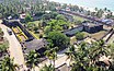
Clockwise from top:
Niyamasabha Mandiram, Kovalam Beach, Attingal, Poovar beach, Varkala underpass, and Anchuthengu Fort.
Location in Kerala
Location in Kerala
Map
Thiruvananthapuram district
Coordinates: 8°29′N 76°56′E / 8.48°N 76.94°E / 8.48; 76.94
CountryIndia
StateKerala
HeadquartersThiruvananthapuram
Subdistricts
  • Thiruvananthapuram
  • Varkala
  • Neyyattinkara
  • Nedumangadu
  • Chirayinkeezhu
  • Kattakada
Government
 • Lok Sabha constituencies2
Area
 • Total2,192 km2 (846 sq mi)
 • Rank11th
Population
 (2021)
 • Total3,521,153 (male: 1,767,859; female: 1,753,294; transgender: 500)
 • Urban
55.75%
Demographics
 • Literacy93.02%[1]
Languages
 • OfficialMalayalam ,English[2]
 • Regional
  • Malayalam - 98.25%
  • Tamil - 1.18%
  • Others - 0.57%[3]
Vehicle registrationKL-01 Thiruvanthapuram,
KL-15 KSRTC,
KL-16 Attingal,
KL-19 Parassala,
KL-20 Neyyattinkara,
KL-21 Nedumangad,
KL-22 Kazhakoottam,
KL-74 Kattakkada,
KL-81 Varkala
Major highwaysNH 66, NH 866
HDI (2005)Increase 0.773[4] ( High)
Average annual precipitation1,700 mm
Thiruvananthapuram district is located in India
Thiruvananthapuram district
class=notpageimage|
Thiruvananthapuram District's location on map of India

Thiruvananthapuram District (IPA: [t̪iɾuʋɐnɐn̪d̪ɐpuɾɐm] ) is the southernmost district in the Indian state of Kerala. The district was created in 1949, with its headquarters in the city of Thiruvananthapuram, which is also Kerala's administrative centre. The present district was created in 1956 by separating the four southernmost Taluks of the erstwhile district to form Kanyakumari district. The city of Thiruvananthapuram is also known as the Information technology capital of the State, since it is home to the first and largest IT park in India, Technopark, established in 1990. The district is home to more than 9% of total population of the state.[5]

The district covers an area of 2,192 square kilometres (541,655 acres). At the 2011 census, it had a population of 3,301,427,[6][7] making it the second most populous district in Kerala after Malappuram district.[8] Its population density is the highest in Kerala, with 1,509 inhabitants per square kilometre (3,910/sq mi).[9] The district is divided into six subdistricts: Thiruvananthapuram, Chirayinkeezhu, Neyyattinkara, Nedumangadu, Varkala, and Kattakada. The urban bodies in the district are the Thiruvananthapuram Corporation, and the Varkala, Neyyattinkara, Attingal, and Nedumangad municipalities.[10]

Thiruvananthapuram district is located between 8°10′N 76°25′E / 8.17°N 76.41°E / 8.17; 76.41 and 8°32′N 77°10′E / 8.54°N 77.17°E / 8.54; 77.17. At the southernmost extremity of the district, Kaliyikkavila is 54 kilometres (34 mi) from Kanyakumari, the southernmost point on the Indian peninsula.[11] 33.75% of the district population lives in urban areas.[12]

The district has three major rivers, several freshwater lakes, and over 300 ponds. Its eastern region is forested, northern regions are mostly under rubber cultivation and the remaining areas grow mixed dry-land crops of coconut, plantain, and tapioca, among others. Built-up areas and rice fields complete the land use pattern.[13]

  1. ^ Directorate of Census Operations, Kerala. District Census Handbook, Thiruvananthapuram (PDF). Directorate of Census Operations, Kerala. p. 22. Retrieved 25 June 2020.
  2. ^ "The Kerala Official Language (Legislation) Act, 1969" (PDF).
  3. ^ "Table C-16 Population by Mother Tongue: Kerala". www.censusindia.gov.in. Registrar General and Census Commissioner of India.
  4. ^ "Kerala | UNDP in India". UNDP.
  5. ^ "Population profile of Kerala - 2011". State Planning Board, Kerala. Government of Kerala. Retrieved 21 October 2020.
  6. ^ "About District | Website of Thiruvananthapuram District - The city of the Holy Anantha | India". Retrieved 10 July 2021.
  7. ^ "CENSUS OF INDIA 2011" (PDF). PROVISIONAL POPULATION TOTALS INDIA, KERALA STATE AND DISTRICTS. Government of India. Retrieved 24 April 2011.
  8. ^ "District Census Hand Book: Thiruvananthapuram" (PDF). Census of India. Registrar General and Census Commissioner of India.
  9. ^ "CENSUS OF INDIA 2011" (PDF). Provisional Population Totals Kerala. Government of India. p. 45. Retrieved 24 April 2011.
  10. ^ "Districts Thiruvananthapuram". indiastudychannel. Retrieved 21 July 2010.
  11. ^ "A Brief History" (PDF). District Handbooks of Kerala: Thiruvananthapuram. Government of Kerala. Retrieved 18 March 2015.
  12. ^ "TVM Urbanaisation". censusindia. Archived from the original on 11 January 2010.
  13. ^ "Keralapages.org". keralapages.org. Retrieved 19 March 2018.

and 24 Related for: Thiruvananthapuram district information

Request time (Page generated in 0.8461 seconds.)

Thiruvananthapuram district

Last Update:

Thiruvananthapuram District (IPA: [t̪iɾuʋɐnɐn̪d̪ɐpuɾɐm] ) is the southernmost district in the Indian state of Kerala. The district was created in 1949...

Word Count : 5029

Thiruvananthapuram

Last Update:

Thiruvananthapuram, commonly shortened to TVM or by its former name Trivandrum, is the capital city of the Indian state of Kerala. It is the most populous...

Word Count : 11238

Thiruvananthapuram Lok Sabha constituency

Last Update:

in Kerala, India. It is located in Thiruvananthapuram district and encompasses the major part of Thiruvananthapuram city, the capital of Kerala State....

Word Count : 591

List of colleges in Thiruvananthapuram

Last Update:

Thiruvananthapuram (Trivandrum) is the capital city of Kerala, India. The city has the most number of schools, higher educational institutions, professional...

Word Count : 487

List of revenue divisions of Kerala

Last Update:

Karunagappally Punalur RDO: Punalur, Pathanapuram, Kottarakkara Thiruvananthapuram RDO: Thiruvananthapuram, Chirayinkeezhu (HQ: Attingal), Varkala, Neyyattinkara...

Word Count : 257

Thiruvananthapuram Assembly constituency

Last Update:

registered voters in the constituency for the 2011 election. Thiruvananthapuram Thiruvananthapuram district List of constituencies of the Kerala Legislative Assembly...

Word Count : 244

Kanyakumari district

Last Update:

the eight tehsils of Thiruvananthapuram district were separated from the erstwhile Travancore Kingdom to form the new district of Kanniyakumari, and...

Word Count : 5067

Administration of Thiruvanathapuram district

Last Update:

are located in Thiruvananthapuram. The city also serves as the headquarters of the Thiruvananthapuram district. The Thiruvananthapuram municipality was...

Word Count : 1060

Ishaani Krishna

Last Update:

Ishaani Krishna is an Indian model, YouTuber and actress who appears primarily in Malayalam films. She made her cinematic debut in the Malayalam movie...

Word Count : 56

List of schools in Thiruvananthapuram district

Last Update:

Thiruvananthapuram district in Kerala, India has a variety of schools affiliated to State education board, Central Board of Secondary Education (CBSE)...

Word Count : 214

Thiruvananthapuram District Football Association

Last Update:

Thiruvananthapuram District Football Association (TDFA) is the organization responsible for association football in and around the Indian city of Thiruvananthapuram...

Word Count : 135

Vizhinjam International Seaport Thiruvananthapuram

Last Update:

The Vizhinjam International Seaport Thiruvananthapuram (IPA:vɪzɪnˈdʒam ˌɪntərˈnæʃənl ˈsiːpɔːt ˌtɪrʊvənənˈtɑːpʊrəm ,VIZH-in-jam in-ter-NASH-uh-nuhl SEE-port...

Word Count : 4051

Geography of Thiruvananthapuram

Last Update:

The Indian city of Thiruvananthapuram is located in Thiruvananthapuram district in the state of Kerala. The city is located at 8°30′N 76°54′E / 8.5°N...

Word Count : 1148

Thiruvananthapuram Taluk

Last Update:

Thiruvananthapuram Taluk is a Taluk (tehsil) in Thiruvananthapuram district in the Indian state of Kerala. It is the most populous taluk in the district...

Word Count : 137

Thiruvananthapuram railway division

Last Update:

Thiruvananthapuram Railway Division (TVC) or Trivandrum Railway Division(TVC) is one of the six administrative divisions of the Southern Railway, Indian...

Word Count : 567

Thiruvananthapuram International Airport

Last Update:

Thiruvananthapuram International Airport (IATA: TRV, ICAO: VOTV), is an international airport that serves Thiruvananthapuram, the capital city of Kerala...

Word Count : 2653

Pulluvila

Last Update:

Pulluvila is a village between Kovalam and Poovar in Thiruvananthapuram district of Kerala state, India. It is hardly 7 km (4.3 mi) away from the proposed...

Word Count : 712

Agastya Mala

Last Update:

Agastyarkoodam) is one of the peaks in the Western Ghats of Thiruvananthapuram District of Kerala, near to the border of Tamilnadu, India. This peak...

Word Count : 1076

Nedumangad

Last Update:

Nedumangad is a municipal town in the Thiruvananthapuram district in the Indian state of Kerala. It is the headquarters of Nedumangad Tehsil and Nedumangad...

Word Count : 1716

Thiruvananthapuram Central railway station

Last Update:

Thiruvananthapuram Central (station code: TVC, also known as Trivandrum Central) is an NSG–2 category railway station in Thiruvananthapuram railway division...

Word Count : 778

Varkala Beach

Last Update:

is situated in the town of Varkala in Varkala Municipality, Thiruvananthapuram district, Kerala, India. The beach skirts the Arabian Sea, part of the...

Word Count : 300

Hill Highway

Last Update:

Kasaragod district to Parassala in Thiruvananthapuram district, at a length of 1332.16 km. The highway will pass through 13 of the 14 districts, the exception...

Word Count : 1407

List of airports in Kerala

Last Update:

Shankumugham in state capital of Thiruvananthapuram district Cochin International Airport in Nedumbassery in Ernakulam district Kozhikode International Airport...

Word Count : 333

List of RTO districts in Kerala

Last Update:

Manjeswar AE KL-15 Registered in Thiruvananthapuram for KSRTC 1989 Thiruvananthapuram A KL-16 Attingal in Thiruvananthapuram District 2002 Chirayinkeezhu AB KL-17...

Word Count : 293

PDF Search Engine © AllGlobal.net