Extent of the Tenasserim Hills and their subranges
Countries
Myanmar, Thailand and Malaysia
Parent range
Indo-Malayan System
Borders on
Dawna Range, Shan Hills, Thai highlands
Geology
Age of rock
Permian and Triassic
Type of rock
Granite and Limestone
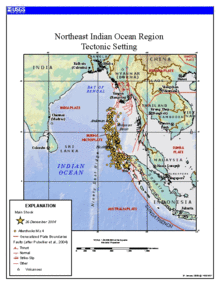
The Khao Sok mountains, Surat Thani, Thailand, towards the southern end of the Tenasserim RangeUnnamed Lesser Peak of Mount Tahan in the highest area of the range, Pahang State, MalaysiaLimestone hills near Wat Nong Hoi, Ratchaburi, ThailandThe Tenasserim Hills in Kapong, Phang Nga, ThailandKhao Nom Nang, a breast-shaped hill in Kanchanaburi ProvinceMap of the tectonic setting of the 2004 Indian Ocean earthquake showing the fault lines across the Tenasserim HillsThe Tenasserim Hills as represented in an old 19th century map by Aristide Michel Perrot
The Tenasserim Hills or Tenasserim Range (Burmese: တနင်္သာရီ တောင်တန်း, [tənɪ̀ɰ̃θàjìtàʊɰ̃dáɰ̃]; Thai: ทิวเขาตะนาวศรี, RTGS: Thio Khao Tanao Si, pronounced[tʰīwkʰǎwtā.nāːwsǐː]; Malay: Banjaran Tanah Seri/Banjaran Tenang Sari) is the geographical name of a roughly 1,700 km long mountain chain, part of the Indo-Malayan mountain system[1] in Southeast Asia.
Despite their relatively scant altitude these mountains form an effective barrier between Thailand and Myanmar in their northern and central region.[2] There are only two main transnational roads and cross-border points between Kanchanaburi and Tak, at the Three Pagodas Pass and at Mae Sot. The latter is located beyond the northern end of the range, where the Tenasserim Hills meet the Dawna Range. Minor cross-border points are Sing Khon,[3] near Prachuap Khiri Khan, as well as Bong Ti and Phu Nam Ron west of Kanchanaburi. The latter is expected to gain in importance if the planned Dawei Port Project goes ahead, along with a highway and a railway line between Bangkok and that harbor.[4]
The southern section of this extensive chain of mountains runs along the Kra Isthmus into the Malay Peninsula almost reaching Singapore. Many rivers have their source in these mountains, but none of them are very long.
Tanintharyi Region in Myanmar (Burma) Tenasserim town, a former name of Tanintharyi TenasserimHills or Tenasserim Range, part of the Indo-Malayan mountain...
to the Kra Isthmus. It borders the Andaman Sea to the west and the TenasserimHills, beyond which lie Thailand, to the east. To the north is the Mon State...
Thailand's largest freshwater marsh. The limestone hills are a sub-range of the TenasserimHills that arise at the shore of the Gulf of Thailand, with...
the TenasserimHills, extending further northwards for over 400 km (250 mi) beyond the Three Pagodas Pass. The Kra Isthmus is in the Tenasserim-South...
port. There area seven national parks in the mountainous areas of the TenasserimHills, along with two other national parks, make up region 3 (Ban Pong) of...
following the TenasserimHills. This narrow region stretches from Bangkok's outer reaches to the border with Myanmar and from the Shan Hills in the north...
200 ft), with the Dawna Range in the west reaching the beginning of the TenasserimHills further south. Doi Inthanon, the highest point in Thailand, reaching...
and Thailand. It is named after the Tenasserim Hills. Phylogenetic evidence indicates that the Tenasserim lutung is an ancestor of the far more widespread...
Khao Sok National Park (Thai: เขาสก, pronounced [kʰǎw sòk]) is in Surat Thani Province, Thailand. Its area is 461,712 rai ~ 739 square kilometres (285 sq mi)...
and an equatorial climate. Situated at the southern foothills of the TenasserimHills, inselbergs and massifs dominate the state's flat landscape, with Mount...
Ong, Thai pronunciation: [dàːn tɕeːdiː sǎːm ʔoŋ]) is a pass in the TenasserimHills on the border between Thailand and Myanmar (Burma), at an elevation...
kilometres (50 mi) west of Bangkok and borders Myanmar to the west with the TenasserimHills as a natural border. The Mae Klong flows through the centre of Ratchaburi...
state's highlands are part of the Nakawan Range, a subrange of the TenasserimHills system that spans through southern Myanmar, Southern Thailand and Peninsular...
00 km2). Southeastern Hills Myanmar's Southeastern Hills and see the Tenasserim Plains have western shores backed by the Tenasserim Range respectively....
identified only relatively recently. It lives in the TenasserimHills, in the upper Great Tenasserim River drainage area. It was named after Thai aquarist...
ranges belong to the Titiwangsa Mountains, a southern subrange of the TenasserimHills that spans throughout southern Myanmar, southern Thailand and Peninsular...
northern end of the TenasserimHills further south and southeast. The Dawna Range extends east of the Salween southwards from the Shan Hills for about 350 km...
District in Terengganu. The mountain is part of the Tahan Range in the TenasserimHills and is popular with local climbers. Gunung Tahan is considered by many...
from northeast Thailand (Isan) by the Phetchabun mountain range. The TenasserimHills separate it from Myanmar to the west. In the north it is bounded by...
Pinus latteri, or Tenasserim pine, is a pine native to Mainland Southeast Asia. Pinus latteri is a medium-sized to large tree, reaching 25–45 metres (82–148...
sa.wàt]), is a river in western Thailand. It has its source in the TenasserimHills and flows for about 380 kilometres (240 mi) through Sangkhla Buri,...
head of the TenasserimHills, so that frequently the whole mountainous area is considered as a whole under the name "Kayah-Karen/Tenasserim". They are...
mountain ranges belong to the Titiwangsa Mountains, which are part of the TenasserimHills that span throughout southern Myanmar, southern Thailand and Peninsular...
 Global Information