 Global Information
Tematagi information
 NASA picture of Tematagi Atoll | |
 Tematagi | |
| Geography | |
|---|---|
| Location | Pacific Ocean |
| Coordinates | 21°40′S 140°37′W / 21.667°S 140.617°W |
| Archipelago | Tuamotus |
| Area | 61 km2 (24 sq mi) (lagoon) 7.7 km2 (3.0 sq mi) (above water) |
| Length | 11.5 km (7.15 mi) |
| Width | 7 km (4.3 mi) |
| Administration | |
France | |
| Overseas collectivity | French Polynesia |
| Administrative subdivision | Tuamotus |
| Commune | Tureia |
| Demographics | |
| Population | 58[1] (2012) |
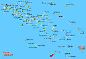
Tematagi or Tematangi[2] is an atoll in the southeastern area of the Tuamotu Archipelago, French Polynesia. Tematagi's nearest neighbour is Mururoa, which is located 161 kilometres (100 miles) to the ESE.
Tematagi is a medium-sized atoll. It measures approximately 11.5 kilometres (7.1 miles) in length and has a maximum width of 7 kilometres (4.3 miles) with a land area of almost 8 square kilometres (3.1 square miles). As its reef completely encloses the deep lagoon, which is 61 square kilometres (24 square miles), there is no navigable pass to enter the lagoon.
There are many relatively large islands on Tematagi's reef, as well as a few small motu. The main village is Tuihana. There were 58 inhabitants on Tematagi in the last census.
- ^ "Population". Institut de la statistique de la Polynésie française. Retrieved 9 October 2014.
- ^ Board of Geographical Names Site Internet: http://geonames.usgs.gov/foreign/index.html