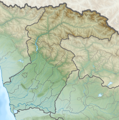
The Tekhuri (Georgian: ტეხური)[1] is a right tributary of the river Rioni in Georgia.
The Tekhuri rises in the Egrisi Range below the 3002 m high summit Tekhurishdudi. It flows through the region Samegrelo-Zemo Svaneti in a predominantly south-south-west direction. In the middle course it flows past the place Salkhino near Martvili. Finally it reaches the Colchian Plain, flows southeast of the city Senaki and turns south. Shortly afterwards the Abasha meets the Tekhuri from the left. After another 10 km the Tekhuri flows into the Rioni. It is 101 km (63 mi) long, and has a drainage basin of 1,040 km2 (400 sq mi).[2]
^T'ekhuri Geonames.org
^Statistical Yearbook of Georgia: 2020, National Statistics Office of Georgia, Tbilisi, 2020, p. 12.
The Tekhuri (Georgian: ტეხური) is a right tributary of the river Rioni in Georgia. The Tekhuri rises in the Egrisi Range below the 3002 m high summit Tekhurishdudi...
(left), Qvirila (left), Khanistsqali (left), Tskhenistsqali (right) and Tekhuri (right). Stephanus of Byzantium wrote that there was also another river...
Senaki municipality, Samegrelo-Zemo Svaneti region, Georgia. Located by the Tekhuri River, on the northern edge of the Colchian plain in Samegrelo, western...
northeast from 60 to 170 meters. The highest place, the headwaters of Tekhuri is located at 3003 meters above sea level. To the south-west of the municipality...
narrower sense, Odishi referred to a tract of land between the Inguri and Tekhuri rivers, bathed by the Black Sea. The chief town and largest settlement...
3–5 m (9.8–16.4 ft) range. In the center of the Range near the head of the Tekhuri river at an elevation of 1600 meters is the Lebarde balneological resort...
covering most of what is now the Martvili Municipality, traversed by the Tekhuri River, on the border with Imereti. Both the title of Lipartiani and the...
 Global Information