Tasman Lake is a proglacial lake formed by the recent retreat of the Tasman Glacier in New Zealand's South Island.[5]
In the early 1970s, there were several small meltwater ponds on the Tasman Glacier. By 1990, these ponds had merged into Tasman Lake.[6]
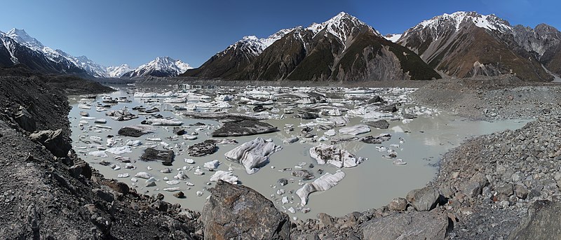
Tour boat among the icebergs on Tasman Lake
Tasman Lake has quickened the retreat of the Tasman Glacier. Initially it did so by undercutting the cliff at the end of the glacier, causing parts of the cliff to fall into the lake. Since 2006, however, a 50–60 m (160–200 ft) apron of submerged glacial ice projects out from the cliff, and icebergs periodically break off the apron and float away down the lake. Because more of the glacier is now in contact with the water, its rate of retreat has increased. By 2008 the lake was about 7 km (4 mi) long, 2 km (1 mi) wide and 245 m (800 ft) deep, having almost doubled in area since 2000.[7] It is expected to grow to a maximum length of about 16 km (9.9 mi) within the next one or two decades.[8]
Tasman Lake, the glacier and the surrounding mountains are part of Aoraki / Mount Cook National Park. Taking a boat tour among the icebergs on the Tasman Lake is now a popular tourist activity.[9] For safety reasons the small inflatable boats are not allowed closer than 1.5 km (0.9 mi) to the 50 m (160 ft) tall terminal face of Tasman Glacier.[10] Tasman Lake can be reached by road from the nearby Mount Cook Village and a short walk from the car park at the end of the road.
Like many other geographic places in both New Zealand and Australia, it is named after Dutch explorer Abel Janszoon Tasman.
Tasman Lake viewed from near its outlet (right), in spring 2010
^Sahiban Kanwal (13 January 2015). "University of Canterbury researchers use hi-tech jetboat to research Tasman Glacier". Stuff. The Timaru Herald. Retrieved 2016-09-14.
^"Tasman Lake, Canterbury". NZ Topo Map. Land Information New Zealand. Retrieved 2016-09-14.
^Charles R. Warren & Martin P. Kirkbride (1998). Temperature and bathymetry of ice-contact lakes in Mount Cook National Park, New Zealand - New Zealand Journal of Geology and Geophysics. Vol. 41. Royal Society of New Zealand. pp. 133–143.
^"Place name detail: Tasman Lake". New Zealand Gazetteer. New Zealand Geographic Board. Retrieved 18 April 2008.
^Hochstein, M.P.; Claridge, D.; Henrys, S.A.; Pyne, A.; Nobes, D.C. and Leary, S.F. (1995). Downwasting of the Tasman Glacier, South Island, New Zealand: changes in the terminus region between 1971 and 1993 Archived 2008-10-22 at the Wayback Machine, New Zealand Journal of Geology and Geophysics 38 (1), 1-16.
^Dykes, Robert C.; Brook, Martin S.; Winkler, Stefan (2010). "The contemporary retreat of Tasman Glacier, Southern Alps, New Zealand, and the evolution of Tasman proglacial Lake since AD 2000". Erdkunde. 64 (2): 147–148. doi:10.3112/erdkunde.2010.02.03. Archived from the original on 17 March 2022. Retrieved 4 December 2015.
TasmanLake is a proglacial lake formed by the recent retreat of the Tasman Glacier in New Zealand's South Island. In the early 1970s, there were several...
the Tasman Glacier and fell into the TasmanLake. Boats were hit with tsunami waves of up to 3.5 metres (11 ft) as the ice fell into the TasmanLake under...
Island Tasman (settlement), a settlement in Tasman District Tasman River, flowing from TasmanLake and contributed to by other glacial rivers Tasman Fracture...
as: The Tasman Peninsula. The Tasman Bridge. The Tasman Highway. The Tasman Sea. In New Zealand: The Tasman Glacier. TasmanLake. The Tasman River. Mount...
Mount Cook National Park, where it is the outflow of the proglacial TasmanLake. It is also fed by the glacial waters of the tributary Murchison River...
Tasmania, when the bulk carrier Lake Illawarra, travelling up the Derwent River, collided with several pylons of the Tasman Bridge and caused a large section...
The Tasman Bridge is a prestressed concrete girder bridge connecting the Tasman Highway over the River Derwent in Hobart, Tasmania, Australia. When it...
of the Samodivski Lakes, Pirin Mountain, Bulgaria TasmanLake, New Zealand Lake Kaniere in the West Coast region of New Zealand Lake Gopło in the Cuyavia...
Tasman District (Māori: Te Tai o Aorere) is a local government district in the northwest of the South Island of New Zealand. It borders the Canterbury...
easy walking track circles the lake, which is famous for its reflected views of Aoraki / Mount Cook and Mount Tasman. Lake Matheson formed between two moraine...
Lake Rotoroa (Māori: "long lake") may refer to the following New Zealand lakes: Lake Rotoroa (Northland) Lake Rotoroa (Tasman) Lake Rotoroa (Hamilton...
Lake Illawarra was a handysize bulk carrier of 7,274 tons in the service of the Australian National Line. This ship is known for causing the Tasman Bridge...
Lake Rotoiti is the name of two lakes in New Zealand: Lake Rotoiti (Bay of Plenty), in the North Island Lake Rotoiti (Tasman), in the South Island Rotoiti...
30 million tonnes (33 million ST) of ice tumbled off the glacier into TasmanLake, hitting tour boats with tsunami waves 3.5 metres (11 ft) high. KiwiRail...
the lake, but they do the large, nearby TasmanLake. Climate change in New Zealand Wikimedia Commons has media related to Hooker Lake. "Hooker Lake, Canterbury...
(West Coast), a lake in the West Coast region, South Island Lake Rotoroa (Tasman), formerly known as Lake Arthur United States Lake Arthur, Louisiana...
Region. The following lakes are located in the Tasman Region. The following lakes are located in the Nelson Region. The following lakes are located in the...
are possible wherever large bodies of water are found, including inland lakes, where they can be caused by landslides and glacier calving. Very small...
745 ft) above sea level. The lake is fed at its northern end by the braided Tasman River, which has its source in the Tasman and Hooker Glaciers, close...
Island. It is bordered to the north by Cook Strait, to the west by the Tasman Sea, and to the south and east by the Pacific Ocean. The South Island covers...
 Global Information