This article is about the bay on the north coast of New Zealand's South Island. For the bay on the east coast of Manawatāwhi / Great Island, see Manawatāwhi / Three Kings Islands.
This article needs additional citations for verification. Please help improve this article by adding citations to reliable sources. Unsourced material may be challenged and removed. Find sources: "Tasman Bay" – news · newspapers · books · scholar · JSTOR(November 2015) (Learn how and when to remove this message)
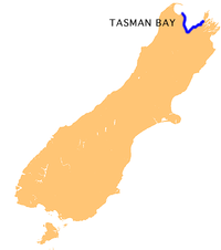
Tasman Bay (Māori: Te Tai-o-Aorere; officially Tasman Bay / Te Tai-o-Aorere), originally known in English as Blind Bay, is a large V-shaped bay at the north end of New Zealand's South Island. Located in the centre of the island's northern coast, it stretches along 120 kilometres (75 mi) of coastline and is 70 kilometres (43 mi) across at its widest point. It is an arm of the Tasman Sea, lying on the western approach to Cook Strait.
At the bay's western extremity, the land around the bay is rough and densely forested. Separation Point, the westernmost point of the bay, is located in Abel Tasman National Park and separates Tasman Bay from its smaller neighbour, Golden Bay. To the east, the land is also steep, with the westernmost points of sea-drowned valleys of the Marlborough Sounds. D'Urville Island sits to the northeast of Tasman Bay's easternmost point. Arrow Rock is situated off the coast of Nelson.
The land between these two extremes is more gently rolling, and also includes the coastal plains around the mouth of the Waimea River at the bay's southernmost point. Other rivers entering the sea along the coast of the bay include the Riwaka, the Motueka and Maitai Rivers. The long low form of Rabbit Island is located close to the bay's south coast. Tasman Bay contains the rare rock formation known as the Boulder Bank.
The fertile land around the centre of the bay's coast is extensively cultivated and known for its horticultural crops such as apples, kiwifruit, olives, grapes and hops. In the middle of the twentieth century the Tasman Bay area produced large crops of tobacco. There is a tobacco museum in Motueka. It is also the most densely populated part of the South Island's north coast, and several towns and the city of Nelson are all located close to the shore. These towns include Riwaka, Motueka, Māpua and Richmond.
TasmanBay (Māori: Te Tai-o-Aorere; officially TasmanBay / Te Tai-o-Aorere), originally known in English as Blind Bay, is a large V-shaped bay at the...
River. Mount Tasman. The Abel Tasman National Park. TasmanBay. The Tasman District. Abel Tasman Monument. Also named after Tasman are: Tasman Pulp and Paper...
the Tasman District Council, a unitary authority, which sits at Richmond, with community boards serving outlying communities in Motueka and Golden Bay /...
Tasman National Park is a national park at the north end of New Zealand's South Island. It covers 237.1 km2 (91.5 sq mi) of land between Golden Bay /...
up Tasman in Wiktionary, the free dictionary. Tasman most often refers to Abel Tasman (1603–1659), Dutch explorer. Tasman may also refer to: Tasman booby...
the north by Norfolk Bay, to the northwest by Frederick Henry Bay, to the west and south by Storm Bay, and to the east by the Tasman Sea. Many smaller towns...
The Tasman Rugby Union is the governing body for rugby union in TasmanBay / Te Tai-o-Aorere, a bay at the north end of the South Island in New Zealand...
the park, the other being the Abel Tasman Inland Track, which stretches for 38 km between Tinline Bay and Torrent Bay off the main coastal track. The coastal...
Rākauroa / Torrent Bay is a bay in Abel Tasman National Park, New Zealand. Torrent Bay was named by French explorer Dumont D'Urville during his exploration...
Ruby Bay is a settlement in the Tasman District of New Zealand's upper South Island. It is located between Māpua and Tasman on Te Mamaku / Ruby Bay. Ruby...
Island. It is bordered to the north by Cook Strait, to the west by the Tasman Sea, and to the south and east by the Pacific Ocean. The South Island covers...
sunset on the water" for Rotokura. The bay itself is a 600 metres (2,000 ft) wide, northwest-facing bay in the TasmanBay / Te Tai-o-Aorere. It lies just north...
mouth at the Tasman Sea, midpoint between the suburbs of La Perouse and Kurnell. The northern headland of the entrance to the bay from the Tasman Sea is Cape...
Bay, Oahu Waimea Canyon State Park, Kauai Waimea Ditch, Kauai Waimea River (Kauai) Waimea River (Oahu) Waimea Valley, Oahu Waimea Inlet, TasmanBay Waimea...
the Tasman Region of New Zealand's South Island. It flows east to reach Torrent Bay on the TasmanBay / Te Tai-o-Aorere coast of the Abel Tasman National...
helped it recover, and catches in the 1990s were up to 684 tonnes. The TasmanBay area was closed to commercial scallop harvesting from 2009 to 2011 due...
northwest of New Zealand's South Island. It flows for 20 kilometres, entering TasmanBay close to the town of Riwaka, 10 kilometres north of Motueka. The valleys...
Awaroa Bay Awaroa Inlet is a remote, alluring body of water within the Abel Tasman National Park, at the northern end of TasmanBay, in the Tasman Region...
Nations Cup. Ioane has previously played for clubs such as Stade Français, Tasman, Bay of Plenty, and Benetton. On 22 August 2023, he was named in the Italy's...
1960 and 1961. Anderson conducted a survey of archaeological sites in TasmanBay for his Masters degree in geography from the University of Canterbury...
mouth of the Motueka River on the western shore of TasmanBay. It is the second largest in the Tasman Region, with a population of 8,320 as of June 2023...
Tokangawhā / Split Apple Rock is a geological rock formation in TasmanBay / Te Tai-o-Aorere off the northern coast of the South Island of New Zealand...
The Tasman Sea is a marginal sea of the South Pacific Ocean, situated between Australia and New Zealand. It measures about 2,000 km (1,200 mi) across and...
 Global Information