Global Information Lookup Global Information

Talladega National Forest information


Talladega National Forest
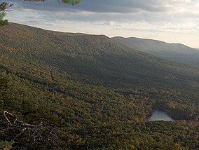
Cheaha Mountain, Alabama's highest point, is located in Talladega National Forest.
Map showing the location of Talladega National Forest
LocationAlabama, U.S.
Nearest cityTalladega, AL
Coordinates33°11′46″N 86°27′45″W / 33.19611°N 86.46250°W / 33.19611; -86.46250
Area392,567 acres (1,588.66 km2)
EstablishedJuly 17, 1936[1]
Governing bodyU.S. Forest Service
Websitehttp://www.fs.usda.gov/alabama

The Talladega National Forest is located in the U.S. state of Alabama and covers 392,567 acres (613.39 sq mi, or 1,588.66 km2) at the southern edge of the Appalachian Mountains.[2]

Before it was bought by the federal government in the 1930s, the area that composes the Talladega was extensively logged and represented some of the most abused, eroded wastelands in all of Alabama. Pine forest regrowth now hosts a diverse eco-system.

The tiny 7,400 acre (30 km2) Cheaha Wilderness preserves a portion of this natural wealth on Talladega Mountain. The forest's second wilderness area, the Dugger Mountain Wilderness, protects the area around Alabama's second-highest mountain peak.

Indigenous animals inhabiting this forest include coyote, black bear, white-tailed deer, two species of fox, bobwhite quail, two species of squirrel, turkey, rabbit, raccoon, and various waterfowl. Talladega National Forest is home to several threatened, endangered, and sensitive species including the seepage salamander, eastern spotted skunk, and the red-cockaded woodpecker.[3][4][5] The critically endangered american chestnut has also been found in the Talladega National Forest.[6]

This forest is headquartered in Montgomery, as are all four of Alabama's National Forests. The other National Forests in the state are Conecuh, Tuskegee, and William B. Bankhead. The Talladega National Forest is physically separated into two areas, and divided into three Ranger Districts:

Alabama Gentians in Talladega National Forest
  • Oakmulgee District lies in the central part of the state, east of Tuscaloosa in Hale, Tuscaloosa, Bibb, Perry, Chilton, and Dallas Counties. It consists of level to moderately sloping, broad ridges with stream terraces and broad floodplains. The ranger station is located in Brent. This district lies within the Southeastern mixed forests ecoregion and supports mixed forests of pine and oak.[7]
  • The Shoal Creek and Talladega Districts are located in the northeastern part of the state in Cherokee, Calhoun, Cleburne, Talladega and Clay Counties. They consist of upland hills and low mountains with predominantly moderately steep slopes. They support Appalachian mixed mesophytic forests.[7] The Shoal Creek ranger station is located in Heflin and the Talladega ranger station in its namesake city of Talladega.

The forest covers parts of eleven counties in Alabama. In descending order of forest land area they are Cleburne, Clay, Bibb, Talladega, Perry, Hale, Calhoun, Chilton, Tuscaloosa, Cherokee, and Dallas counties. [1]

  1. ^ Proclamation 2190: Talladega National Forest, Alabama, lands set apart . 1936-07-17 – via Wikisource.
  2. ^ "National Forests in Alabama". USDA Forest Service. United States Department of Agriculture. Retrieved 2008-10-05.
  3. ^ "Desmognathus aeneus Brown & Bishop, 1947". www.gbif.org. Retrieved 2024-02-14.
  4. ^ "Eastern Spotted Skunk Project". Outdoor Alabama. Retrieved 2024-02-14.
  5. ^ "Dryobates borealis (Vieillot, 1809)". www.gbif.org. Retrieved 2024-02-14.
  6. ^ Spencer, T. (2006). Talladega tree avoids blight 2 - ACF. https://www.tacf.org/wp-content/uploads/2016/08/Talladega_tree.pdf
  7. ^ a b Olson, D. M, E. Dinerstein; et al. (2001). "Terrestrial Ecoregions of the World: A New Map of Life on Earth". BioScience. 51 (11): 933–938. doi:10.1641/0006-3568(2001)051[0933:TEOTWA]2.0.CO;2.{{cite journal}}: CS1 maint: multiple names: authors list (link)

and 17 Related for: Talladega National Forest information

Request time (Page generated in 0.8423 seconds.)

Talladega National Forest

Last Update:

The Talladega National Forest is located in the U.S. state of Alabama and covers 392,567 acres (613.39 sq mi, or 1,588.66 km2) at the southern edge of...

Word Count : 514

Talladega

Last Update:

Alabama, which has the city of Talladega as its seat Talladega National Forest in Alabama Battle of Talladega, fought between the Tennessee militia and the Red...

Word Count : 197

Tuskegee National Forest

Last Update:

forest is headquartered in Montgomery, as are all four of Alabama's National Forests. The other National Forests in the state are Conecuh, Talladega and...

Word Count : 240

Talladega College

Last Update:

Talladega College is a private, historically black college in Talladega, Alabama. It is Alabama's oldest private historically black college and offers...

Word Count : 1749

Talladega Gran Prix Raceway

Last Update:

known, has no affiliation with Talladega Superspeedway. Instead, it takes its name from the nearby Talladega National Forest. The track was originally built...

Word Count : 341

Cheaha Wilderness

Last Update:

near the Talladega Mountains in Alabama, United States. It lies within the Talladega National Forest and is administrated by the US Forest Service. Congress...

Word Count : 209

Cheaha State Park

Last Update:

Cheaha Mountain, the highest point in the state. The park adjoins Talladega National Forest and is managed by the Alabama Department of Conservation and Natural...

Word Count : 506

Dugger Mountain Wilderness

Last Update:

Dugger Mountain Wilderness covers 9,200 acres (3,700 ha) of Talladega National Forest in Calhoun County and Cleburne County in Alabama. Dugger Mountain...

Word Count : 206

Pinhoti National Recreation Trail

Last Update:

Weogufka state forest Talladega National Forest including the Cheaha Wilderness and the Dugger Mountain Wilderness. Talledega National Forest has 140 miles...

Word Count : 1043

List of national forests of the United States

Last Update:

areas known as national forests, covering 188,336,179 acres (762,169 km2; 294,275 sq mi). National forests are managed by the U.S. Forest Service, an agency...

Word Count : 2714

Alabama State Route 281

Last Update:

Talladega National Forest. Running the crest of the Talladega Mountains, Alabama's highest range, SR 281 was originally an unpaved forest route known...

Word Count : 462

Southeastern mixed forests

Last Update:

Sumter National Forest Uwharrie National Forest Bienville National Forest Talladega National Forest SW unit Oconee National Forest Piedmont National Wildlife...

Word Count : 986

Appalachian mixed mesophytic forests

Last Update:

The remaining forest is mostly found in protected areas. Alabama Monte Sano State Park Oak Mountain State Park Talladega National Forest Cheaha Wilderness...

Word Count : 2050

2011 Super Outbreak

Last Update:

injuries, the tornado maintained its intensity as it moved into the Talladega National Forest. It downed a significant number of trees before moving into Bibb...

Word Count : 18457

Geography of Alabama

Last Update:

Canyon National Preserve Russell Cave National Monument National Forests Conecuh National Forest Talladega National Forest Tuskegee National Forest William...

Word Count : 2037

Interstate 20

Last Update:

continues eastward through Oxford–Anniston and the Talladega National Forest, passing by Talladega Superspeedway in the process, which is visible from...

Word Count : 2359

Choccolocco Creek

Last Update:

through the Talledega National Forest (also referred to as Choccolocco Management Area), and crosses through Calhoun, Talladega, and Cleburne counties...

Word Count : 649

PDF Search Engine © AllGlobal.net