 Global Information
Taliwin Mountain information
| Taliwin Mountain | |
|---|---|
 Taliwin Moutnain | |
| Highest point | |
| Elevation | 1,698 m (5,571 ft) |
| Listing | Babor Mountains - Tell Atlas |
| Coordinates | 36°30′41″N 5°03′34″E / 36.5114557°N 5.0594186°E |
| Geography | |
Kendira - Barbacha District - Béjaïa Province
| |
| Parent range | Babor Mountains - Tell Atlas |
| Geology | |
| Age of rock | Quaternary |
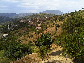
Taliwin Mountain is a mountain peak in the Babor mountain range within the Atlas Hill in Algeria, located in the municipality of Kendira in the Barbacha district in Béjaïa Province.[1]
- ^ Google Maps Archived December 06, 2017 at the Wayback Machine.