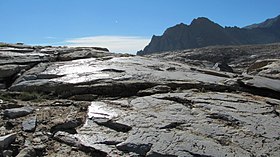
Taboose Pass, 11,417 ft (3,480 m),[1] also known as Wide Gap,[1] is a mountain pass in the southern Sierra Nevada, California on the border of the Inyo National Forest (John Muir Wilderness) to the east and Kings Canyon National Park to the west. The pass is reachable from the east via a long, strenuous hike from the desert floor of the Owens Valley. On the west, it connects to the Pacific Crest Trail/John Muir Trail in the National Park.[2]
Taboose Pass is one of the more difficult Eastern Sierra passes in the Sierra Nevada range, partly due to the low starting elevation of the Owens Valley Trailhead in a desert floor, at 5,500 feet. From the trailhead it is an 8-mile hike, gaining 6,000 feet over that distance to reach the pass at 11,400 feet. Some notable peaks near Taboose Pass include: Split Mountain (the southernmost fourteener in the Palisades group), Cardinal Mountain, Crater Mountain, Goodale Mountain, Mount Ickes, Marion Peak, Mount Pinchot, Mount Ruskin, Striped Mountain, Striped South, Vennacher Needle, White Mountain (at 12,828', not to be confused with the California fourteener with the same name), and Mount Wynne.
^ abc"Taboose Pass". Geographic Names Information System. United States Geological Survey, United States Department of the Interior. 1981-01-19. Retrieved 2017-09-20.
^"Taboose Pass Trail". U.S. Forest Service. Retrieved 2017-09-20.
TaboosePass, 11,417 ft (3,480 m), also known as Wide Gap, is a mountain pass in the southern Sierra Nevada, California on the border of the Inyo National...
The Taboose Fire was a wildfire burning in Inyo National Forest, southwest of Big Pine and northwest of Aberdeen in Inyo County in the state of California...
Section". SummitPost.org. Secor, R. J. (2009). The High Sierra : peaks, passes, trail. Seattle, WA: Mountaineers Books. ISBN 978-0-89886-971-2. Official...
Park. Several passes cross the crest into the park, including Bishop Pass, TaboosePass, Sawmill Pass, and Kearsarge Pass. All of these passes are above 11...
south-southwest of the community of Big Pine, approximately one mile north of TaboosePass, and one mile south-southeast of Split Mountain, which is the nearest...
just over 2 miles to the north of the pass, near the trail turnoff from the John Muir Trail to TaboosePass. The pass is traversed by the John Muir Trail...
northwest of the community of Independence, approximately two miles south of TaboosePass, and 1.9 miles (3.1 km) north of Mount Wynne. Striped Mountain ranks...
northern California. It is situated less than two miles southeast of TaboosePass in the John Muir Wilderness, on land managed by Inyo National Forest...
Trail/John Muir Trail. The trail and river separate at a point west of TaboosePass, where the river turns to the southwest through a deep gorge between...
the Incident Information System". inciweb.nwcg.gov. September 4, 2019. "Taboose Fire Information". inciweb.nwcg.gov. September 9, 2019. "Lime Fire Information"...
of Pika Fire on the Evening of June 28th at 6:30 PM after the storm had passed Wikimedia Commons has media related to Pika Fire. "Yosemite Fire Update...
The Blue Cut Fire was a wildfire in the Cajon Pass, northeastern San Gabriel Mountains, and Mojave Desert in San Bernardino County, California. The fire...
appealed. Some environmentalists charged forest officials with attempting to pass healthy trees as doomed so as to log even more, and by the time the projects...
stabilizing burned areas.: 26 A week later, control over the incident passed from the interagency incident management team back to the Forest Service...
2023 – via Newspapers.com. MacEachern, Michelle (September 10, 2001). "Passes are precious to Yankee Hill residents". Chico Enterprise-Record. pp. 1A...
portion of the fire footprint throughout the winter, and more than a year passed before the fire was declared totally extinguished in November 2014. The...
Archived from the original on September 17, 2020. Retrieved June 26, 2020. "Pass Fire Information". fire.ca.gov. June 28, 2020. Archived from the original...
2020. Garibay, Cassandra (10 September 2020). "Dolan Fire near Big Sur passes 100,000 acres, 14 structures destroyed". The Tribune. Retrieved 14 September...
not outside of its control. Therefore, they ruled, the utility could not pass its uninsured costs along to its ratepayers. The PUC agreed in early December...
28, 2023 – via Newspapers.com. Thayer, Eric (June 9, 2002). "Firefighter pass halfway point in Copper blaze". The Santa Clarita Signal. pp. A1, A8. Retrieved...
was intentionally set near the intersection of Highway 154 (San Marcos Pass Road) and Painted Cave Road, burned 5,000 acres (20 km2), destroyed 427 buildings...
The fire burned 422 acres (171 ha) of land on the slopes of the Sepulveda Pass on its east or Bel Air side, causing the closure of Interstate 405 (as well...
fire crews worked to prevent the fire from spreading north of Beckwourth Pass. The fire briefly jumped north of SR 70 and east of US 395 but was quickly...
acres". fox13now.com. Brian Schnee. June 30, 2020. Retrieved May 3, 2021. "Pass Fire Information". fire.ca.gov. June 28, 2020. Archived from the original...
 Global Information