First Languages: Pashto (90.78%), Kohistani languages (Torwali and Kalami) (7.35%) and others
Lingua Franca: Urdu
Website
swat.kp.gov.pk
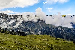
Swat District (Urdu: ضلع سوات, Pashto: سوات ولسوالۍ, pronounced[ˈswaːt̪]), also known as the Swat Valley, is a district in the Malakand Division of Khyber Pakhtunkhwa, Pakistan. Known for its stunning natural beauty, the district is a popular tourist destination. With a population of 2,309,570 per the 2017 national census, Swat is the 15th-largest district of Khyber Pakhtunkhwa.
Swat District is centred on the Valley of Swat, usually referred to simply as Swat, which is a natural geographic region surrounding the Swat River. The valley was a major centre of early Buddhism of the ancient civilisation of Gandhara, mainly Gandharan Buddhism, with pockets of Buddhism persisting in the valley until the 17th century, after which the area became largely Muslim.[4][5][6] Swat was the centre of Hindu Shahis and the Sultanate of Swat. In the early 19th century, Swat emerged as an independent state under Saidu Baba. State of Swat became a Princely state under British suzerainty as part of the British Raj in 1918.
In 1947, following the Partition of British India and subsequent independence of Pakistan, Swat acceded to the Dominion of Pakistan continuing as a self-governing princely state until it was officially annexed and merged into West Pakistan and later became a part of North-West Frontier Province (now Khyber Pakhtunkhwa) in 1969. The region was seized by the Tehrik-i-Taliban in late-2007 until Pakistani control was re-established in mid-2009.[7][8]
The average elevation of Swat is 980 m (3,220 ft),[5] resulting in a considerably cooler and wetter climate compared to the rest of Pakistan. With lush forests, verdant alpine meadows, and snow-capped mountains, Swat is one of the country's most popular tourist destinations.[9][10]
^Malala Yousafzai 2013.
^Cite error: The named reference 2017census was invoked but never defined (see the help page).
^Stephen P. Cohen (2004). The Idea of Pakistan. Brookings Institution Press. p. 202. ISBN 0815797613.
^East and West, Volume 33. Istituto italiano per il Medio ed Estremo Oriente. 1983. p. 27. According to the 13th century Tibetan Buddhist Orgyan pa forms of magic and Tantra Buddhism and Hindu cults still survived in the Swāt area even though Islam had begun to uproot them (G. Tucci, 1971, p. 375) ... The Torwali of upper Swāt would have been converted to Islam during the course of the 17th century (Biddulph, p. 70).
^ abMohiuddin, Yasmeen Niaz (2007). Pakistan: A Global Studies Handbook. ABC-CLIO. ISBN 9781851098019.
^Naik, C. D. (2010). Buddhism and Dalits: Social Philosophy and Traditions. Gyan Publishing House. p. 39. ISBN 978-81-7835-792-8. Buddhism survived in Gilgit and Baltistan until 13-14th Century, perhaps slightly longer in the nearby Swat Valley.
^Abbas, Hassan (24 June 2014). The Taliban Revival: Violence and Extremism on the Pakistan-Afghanistan Frontier. Yale University Press. ISBN 9780300178845.
^Craig, Tim (9 May 2015). "The Taliban once ruled Pakistan's Swat Valley. Now peace has returned". Washington Post. ISSN 0190-8286. Retrieved 11 February 2018.
^Khaliq, Fazal (17 January 2018). "Tourists throng Swat to explore its natural beauty". DAWN.COM. Retrieved 10 February 2018.
^"The revival of tourism in Pakistan". Daily Times. 9 February 2018. Retrieved 12 February 2018.
SwatDistrict (Urdu: ضلع سوات, Pashto: سوات ولسوالۍ, pronounced [ˈswaːt̪]), also known as the Swat Valley, is a district in the Malakand Division of Khyber...
up swat or SWAT in Wiktionary, the free dictionary. Swat or SWAT may refer to: Swat (princely state), a former princely state in the present-day Swat and...
In the United States, a SWAT (special weapons and tactics) team is a generic term for a police tactical unit. SWAT units are generally trained, equipped...
[citation needed] The district was established in 1995, having previously been a subdivision of SwatDistrict. The total area of the district is 1,586 square...
Romanised: Minga Wara) is a city in the SwatDistrict of Khyber Pakhtunkhwa, Pakistan. Located on the Swat River, it is the 3rd largest city in Khyber...
Malakand). The Swat River flows downwards through the district towards the Charsadda District where it falls into the Kabul River. Malakand District is bounded...
Pakistan militants in a fight for control of the Swatdistrict of Pakistan. The first Battle of Swat had ended with a peace agreement, that the government...
Battle of Swat, also known as Operation Rah-e-Haq, was fought between Pakistan and the Tehrik-i-Taliban in late 2007 over control of the SwatDistrict of Pakistan...
province of Pakistan. Before receiving the status of a district in 1991, it was a tehsil within SwatDistrict. Buner's elevation starts at 1200 ft in the South...
Prize by activist Desmond Tutu. On 9 October 2012, while on a bus in SwatDistrict after taking an exam, Yousafzai and two other girls were shot by a Taliban...
Hazara District), Kohistan District (formed out of six tehsils of SwatDistrict and eight union councils of Batagram Tehsil (in Hazara District), and Mansehra...
northern upper section of Swat Valley along the banks of the Swat River in the Khyber Pakhtunkhwa province of Pakistan. The Swat River was formed as a result...
The Swat River (Urdu: دریائے سوات, Pashto: سوات سیند) is a perennial river in the northern region of the Khyber-Pakhtunkhwa Province of Pakistan. The river's...
الودود) was the Wāli of Swat from 1926 until his abdication in 1949. A grandson of the Akhund of Swat, he was elected as ruler of Swat by a loya jirga in November...
Besham was previously a part of the State of Swat and then SwatDistrict, until the creation of Shangla District on 10 July 1995. Tourists pass through Besham...
from the road. Matiltan Utror Gabral Mahodand Ushu Valley Publisher: Tour Swat, Retrieved on 29 September 2012 "Beauty of Usho". attractivepakistan.com...
located in Matta Tehsil in SwatDistrict of Khyber Pakhtunkhwa, the province of Pakistan. It is one of the famous waterfalls of Swat Valley. It is about 30...
again from April 2014 to May 2018. He was born on 17 March 1964 in SwatDistrict, Pakistan. He completed his Intermediate Education (F.Sc.) from Abbottabad...
on the north, Afghanistan on the northwest, the Swatdistrict on the east, and the Lower Dir district on the south. It shares 40 to 50 kilometers border...
Zeb, was the Wāli of Swat from 1949 to 1969, a princely state that is now part of Pakistan. He succeeded his father, Wadud of Swat. He is remembered for...
(newspaper) "2000-year-old Vishnu Temple, water tank, watchtowers discovered in Swat". "PM takes notice of mob attack on temple". "These photos will take you...
 Global Information