Global Information Lookup Global Information

Swarth Fell information


Swarth Fell
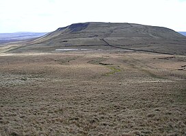
Swarth Fell from Wild Boar Fell
(Photo by John Illingworth)
Highest point
Elevation681 m (2,234 ft)
Prominence76 m (249 ft)
Parent peakWild Boar Fell
ListingHewitt, Nuttall
Coordinates54° 21' 0" N 2° 22' 54" W
Geography
LocationMallerstang, Cumbria, England
Parent rangePennines
OS gridSD7557596660
Topo mapOS Landranger 98

Swarth Fell is an approximately 1 mile (1.5 km) stretch of high ground (consisting mainly of limestone capped with millstone grit) situated to the south of Wild Boar Fell, of which it is a continuation.
It is mostly within Mallerstang, Cumbria, but the boundary between Cumbria and North Yorkshire (historically Westmorland and the West Riding of Yorkshire) runs along its length, just to the west of the highest points.

The summit, (681m, 2234 ft) which is marked by a cairn, and is listed as both a Hewitt and a Nuttall, lies 2.1 km to the south of the summit of Wild Boar Fell, the two fells being separated by a col - where there are several cairns, and a small unnamed tarn. (This small tarn can just be seen in the photograph above right).

Swarth Fell in evening sunlight, seen from Mallerstang, looking south.

The name "Swarth" fell, like most of the names of geographical features in the area, is of Norse origin: svartr, dark in colour.

Approximately 1 km south-east of the summit is the fell's other high point, Swarth Fell Pike (651 m, 2136 ft).
Baugh Fell, Yorkshire Dales, is 5.3 km to the south-west, separated from Swarth Fell by Grisedale.

54°21′54″N 2°22′39″W / 54.36487°N 2.37741°W / 54.36487; -2.37741

and 18 Related for: Swarth Fell information

Request time (Page generated in 0.7648 seconds.)

Swarth Fell

Last Update:

Swarth Fell is an approximately 1 mile (1.5 km) stretch of high ground (consisting mainly of limestone capped with millstone grit) situated to the south...

Word Count : 215

Wild Boar Fell

Last Update:

4th-highest fell in the Yorkshire Dales or the 5th, depending on whether nearby High Seat (2,326 ft) is counted or not. The nearest high point is Swarth Fell which...

Word Count : 617

List of peaks in the Yorkshire Dales

Last Update:

ref. WBF-1 Wild Boar Fell 708 c 344 SD758988 WBF-2 Swarth Fell 681 c 76 SD755966 WBF-3 Little Fell 559 c 30 NY767008 WBF-4 Ash Fell 385 c 77 NY749040 WBF-5...

Word Count : 208

Aisgill

Last Update:

flows south towards Wensleydale, and eventually into the North Sea. Swarth Fell frames the western side of the head of Mallerstang dale, and from Aisgill...

Word Count : 330

Grisedale

Last Update:

miles (3–5 km) long, sandwiched between Baugh Fell to the south-west, Holmes Moss to the west, Swarth Fell Pike to the north, and White Birks Common to...

Word Count : 2456

List of folk songs by Roud number

Last Update:

Praise" 1575. "The Isle of France" 1576. No record 1577. No record 1578. "Swarth Fell Rocks" 1579. "Robbie and Grannie" 1580. "James Waller the Poacher" 1581...

Word Count : 603

List of hills in the Lake District

Last Update:

point between it and the Pennines. This occurs just north of the Howgill Fells and gives the boundaries as, primarily, the River Eden and River Lune. This...

Word Count : 182

Baugh Fell

Last Update:

Baugh Fell is bounded by Garsdale to the south and by the valley of the River Rawthey to the west; on the north-eastern side it adjoins Swarth Fell and...

Word Count : 652

Mallerstang

Last Update:

narrow valley at the head of the River Eden is bounded by Wild Boar Fell and Swarth Fell to the west and Mallerstang Edge to the east. The highest point of...

Word Count : 1627

List of Birketts

Last Update:

English peaks described in Bill Birkett's 1994 guidebook, Complete Lakeland Fells. The author defined them as all hills within the boundary of the Lake District...

Word Count : 1095

Swarthmoor

Last Update:

Village was named after its location on the Swarth Moor, which was formerly a marsh-covered moorland. The Swarth Moor's name was derived from the word sweart...

Word Count : 358

List of Nuttall mountains

Last Update:

100-199m Tump (GB) 0 0-99m Tump (GB) W Wainwright WO Wainwright Outlying Fell B Birkett Sy Synge Fel Fellranger CoH County Top – Historic (pre-1974) CoA...

Word Count : 1909

Gregory Chapel

Last Update:

Grit outcrops on the tops. There are fine views over to Wild Boar Fell and Swarth Fell 5 km to the west, across the dale of Mallerstang. Hill walkers seem...

Word Count : 365

Bonscale Pike

Last Update:

domed intermediate top of Swarth Fell, 1,788 ft (545 m). The ground from here onward is easy going with a covering of fell grass. Bonscale Pike stands...

Word Count : 353

2000 Bihar Legislative Assembly election

Last Update:

and 2000, Bihar's per capita income, according to a World Bank estimate, fell from ₹ 1,373 to ₹ 1,289. Power consumption in Bihar went down from 84 KWH...

Word Count : 974

Alternative versions of Superman

Last Update:

horrific punishments on random citizens to prove his points, and cuts a bloody swarth through his former allies and enemies alike. Near the end of the series...

Word Count : 14398

List of Sites of Special Scientific Interest in North Yorkshire

Last Update:

SE485405 1986 Map [210] Swale Lakes Y 42.5 105.0 SE248985 1986 Map [211] Swarth Moor Y 34.1 85.2 SD806695 1958 Map [212] Swinden Quarry Y Y 112.1 276.9...

Word Count : 351

Stikine River

Last Update:

14 (8): 117–132. Bibcode:1903GSAB...14..117S. doi:10.1130/GSAB-14-117. Swarth, H.S. (1922). "Birds and Mammals of the Stikine River Region of Northern...

Word Count : 9585

PDF Search Engine © AllGlobal.net