This article needs additional citations for verification. Please help improve this article by adding citations to reliable sources. Unsourced material may be challenged and removed. Find sources: "Surajpur district" – news · newspapers · books · scholar · JSTOR(December 2009) (Learn how and when to remove this message)
District of Chhattisgarh in India
Surajpur District
District of Chhattisgarh
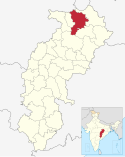
Location in Chhattisgarh
Surajpur district
Country
India
State
Chhattisgarh
Division
District
Headquarters
Surajpur
Tehsils
7
Government
• District Magistrate
Rohit Vyas (IAS)
Area
• Total
2,786.76 km2 (1,075.97 sq mi)
Population
• Total
789,043
• Density
280/km2 (730/sq mi)
Time zone
UTC+05:30 (IST)
PIN
497xxx (Surajpur)[1]
Vehicle registration
CG-29
Major highways
NH 43
Website
surajpur.gov.in
Surajpur district is a district in the state of Chhattisgarh in central India, with its administrative headquarters at Surajpur. National Highway 43 passes through Surajpur district. Surajpur was declared a district on 15 August 2011 along with eight other new districts. Surajpur is the first district to receive National Satyan Maitra Literacy Award. The district is known for its market (economical and quality product) and other major tourist places of Chhattisgarh with Tamor Pingla Wildlife Sanctuary.[2]
^Surajpur
^"Surajpur District". Surajpur.gov.in. 2012. Retrieved 1 March 2017.
through Surajpurdistrict. Surajpur was declared a district on 15 August 2011 along with eight other new districts. Surajpur is the first district to receive...
administration. These districts have been named Sukma, Kondagaon, Balod, Bemetara, Baloda Bazar, Gariaband, Mungeli, Surajpur and Balrampur The district of Gaurela-Pendra-Marwahi...
Surajpur may refer to: Surajpur, Budaun, a village in Ambiapur Block (district subdivision), Budaun district, Uttar Pradesh, India Surajpur, Chhattisgarh...
bifurcation of Dantewada district. Surajpurdistrict was created in 2012 after trifurcation of Surguja district. Fazilka district was formed in 2011, no data...
Surguja & Surajpurdistrict for 160 kilometres (99 mi). The Rihand and its tributaries form a fertile plain in the central part of the district stretching...
centre situated in SurajpurDistrict of the state of Chhattisgarh in India. It is 44 km from the district headquarters of Surajpur. The history of the...
Renuka Singh from the Bharatiya Janata Party. Balrampur district, Chhattisgarh Surajpurdistrict Ambikapur Surguja ka ek Adhyaan, by Samar Bahadur Singhdeo...
Tamor Pingla Wildlife Sanctuary is located in SurajpurDistrict, Chhattisgarh, in central India. It is named after the Tamor Hill and Pingla Nalla, the...
There are 32 districts in the state of Chhattisgarh, which has a total population 25,540,196 as of 2011. Mainly Chhattisgarh(CG) state has large population...
Manendragarh-Chirmiri-Bharatpur district, on the south by Korba District, on the east by SurajpurDistrict. The area of the district is 5977 km2, of which 59...
Indian Railway network. It is the connecting point of Surguja district and Surajpurdistrict and falls within the South East Central Railway zone of the...
Noida West, has nine stations – Phase 2, Phase 3, Bisrakh, Ecotech 3, Surajpur and Badalpur. Zone Three, Greater Noida, has nine police stations — Sector...
Assembly constituencies of Chhattisgarh state in central India. It is in Surajpurdistrict. As of 2023, it is represented by Bhulan Singh Marabi of the Bharatiya...
Personal details Born (1962-02-07) 7 February 1962 (age 62) Chendra, Surajpurdistrict, Madhya Pradesh, India (now in Chhattisgarh, India) Political party...
village in India. It is located in SurajpurDistrict of the state of Chhattisgarh. Surajpurdistrict was declared a district on 15 August 2011 by the State...
and a "Nagar Panchayat" in Surajpurdistrict in the Indian state of Chhattisgarh. Odagi is about 20 km northeast from Surajpur town and is 75 km away from...
2023 – Incumbent Personal details Born 14 September 1954 Pratappur, Surajpurdistrict, Chhattisgarh Political party Indian National Congress Spouse Rama...
the SurajpurDistrict. Ramanuj Nagar is about 21 km northeast from Surajpur and is 60 km away from Ambikapur; the nearest big city. SurajpurDistrict 21°48′N...
registration. These are broken down to states or Union Territories and their districts. The Andhra Pradesh state government has decided to issue uniform registration...
Khelsai Singh (1 January 1947 Shivpur, Surguja district (Madhya Pradesh)) is a leader from Chhattisgarh. He was a member of the Lok Sabha representing...
 Global Information