For the island in the Indian Ocean, see Stewart Island (Andaman Islands). For the atoll in the Solomon Islands, see Stewart Islands. For the island in Greenland, see Steward Island.
Penny Simmonds (New Zealand National Party) Tākuta Ferris (Te Pāti Māori)
Local Government
Regional Council
Environment Southland
Largest settlement
Oban
Territorial authority
Southland District
Community Board
Stewart Island/Rakiura Community Board[2]
Demographics
Population
450 (June 2023)[3]
Pop. density
0.26/km2 (0.67/sq mi)
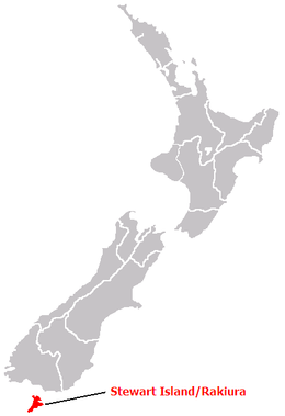
Stewart Island (Māori: Rakiura, lit. 'glowing skies', officially Stewart Island / Rakiura) is New Zealand's third-largest island, located 30 kilometres (16 nautical miles) south of the South Island, across the Foveaux Strait. It is a roughly triangular island with a total land area of 1,746 km2 (674 sq mi). Its 164-kilometre (102 mi) coastline is deeply creased by Paterson Inlet (east), Port Pegasus (south), and Mason Bay (west). The island is generally hilly (rising to 980 metres or 3,220 feet at Mount Anglem) and densely forested. Flightless birds, including penguins, thrive because there are few introduced predators. Almost all the island is owned by the New Zealand government, and over 80 per cent of the island is set aside as the Rakiura National Park.
Stewart Island's economy depends on fishing and summer tourism. Its permanent population was recorded at 408 people in the 2018 census,[4] most of whom live in the settlement of Oban on the eastern side of the island. Ferries connect the settlement to Bluff in the South Island. Stewart Island is part of the Southland District for local government purposes.
^Cite error: The named reference Area was invoked but never defined (see the help page).
^"Stewart Island/Rakiura Community Board". Southland District Council. Retrieved 5 February 2022.
^"Population estimate tables - NZ.Stat". Statistics New Zealand. Retrieved 25 October 2023.
^Cite error: The named reference Census 2018 was invoked but never defined (see the help page).
StewartIsland (Māori: Rakiura, lit. 'glowing skies', officially StewartIsland / Rakiura) is New Zealand's third-largest island, located 30 kilometres...
StewartIsland shag or Stewart shag was the former name of a species of cormorant that was split into two species as a result of genetic studies. The two...
The StewartIsland tokoeka, StewartIsland kiwi, Rakiura tokoeka or Rakiura kiwi (Apteryx australis lawryi) is a subspecies of southern brown kiwi endemic...
through the South Island and StewartIsland/Rakiura, although the distribution is not continuous. The nominate, and the StewartIsland robin (P. australis...
Islands Smith Island Pocock Island Tatle IslandStewart Sound Group Sound Island Swamp IslandStewartIsland Curlew Island Aves Island Karlo Island Interview...
StewartIsland Flights is a commuter airline from New Zealand that conducts scheduled flights on light aircraft between Invercargill and Stewart Island...
Raoul Island North Island South IslandStewartIsland/Rakiura Waiheke Island Niue, a country and single island Northern Mariana Islands Saipan Rota Tinian...
identified the South Island as Middle Island or New Munster, and the name South Island or New Leinster was used for today's StewartIsland / Rakiura. In 1907...
district that covers most of the southern end of the South Island as well as StewartIsland. Southland District was formed through the 1989 local government...
the two main islands. To the south of the South Island, StewartIsland / Rakiura is the largest of the smaller islands, and Waiheke Island in the urban...
ground level. Southern brown kiwi live in the South Island and StewartIsland. On the mainland (South Island) they live in Fiordland and Westland. Their range...
860 km (530 mi) to the southeast of StewartIsland/Rakiura, and 730 km (450 mi) to the northeast of Campbell Island. They are very close to being the antipodal...
clan Clan Stewart of Appin, a Scottish clan Stewart, British Columbia Stewart Township, Nipissing District, Ontario (historical) StewartIsland / Rakiura...
This list of islands by area includes all islands in the world larger than 2,500 km2 (970 sq mi) and most of the islands over 1,000 km2 (390 sq mi), sorted...
Caribbean Islands, with FIPS country code BQ. The populated StewartIslands, called Sikaiana and now effectively controlled by the Solomon Islands, are not...
each of the major islands of New Zealand, the North Island, South Island, and StewartIsland / Rakiura and nearby smaller islands. The species disappeared...
weka. Reintroduced populations are confined to StewartIsland/Rakiura and outliers, and to Kapiti Island to which it was introduced. Weka are host to two...
Martha Helen Stewart (née Kostyra, Polish: [kɔˈstɨra]; born August 3, 1941) is an American retail businesswoman, writer, and television personality. As...
StewartIsland Oban, largest settlement in StewartIsland Paterson Inlet Ulva Island The Snares (not a Scottish name) Broughton Island Ewing Island Port...
Sikaiana (formerly called the StewartIslands) is a small atoll 212 kilometres (132 miles) NE of Malaita in Solomon Islands in the south Pacific Ocean....
North Island, north of the Patea River mouth) New Munster (the North Island south of the Patea River mouth, the South Island and StewartIsland/Rakiura)...
the South Island (or Te Waipounamu) and the North Island (or Te Ika-a-Māui), separated by the Cook Strait. The third-largest is StewartIsland / Rakiura...
Houston StewartIsland is one of the Canadian arctic islands in Nunavut, Canada. Located in the Queens Channel, it is surrounded by larger islands: Devon...
Oliv. - New Zealand (incl. StewartIsland) Coprosma cuneata Hook.f. - New Zealand South Island, StewartIsland, Antipodes Islands Coprosma cymosa [species]...
 Global Information