Global Information Lookup Global Information

Standburn information


Standburn
A road which runs through Standburn
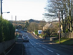
The village of Standburn
Standburn is in the south of the Falkirk council area in the Central Belt of the Scottish mainland.
Standburn
Location within the Falkirk council area
Population149 [1] (2001 census)
OS grid referenceNS925745
Civil parish
  • Muiravonside
Council area
  • Falkirk
Lieutenancy area
  • Stirling and Falkirk
CountryScotland
Sovereign stateUnited Kingdom
Post townFALKIRK
Postcode districtFK1
Dialling code01324
UK Parliament
  • Linlithgow and East Falkirk
Scottish Parliament
  • Falkirk East
Websitefalkirk.gov.uk
List of places
UK
Scotland
55°57′08″N 3°43′17″W / 55.9523°N 3.7215°W / 55.9523; -3.7215

Standburn is a small village which lies within the Falkirk council area in central Scotland. It is located 1.3 miles (2.1 km) south-west of Maddiston, 1.7 miles (2.7 km) north-east of Avonbridge and 4.0 miles (6.4 km) south east of Falkirk. The entire village is located along a section of the B825 road between Avonbridge and Loan.

The United Kingdom Census 2001 reported the population as 149 residents, a figure almost unchanged from the census of 1991

Drumbowie Environment Action Group is a charitable organisation which owns Drumbowie Park to the north of Standburn, this community woodland is open to the public.

Standburn was a mining community with several active pits until the 1950s. The pits were individually numbered and all prefixed by Gateside.[citation needed] The bings from the mining days can still be seen although the land has now been planted with trees and named Gateside Woodland.

  1. ^ No 3 - 2001 Census Population of settlements and wards Archived 2011-06-03 at the Wayback Machine www.falkirk.gov.uk. Retrieved 2011-05-02

and 7 Related for: Standburn information

Request time (Page generated in 0.6107 seconds.)

Standburn

Last Update:

Standburn is a small village which lies within the Falkirk council area in central Scotland. It is located 1.3 miles (2.1 km) south-west of Maddiston...

Word Count : 203

Stirlingshire

Last Update:

Parish South Alloa Stirling see Civil Parish St Ninians see Civil Parish Standburn Strathblane Stenhousemuir Stirling Stoneywood Strathblane see Civil Parish...

Word Count : 2906

FK postcode area

Last Update:

south), Avonbridge, California, Camelon, Limerigg, Shieldhill, Slamannan, Standburn Falkirk FK2 FALKIRK Falkirk (north), Airth, Bainsford, Brightons, Carron...

Word Count : 184

List of places in Falkirk council area

Last Update:

Rumford Shieldhill Skinflats Slamannan South Alloa St Andrew's West Church Standburn Stenhousemuir Stoneywood Tamfourhill Torwood, Torwood Castle Union Canal...

Word Count : 284

Falkirk Braes

Last Update:

Binniehill California 810 Limerigg 219 Shieldhill 2,523 Slamannan 1,382 Standburn 151 Whitecross 776 List of places in Falkirk council area Lower Braes...

Word Count : 877

List of community council areas in Scotland

Last Update:

asterisks have active community councils. Airth Parish* Avonbridge and Standburn* Bainsford, Langlees & New Carron* Banknock, Haggs, Longcroft* Blackness*...

Word Count : 3753

Slamannan Railway

Last Update:

Junction Manuel Causewayend Sheildhall Branch Jn Causewayend Jn Bowhouse Standburn Branch Jn Roughrigg Colliery Blackston Junction Avonbridge Jawcraig Branch...

Word Count : 4152

PDF Search Engine © AllGlobal.net