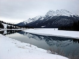
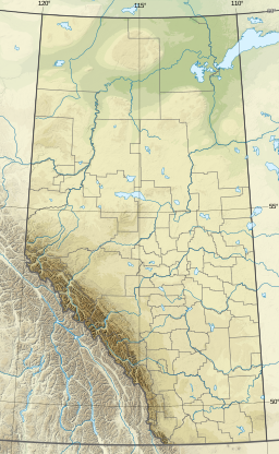
Spray Lakes Reservoir is a reservoir in Alberta, Canada. The Spray Lakes were a string of lakes formed along the Spray River, a tributary of the Bow River. With the damming of the river, the lakes were united in the Spray Lakes Reservoir.
It lies between the Goat Range and the Three Sisters ridge, at an elevation of 1,720 metres (5,640 ft).
The lake is followed by Highway 742 (Smith-Dorrien Trail) in the northern part.
The Lake is impounded by two embankment dams; the 28-metre-high Canyon Dam is near the southern end of the reservoir and blocks the main outlet of the river in a north-northwestern direction, while the secondary 13-metre-high Three Sisters Dam at the northern end of the reservoir provides the outlet for the diverted water way and contains a small 3 MW powerhouse. The two dams and the lake were created in 1951 as part of the Spray Hydro Electric Project. From the Three Sisters Dam the water is diverted into a secondary reservoir known as the Goat Pond which directs the water into a 6-kilometre-long canal which includes an 800-metre tunnel though the shoulder of Ha Ling Peak. From there it enters White Man Pond before being funnelled into a penstock to the main Spray Powerhouse at Grassi Lakes with a generating capacity of 112 MW. The water continues to another shorter penstock leading to the Rundle Powerhouse where an additional 50 MW of generation is available. From there water is released into the Bow River. The four dams and three power stations are owned and operated by TransAlta. The Spray River Project contains a total of five dams and three powerhouses with a total generating capacity of 165 MW, the Spray River diversion making it the highest-yielding conventional (non-pumped-storage) hydroelectric facility in the province.[1]
As a result of the diversion the river's original water course downstream of the Canyon Dam is nothing more than trickle for most of the year.
^"Hydroelectric Facilities". TransAlta.
and 21 Related for: Spray Lakes Reservoir information
SprayLakesReservoir is a reservoir in Alberta, Canada. The SprayLakes were a string of lakes formed along the Spray River, a tributary of the Bow River...
town of Canmore, Alberta. They receive their water from the SprayLakesReservoir on the Spray River. The land is part of the Canmore Nordic Centre Provincial...
enters the SprayLakesReservoir formed in 1951 after the construction of the Canyon Dam. At that point, the river briefly touches the Spray Valley Provincial...
3,107-metre (10,194-foot) triple-peak mountain located between SprayLakesReservoir and the Wind Valley of Kananaskis Country in the Canadian Rockies...
Canadian Rockies in the province of Alberta. It is located in the upper SprayLakes Valley of the Kananaskis Country system of provincial parks. The mountain...
Manicouagan Reservoir (also Lake Manicouagan /mænɪkwɑːɡən, -ɡɒ̃/) is an annular lake in central Quebec, Canada, covering an area of 1,942 km2 (750 sq mi)...
is situated on the east boundary of Banff National Park in the upper SprayLakes River Valley. Named in 1919, Mount Birdwood honors Lieutenant General...
(−22 °F). Precipitation runoff from the mountain drains west into SprayLakesReservoir. Mountains portal Mountains of Alberta Geography of Alberta "Mount...
mountain drains into Smuts Creek and Buller Creek, which empty into SprayLakesReservoir. Geology of the Rocky Mountains Geography of Alberta "Mount Engadine"...
its Ghost Reservoir facility. This was extended in 2016 with a new five-year agreement that included water management of its Kananaskis Lakes system (which...
the mountain drains east into the Kananaskis River and west into SprayLakesReservoir, both of which empty to the Bow River. Mountains of Alberta Geography...
drains to the SprayLakesReservoir. Topographic relief is significant as the summit rises over 1,400 meters (4,600 feet) above SprayLake in three kilometers...
the mountain drains east into the Kananaskis River and west into SprayLakesReservoir which both empty to the Bow River. "Mount Bogart". Bivouac.com....
HMS Chester, which was severely damaged in the Battle of Jutland. Chester Lake is located in a small valley just northwest of the base of the mountain....
drains into Allenby and Mercer creeks which empty to the nearby SprayLakesReservoir via Bryant Creek. Topographic relief is significant as the summit...
from the mountain drains west into Spray River, or east to Smuts Creek, both of which empty into SprayLakesReservoir. Mount Smuts is a difficult and exposed...
HMS Fortune Geography Country Canada Province Alberta Protected area Banff National Park Parent range Park Ranges Topo map NTS 82J14 SprayLakesReservoir...
Commonwealth Peak is a 2,775-metre (9,104-foot) mountain summit in the Spray Mountains, a sub-range of the Canadian Rockies in Alberta, Canada. The mountain...
Alberta Location Alberta Parent range Fisher Range Topo map NTS 82J14 SprayLakesReservoir Climbing Easiest route Easy scramble up the south east face...
Location Alberta, Canada Parent range Spray Mountains Canadian Rockies Topo map NTS 82J14 SprayLakesReservoir Geology Age of rock Cambrian Type of rock...
 Global Information