 Global Information
Spectroradiometry for Earth and planetary remote sensing information
Spectroradiometry is a technique in Earth and planetary remote sensing, which makes use of light behaviour, specifically how light energy is reflected, emitted, and scattered by substances, to explore their properties in the electromagnetic (light) spectrum and identify or differentiate between them.[1] The interaction between light radiation and the surface of a given material determines the manner in which the radiation reflects back to a detector, i.e., a spectroradiometer.[2] Combining the elements of spectroscopy and radiometry, spectroradiometry carries out precise measurements of electromagnetic radiation and associated parameters within different wavelength ranges.[3] This technique forms the basis of multi- and hyperspectral imaging and reflectance spectroscopy, commonly applied across numerous geoscience disciplines, which evaluates the spectral properties exhibited by various materials found on Earth and planetary bodies.[4]
Spectral properties such as brightness and reflectance patterns vary depending on the mineralogical compositions and crystalline structures of the given material.[1] This variation is contributed by the presence of spectrally active components within the material, such as metallic oxides and clay minerals, which give rise to unique absorption features. Upon measurements with a spectroradiometer, these absorption features can be quantified as characteristic absorption bands in a reflectance spectra. The specific shapes associated with the bands that occur at distinctive wavelength positions enable the identification of minerals and facilitate lithological interpretations.[3]
Conventionally, spectroradiometry is applied to the following portions of wavelengths in the electromagnetic (light) spectrum:[2]
- Ultraviolet (UV): 1 nm – 400 nm
- Visible-near Infrared (VNIR): 400 nm – 750 nm
- Short-wave Infrared (SWIR): 750 nm – 2500 nm
- Mid Infrared (MIR): 2500 nm – 5000 nm
- Thermal Infrared (TIR): 7500 nm – 15000 nm
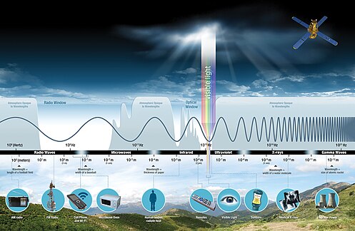
Today, most geological applications with spectroradiometry are focused within the visible-near infrared and short-wave infrared wavelength ranges.[5] Spectroradiometry offers a simple, non-destructive, rapid, and efficient approach that complements traditional and heavy-duty geochemical methods, to characterize mineral assemblages and rock textures. It thereby facilitates the study of geological processes, exploration for natural resources, and reconstruction of past environments and climates.[3][5] Its application extends not only to Earth but also to extraterrestrial planets, broadening our understanding of geological processes beyond our own planet.[6]
| Portal |
|
Earth Sciences Portal |
| Relevant Disciplines |
|
Geology |
|
Remote Sensing |
| Related Information |
|
|
|
- ^ a b van der Meer, F. D.; van der Werff, H. M. A.; van Ruitenbeek, F. J. A.; Hecker, C. A.; Bakker, W. H.; Noomen, M. F.; van der Meijde, M.; Carranza, E. J. M.; de Smeth, J. B.; Woldai, T. (2012). "Multi-and hyperspectral geologic remote sensing: A review". International Journal of Applied Earth Observation and Geoinformation. 14 (1): 112–118. doi:10.1016/j.jag.2011.08.002.
- ^ a b Kardeván, P. (2007). "Reflectance spectroradiometry – a new tool for environmental mapping". Carpathian Journal of Earth and Environmental Sciences. 2 (2): 29–38.
- ^ a b c Ramakrishnan, D.; Bharti, R. (2015). "Hyperspectral remote sensing and geological applications". Current Science: 879–891.
- ^ Ghamisi, P.; Yokoya, N.; Li, J.; Liao, W.; Liu, S.; Plaza, J.; Rasti, B.; Plaza, A. (2017). "Advances in hyperspectral image and signal processing: A comprehensive overview of the state of the art" (PDF). IEEE Geoscience and Remote Sensing Magazine. 5 (4): 37–78. Bibcode:2017IGRSM...5d..37G. doi:10.1109/MGRS.2017.2762087. S2CID 24992843.
- ^ a b Zhao, L.; Hong, H.; Liu, J.; Fang, Q.; Yao, Y.; Tan, W.; Yin, K.; Wang, C.; Chen, M.; Algeo, T. J. (2018). "Assessing the utility of visible-to-shortwave infrared reflectance spectroscopy for analysis of soil weathering intensity and paleoclimate reconstruction". Palaeogeography, Palaeoclimatology, Palaeoecology. 512: 80–94. Bibcode:2018PPP...512...80Z. doi:10.1016/j.palaeo.2017.07.007. S2CID 133726583.
- ^ Liu, J. G.; Mason, P.J. (2016). Image processing and GIS for remote sensing: techniques and applications. John Wiley & Sons.