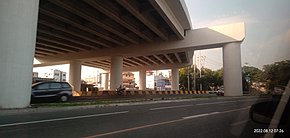
Construction along Carlos P. Garcia Avenue (C-5) in Taguig as of August 2022
Route information
Maintained by SMC Skyway Stage 4 Corporation[1]
Length
32.664 km[2] (20.296 mi)
Component highways
E2[3][4]
Major junctions
South end
AH 26 (E2) (Skyway) at Taguig–Parañaque boundary
North end
Batasan Road in Quezon City
Location
Country
Philippines
Major cities
Antipolo
Marikina
Pasig
Quezon City
Taguig
Towns
Cainta
San Mateo
Taytay
Highway system
Roads in the Philippines
Highways
Expressways
List
The Southeast Metro Manila Expressway (SEMME), also known as Skyway Stage 4, C-6 Expressway and formerly as Metro Manila Expressway, is an under construction[5][6] 32.664-kilometer (20.296 mi)[2] tolled expressway running across eastern Metro Manila and western Rizal. The expressway will help decongest the existing roadways across Metro Manila, such as EDSA and Circumferential Road 5. The expressway is part of the larger C-6 Expressway project.
The expressway will begin at the Skyway near FTI (now Arca South), Taguig, and will end at the Batasang Pambansa Complex in Quezon City. It will also connect to the North Luzon Expressway (NLEx) in Balagtas, Bulacan.[7]
Groundbreaking ceremony of the project was held on January 8, 2018.[7] The project was expected to finish in both 2020 and 2022. However, the project was delayed due to right-of-way issues on the affected properties in Taguig and Rizal.
The construction works of SEMME along Carlos P. Garcia Avenue (C-5 Road) in February 2021.
The entire expressway will be a spur component of Expressway 2 (E2) of the Philippine expressway network.
^"PART I – BUSINESS AND GENERAL INFORMATION" (PDF). San Miguel Corporation. Archived from the original (PDF) on April 30, 2021. Retrieved April 30, 2021.
^ ab"SOUTHEAST METRO MANILA EXPRESSWAY (C6) PROJECT". Department of Public Works and Highways. Retrieved February 24, 2021.
^"Road and Bridge Inventory". Department of Public Works and Highways. Retrieved January 31, 2021.
^"NCR". Department of Public Works and Highways. Retrieved January 31, 2021.
^Camus, Miguel R. (January 8, 2018). "SMC's South East Metro Manila Expressway project begins". Inquirer.net. Retrieved May 5, 2018.
^Dela Paz, Chrisee (January 8, 2018). "San Miguel to start building Southeast Metro Manila Expressway in April". Rappler. Retrieved May 5, 2018.
^ ab"DOTr break ground on South East Metro Manila Expressway project". CNN Philippines. January 8, 2018. Archived from the original on February 14, 2019. Retrieved January 18, 2018.
and 22 Related for: Southeast Metro Manila Expressway information
The SoutheastMetroManilaExpressway (SEMME), also known as Skyway Stage 4, C-6 Expressway and formerly as MetroManilaExpressway, is an under construction...
The MetroManila Skyway, officially the MetroManila Skyway System (MMSS) or simply the Skyway, is an elevated highway serving as the main expressway of...
The Pasig River Expressway (PAREX) was a proposed elevated expressway in MetroManila, Philippines that would have skirted the banks of the Pasig River...
in MetroManila summarizes the major thoroughfares and the numbering system currently being implemented in MetroManila, Philippines. MetroManila's major...
This list of expressways in the Philippines is currently composed of ten controlled-access highways that connects MetroManila to the provinces located...
Other expressways include the Muntinlupa–Cavite Expressway and the NAIA Expressway, with other expressways such as the SoutheastMetroManilaExpressway, C-5...
network of roads and bridges that all together form the fifth beltway of MetroManila in the Philippines. Spanning some 43.87 kilometers (27.26 mi), it connects...
The South Luzon Expressway (SLEX), signed as E2 of the Philippine expressway network and R-3 of the MetroManila arterial road network, is a controlled-access...
Metropolitan Manila (Filipino: Kalakhang Maynila), commonly shortened to MetroManila and formally the National Capital Region (NCR; Filipino: Pambansang...
the possibility of integrating the new stations with the SoutheastMetroManilaExpressway. The privatization of the operations and maintenance of Line...
on 2018-09-01. Retrieved 2018-09-01. "京津城际铁路线路平面示意图". "Lima Metro has the biggest expressway in Latam". Archived from the original on 2014-01-11. "Temburong...
Manila (/məˈnɪlə/ mə-NIL-ə; Filipino: Maynila, pronounced [majˈnilaʔ]), officially the City of Manila (Filipino: Lungsod ng Maynila, [luŋˈsod nɐŋ majˈnilaʔ])...
and Circumferential Road 6 (C-6) runs through the city. The SoutheastMetroManilaExpressway, which is currently under-construction, will traverse parts...
(4.8 mi), four-lane elevated expressway in MetroManila, Philippines. It connects the NLEX Harbor Link to the MetroManila Skyway, which in turn connect...
connector between the North and South Luzon Expressways. The proposed SoutheastMetroManilaExpressway (C-6 Expressway) will connect parts of Quezon City and...
the Greater Manila Area is a major part of the transportation system in MetroManila and its surrounding areas. It consists of the Manila Light Rail Transit...
radium sphere of MetroManila. The DPWH, under JICA's assistance, completed the feasibility study for the proposed Central Luzon Expressway (CLEX) on the...
Ferdinand Marcos. The North Luzon Expressway (NLEX) is a 4 to 8-lane limited-access toll expressway that connects MetroManila to the provinces of the Central...
Kalookan; IPA: [kalɔˈʔokan]), is a 1st class highly urbanized city in MetroManila, Philippines. According to the 2020 census, it has a population of 1...
The Manila Light Rail Transit System, commonly known as the LRT, is an urban rail transit system that primarily serves MetroManila, Philippines. Although...
 Global Information