This article needs additional citations for verification. Please help improve this article by adding citations to reliable sources. Unsourced material may be challenged and removed. Find sources: "South Yorkshire Way" – news · newspapers · books · scholar · JSTOR(March 2022) (Learn how and when to remove this message)
South Yorkshire Way
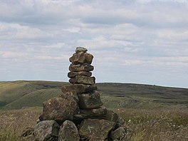
High Stones, Sheffield
Length
Boundary Route 171 miles (275 km) Central Route 98 miles (158 km)
Location
South Yorkshire
Established
2014
Trailheads
Thorne North railway station, South Yorkshire 53°36′58″N0°58′21″W / 53.6162°N 0.9724°W / 53.6162; -0.9724 (South Yorkshire Way Walk, Thorne North railway station) Dore & Totley railway station, South Yorkshire 53°19′39″N1°30′56″W / 53.327570°N 1.515440°W / 53.327570; -1.515440 (South Yorkshire Way Walk, Dore & Totley railway station)
Use
Hiking
Highest point
High Stones
Lowest point
Thorne and Hatfield Moors
Season
All year
Waymark
Yorkshire Rose above 'SY' on green and purple square
The South Yorkshire Way is the name for two interlinked Long Distance footpaths in the county of South Yorkshire. The Boundary Route is a 171-mile (275 km) route around the outskirts of the county, whilst the Central Route is a 98-mile (158 km) route through the heart of the county. Both trails start and end at the same points; Thorne North railway station and Dore & Totley railway station.
They were devised by Andrew White in 2014 to commemorate the 40th anniversary of the formation of South Yorkshire as a county.
and 21 Related for: South Yorkshire Way information
The SouthYorkshireWay is the name for two interlinked Long Distance footpaths in the county of SouthYorkshire. The Boundary Route is a 171-mile (275 km)...
The Yorkshire Wolds Way is a National Trail in Yorkshire, England. It runs 79 miles (127 km) from Hessle to Filey, around the Yorkshire Wolds. At Filey...
The Yorkshire Water Way is a 104-mile (167 km) path that runs from Kettlewell in North Yorkshire to Langsett in SouthYorkshire. It was devised by Mark...
that "changing the way the UK political system works is the best way to address the everyday issues faced by people living in Yorkshire". The party has parish...
administration, Yorkshire retains a strong regional identity. The county was named after its original county town, the city of York. The south-west of Yorkshire is...
The SouthYorkshire Supertram, sometimes referred to as the Sheffield Supertram, is a tram and tram-train network covering Sheffield and Rotherham in...
civil parish in the City of Doncaster, SouthYorkshire, England. Historically within the West Riding of Yorkshire, it had a population of 12,630, increasing...
The SouthYorkshire Mayoral Combined Authority is the combined authority for SouthYorkshire in England, with powers over transport (public transport and...
modern-day SouthYorkshire (Lord John Prescott). Problems playing this file? See media help. Yorkshire dialect (also known as Broad Yorkshire, Tyke, Yorkie...
The SouthYorkshire Coalfield is so named from its position within Yorkshire. It covers most of SouthYorkshire, West Yorkshire and a small part of North...
The Yorkshire Dales are a series of valleys, or dales, in the Pennines, an upland range in England. They are mostly located in the ceremonial county of...
North Yorkshire to the north and east, SouthYorkshire and Derbyshire to the south, Greater Manchester to the south-west, and Lancashire to the west. The...
First SouthYorkshire is a major bus operator providing bus services within and across SouthYorkshire. It is a subsidiary of FirstGroup. In 1989, South Yorkshire...
The South Downs Way is a long distance footpath and bridleway running along the South Downs in southern England. It is one of 16 National Trails in England...
The SouthYorkshire Railway was a railway company with lines in the West Riding of Yorkshire, England. Initially promoted as the SouthYorkshire Coal Railway...
of the walk, as is Walking Home by Yorkshire poet Simon Armitage, who walked north-to-south along the Pennine Way without money, relying on his 'earnings'...
into East Riding of Yorkshire, North Yorkshire (excluding areas in Tees Valley of North East England), SouthYorkshire, West Yorkshire, North Lincolnshire...
The Cleveland Way is a National Trail in the historic area of Cleveland in North Yorkshire, Northern England. It runs 110 miles (177 km) between Helmsley...
Mexborough is a town in the City of Doncaster in SouthYorkshire, England. Situated between Manvers and Denaby Main, it lies on the River Don close to...
Yorkshire is a historic county of England, centred on the county town of York. The region was first occupied after the retreat of the ice age around 8000 BC...
 Global Information