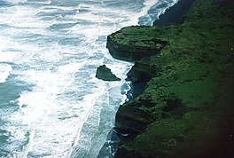
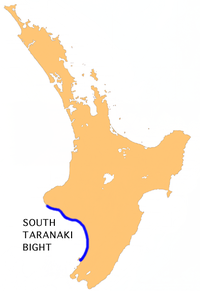
The South Taranaki Bight is a large bay on the west coast of New Zealand, south of Taranaki, west of the Manawatu, north and west of the western entrance of Cook Strait[1] and north of the South Island.[2] The name is sometimes used for a much smaller bay in South Taranaki, between the mouth of the Kaupokonui Stream directly south of Mount Taranaki and the mouth of the Pātea River.[3]
Approximately 18,000 years ago during the Last Glacial Maximum when sea levels were over 100 metres lower than present day levels, the South Taranaki Bight was a coastal plain which connected the North and South Islands, featuring rivers which drained into the Cook Strait (then a harbour) to the south-east. Sea levels began to rise 7,000 years ago, eventually separating the islands and connecting the Cook Strait to the Tasman Sea.[4]
The bight was once a calving ground for southern right whales in winter and spring and early Europeans in New Zealand called it Mothering Bay after the large number of cow-calf pairs. However right whale numbers were greatly reduced by whaling and only a handful of cows visit regularly today.[5][6] Pygmy blue whales were discovered off Cape Egmont in 2007 and the South Taranaki Bight was confirmed in 2014 as the only known feeding and foraging ground for blue whales in New Zealand, hosting a unique population of its own.[7][8] Blue whales also frequent an area off Kahurangi Point in the nearby northern South Island.[2]
A seabed survey by the National Institute of Water and Atmospheric Research in 2023 found that the bight contained 14 rocky reefs with abundant life including "kelp forests, macroalgal meadows, and gardens of 39 species of sponge. Blue cod (including nurseries at four sites), scarlet wrasse, butterfly perch, leatherjackets and tarakihi dominated the fish species, also including snapper, trevally, kingfish, and kahawai".[9]
Australian-owned mining company Trans-Tasman Resources has proposed to mine iron sand from the bight.[9]
^Grant-Taylor, Thomas Ludovic (1966). "South Taranaki Bight". In McLintock, A.H. (ed.). An Encyclopaedia of New Zealand. Retrieved 31 October 2020 – via Te Ara – the Encyclopedia of New Zealand.
^ abTorres, Leigh G. (2013). "Evidence for an unrecognised blue whale foraging ground in New Zealand". New Zealand Journal of Marine and Freshwater Research 47(2). ResearchGate. Retrieved 3 March 2017.
^South Taranaki Bight Factual Baseline Environmental Report(PDF). Wellington: National Institute of Water and Atmospheric Research. 2011. p. 54.
^"Estuary origins". National Institute of Water and Atmospheric Research. Retrieved 3 November 2021.
^Poynton, Dan (28 July 2005). "Rare whales sighted at Castlecliff". Whanganui Chronicle. Retrieved 31 October 2020 – via The New Zealand Herald.
^Taranaki – Where We Stand: State of the Environment Report 2009(PDF). Taranaki Regional Council. 2009. p. 177. ISBN 978-0-473-14731-0. Retrieved 31 October 2020.
^Torres, Leigh; Klinck, Holger et al. (2016). Blue whale ecology in the South Taranaki Bight region of New Zealand: January-February 2016 Field Report Archived 2017-03-03 at the Wayback Machine (pdf). Retrieved 3 March 2017.
^Harper, Laird (4 February 2014). "Blue whale dine out off Taranaki in their dozens". Taranaki Daily News. Retrieved 31 October 2020 – via Stuff.
^ abCraig Ashworth (17 April 2024). "Pātea seabed mining fight continues". NZ Herald. Retrieved 17 April 2024.
and 21 Related for: South Taranaki Bight information
The SouthTaranakiBight is a large bay on the west coast of New Zealand, south of Taranaki, west of the Manawatu, north and west of the western entrance...
name is echoed by the SouthTaranakiBight to the south of Cape Egmont. As with its southern counterpart, the size of the bight depends to a large extent...
Taranaki. The region covers an area of 7258 km2. Its large bays north-west and south-west of Cape Egmont are North TaranakiBight and SouthTaranaki Bight...
one of areas being frequented by pygmy blue whales along with off SouthTaranakiBight which was discovered in 2007 and was confirmed in 2014. "Place name...
Pātea River flows through the town from the north-east and into the SouthTaranakiBight. Patea is the traditional final place where some Māori led by Turi...
tsunami that occurred between 1470 and 1510 was associated with the SouthTaranakiBight possibly extended down to Abel Tasman National Park. Evidence of...
Hauraki Gulf Firth of Thames Hawke Bay Ninety Mile Beach North TaranakiBightSouthTaranakiBight Lake Taupō Waikato River Whanganui River Coromandel Peninsula...
by the vast coastal plains which formed at the SouthTaranakiBight which connected the North and South islands. Sea levels began to rise 7,000 years ago...
Manawatū-Whanganui region of New Zealand's North Island. It is located on the SouthTaranakiBight at the mouth of the Manawatu River, 35 kilometres southwest of Palmerston...
the Tasman Sea and the Lau Basin in winter and feed mostly in the SouthTaranakiBight and off the coast of eastern North Island. Blue whales have been...
Ohawe is at the mouth of the Waingongoro River, where it reaches the SouthTaranakiBight. The name means "place of a river bend", referring to the winding...
levels, the North and South Islands were connected by a vast coastal plain which formed at the SouthTaranakiBight. Similarly, the South Island and Stewart...
on the SouthTaranakiBight in SouthTaranaki, New Zealand. Waverley is 18.5 km to the north-west by road, and Whanganui is 42 km to the south-east. Road...
Whangarei Harbour, Foveaux Strait, SouthTaranakiBight, Moutohora Island and Wineglass Bay. Hermanus in South Africa has become known as a centre for...
country to the east of Lake Rotorangi, reaching the Tasman Sea in the SouthTaranakiBight 5 km (3.1 mi) southeast of Hawera. An elder, of Tangahoe and Ngāti...
Manawatū-Whanganui region of New Zealand's North Island. It is located on the SouthTaranakiBight, 14 kilometres northwest of Levin, and 17 kilometres southwest of...
Egmont Cape Egmont, splitting Northern and Southern TaranakiBights, is the westernmost point of Taranaki, on the west coast of New Zealand's North Island...
present day levels, the North and South islands were connected by a vast coastal plain which formed at the SouthTaranakiBight. During this period, most of...
ford. The river flows for 161 kilometres (100 mi) southward to the SouthTaranakiBight near the settlement of Whangaehu. The sudden collapse of part of...
in northern Taranaki, in the North Island of New Zealand. It is located on State Highway 3 close to the shore of the North TaranakiBight, 13 kilometres...
crater lake of Mount Ruapehu on the central plateau, southward to the SouthTaranakiBight in the Tasman Sea. Water is diverted from the headwaters for the...
 Global Information