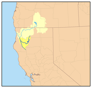
The South Fork Trinity River is the main tributary of the Trinity River, in the northern part of the U.S. state of California.[1]
It is part of the Klamath River drainage basin. It flows generally northwest from its source in the Klamath Mountains, 92 miles (148 km) through Humboldt and Trinity Counties, to join the Trinity near Salyer. The main tributaries are Hayfork Creek and the East Fork South Fork Trinity River.[2] The river has no major dams or diversions, and is designated Wild and Scenic for its entire length.
One of the largest undammed river systems in California, the South Fork drains a rugged, remote watershed of 980 square miles (2,500 km2). The large areas of intact habitat are important for several endangered species and rare plants. Historically, the South Fork watershed was known for its prodigious anadromous fish population and dense old-growth forests. During the mid-20th century, the river channel was heavily damaged by major flooding, which was exacerbated by erosion caused by mining, logging and ranching. Decades later the South Fork is still considered in the process of recovery.[3]
^"South Fork Trinity River". Geographic Names Information System. United States Geological Survey, United States Department of the Interior. 19 January 1981. Retrieved 2009-07-29.
^"Where and What is the South Fork Trinity River Watershed?" (PDF). South Fork Trinity River Coordinated Resources Management Planning Group. Trinity County Resource Conservation District. Retrieved 2009-07-29.
^"California Rivers: South Fork Trinity River". Friends of the River. www.friendsoftheriver.org. Retrieved 2009-07-29.
and 18 Related for: South Fork Trinity River information
The SouthForkTrinityRiver is the main tributary of the TrinityRiver, in the northern part of the U.S. state of California. It is part of the Klamath...
lower SouthForkTrinityRiver (yisinch'ing-qeh), Willow Creek (xoxol-ding), Salyer (miy-me'), Burnt Ranch (tse:n-ding/tse:ning-ding) and New River (Yiduq-nilin)...
The North ForkTrinityRiver is a tributary of the TrinityRiver in the U.S. state of California. It flows south through the Klamath Mountains for about...
valley on the lower course of the TrinityRiver between the confluence of SouthForkTrinityRiver and the Klamath River. The valley opens up above the confluence...
tributary of the SouthForkTrinityRiver in Northern California in the United States. At over 50 miles (80 km) long, it is the river's longest tributary...
Creek Range Creek West ForkTrinityRiver Johnson Creek Clear ForkTrinityRiver Big Sandy Creek Cedar Bayou San Jacinto River Buffalo Bayou Vince Bayou...
district of Hyampom, a town in Trinity County, California, United States, and bordering the SouthForkTrinityRiver on its west side. Hyampom has condominiums...
River and Redwood Creek; toward the east the Wintu of SouthForkTrinityRiver; toward the south the Wailaki, from whom they were separated by Kekawaka...
The SouthFork Eel River is the largest tributary of the Eel River in north-central California in the United States. The river flows 105 miles (169 km)...
of the SouthForkTrinityRiver and Cottonwood Creek. A spur of the mountain, Skylight Ridge, touches the headwaters of the Middle Fork Eel River, making...
Soon after this, SR 299 crosses into Trinity County and Trinity National Forest. Paralleling the TrinityRiver, SR 299 passes through Salyer (where there...
Musselshell River is a tributary of the Missouri River, 341.9 miles (550.2 km) long from its origins at the confluence of its North and SouthForks near Martinsdale...
Highway" for additional documentation See also HAER No. CA-271, "Los Angeles River Bridges" for additional documentation See also HAER No. PA-645, "Structural...
streams of the North ForkTrinityRiver and New River watersheds have spawning chinook salmon, and some have steelhead. The Trinity Alps are home to much...
 Global Information