 Global Information
South Downs information
| South Downs | |
|---|---|
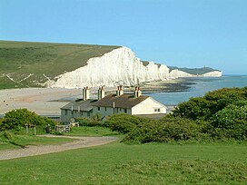 The Seven Sisters, near Eastbourne, viewed from Seaford Head | |
| Highest point | |
| Peak | Butser Hill |
| Elevation | 271 m (889 ft) |
| Coordinates | 50°58′40″N 0°58′49″W / 50.97778°N 0.98028°W |
| Dimensions | |
| Area | 670 km2 (260 sq mi) |
| Naming | |
| Etymology | Old English dūn, meaning 'hill' |
| Geography | |
| Country | England (United Kingdom) |
| Region | Hampshire, East Sussex, West Sussex |
| Range coordinates | 50°54′N 0°30′W / 50.9°N 0.5°W |
| Parent range | Southern England Chalk Formation |
| Geology | |
| Orogeny | Alpine orogeny |
| Age of rock | Cretaceous |
| Type of rock | Chalk |
The South Downs are a range of chalk hills in the south-eastern coastal counties of England that extends for about 260 sq mi (670 km2)[1] across the south-eastern coastal counties of England from the Itchen valley of Hampshire in the west to Beachy Head, in the Eastbourne Downland Estate, East Sussex, in the east. The Downs are bounded on the northern side by a steep escarpment, from whose crest there are extensive views northwards across the Weald. The South Downs National Park forms a much larger area than the chalk range of the South Downs, and includes large parts of the Weald.
The South Downs are characterised by rolling chalk downland with close-cropped turf and dry valleys, and are recognised as one of the most important chalk landscapes in England.[2] The range is one of the four main areas of chalk downland in southern England.[3]
The South Downs are relatively less populated compared to South East England as a whole, although there has been large-scale urban encroachment onto the chalk downland by major seaside resorts, including most notably Brighton and Hove. The South Downs have been inhabited since ancient times and at periods the area has supported a large population, particularly during Romano-British times. There is a rich heritage of historical features and archaeological remains, including defensive sites, burial mounds and field boundaries. Within the South Downs Environmentally Sensitive Area there are thirty-seven Sites of Special Scientific Interest, including large areas of chalk grassland.[4]
The grazing of sheep on the thin, well-drained chalk soils of the Downs over many centuries, and browsing by rabbits, resulted in the fine, short, springy turf, known as old chalk grassland, that has come to epitomise the South Downs today. Until the middle of the 20th century, an agricultural system operated by downland farmers known as 'sheep-and-corn farming' underpinned this: the sheep (most famously the Southdown breed) of villagers would be systematically confined to certain corn fields to improve their fertility with their droppings and then they would be let out onto the downland to graze. However, starting in 1940 with government measures during the Second World War to increase domestic food production – which continued into the 1950s - much grassland was ploughed up for arable farming, fundamentally changing the landscape and ecology, with the loss of much biodiversity. As a result, while old chalk grassland accounted for 40-50% of the eastern Downs before the war, only 3-4% survives.[5] This and development pressures from the surrounding population centres ultimately led to the decision to create the South Downs National Park, which came into full operation on 1 April 2011, to protect and restore the Downs.
The South Downs have also been designated as a National Character Area (NCA 125) by Natural England. It is bordered by the Hampshire Downs, the Wealden Greensand, the Low Weald and the Pevensey Levels to the north and the South Hampshire Lowlands and South Coast Plain to the south.[6]
The downland is a highly popular recreational destination, particularly for walkers, horseriders and mountain bikers. A long distance footpath and bridleway, the South Downs Way, follows the entire length of the chalk ridge from Winchester to Eastbourne, complemented by many interconnecting public footpaths and bridleways.

- ^ The land area figure cited here relates to the South Downs Environmentally Sensitive Area, as defined by Natural England for its Environmentally Sensitive Area scheme (launched 1987, but now closed to new applicants, having been replaced by the Environmental Stewardship scheme). The South Downs ESA is referred to by Peter Brandon when he defines the extent of the South Downs; see Brandon (1998), p.1.
- ^ Source: Natural England, South Downs ESA.
- ^ The others being the North Downs of Kent and Surrey; the Chilterns to the north-west of London; and the North Wessex Downs of Wiltshire, Dorset, Hampshire and Berkshire.
- ^ Source: Natural England.
- ^ Peter Brandon, The South Downs (Halsgrove, Tiverton, 2003), p. 51.
- ^ South East and London National Character Area map Archived 24 April 2013 at the Wayback Machine at www.naturalengland.org.uk. Accessed on 3 April 2013.