 Global Information
Souris River information
| Souris River Mouse River, Rivière Souris | |
|---|---|
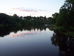 The river in the town of Souris, Manitoba | |
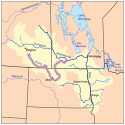 The Red River drainage basin, with the Souris River highlighted | |
| Location | |
| Countries |
|
| Provinces |
|
| State | North Dakota |
| Cities |
|
| Physical characteristics | |
| Source | north of Weyburn |
| • location | Saskatchewan |
| • coordinates | 49°49′53″N 103°47′46″W / 49.83139°N 103.79611°W |
| Mouth | Assiniboine River |
• location | Manitoba, Canada |
• coordinates | 49°39′54″N 99°34′07″W / 49.66500°N 99.56861°W |
| Length | 435 mi (700 km) |
| Basin size | 23,600 sq mi (61,000 km2) |
| Discharge | |
| • location | Weyburn, SK; river mile 97.9 (river kilometre 157.6) |
| Basin features | |
| River system | Red River drainage basin |
| Tributaries | |
| • left | Antler |
| • right | Gainsborough |
| [1][2] | |

The Souris River (/ˈsʊərɪs/; French: rivière Souris) or Mouse River (as it is alternatively known in the U.S., a translation of its French name) is a river in central North America. Approximately 435 miles (700 km) in length, it drains about 23,600 square miles (61,100 km2) in Canada and the United States.
Rising in southern Saskatchewan in the Yellow Grass Marshes north of Weyburn, the river wanders southeast into the U.S. through North Dakota beyond Minot to its most southern point at Velva, and then back north into Canada in southwestern Manitoba.
Flowing east, it passes through the communities of Melita, Hartney, Souris, and Wawanesa prior to the confluence with the Assiniboine River near Treesbank, about 25 miles (40 km) southeast of Brandon. The main tributaries of the Souris in Manitoba are the Antler River, Gainsborough Creek, and Plum Creek. The elevation at the confluence is approximately 1,120 feet (340 m) above sea level.
At the end of the last ice age, over 10,000 years ago, the rapid draining of former Glacial Lake Regina eroded a large channel that is now occupied by the much smaller contemporary Souris River.[3] Also, much of the drainage basin is fertile silt and clay deposited by another former glacial lake, Lake Souris.
- ^ "Natural Resources Canada-Canadian Geographical Names (Souris River)". Retrieved 2014-08-29.
- ^ "Atlas of Canada Toporama". Retrieved 2014-08-29.
- ^ "Proglacial Lakes". Esask. Government of Saskatchewan. Retrieved 31 March 2022.