287 km (178 mi)[1] 333 km (207 mi) including intervening roadway.[1]
Gazetted
August 1928 (as Main Road 4)[2]
Route number(s)
B72 (2013–present)
Former route number
National Route 18 (1955–2013)
Major junctions
Eastern section
East end
Princes Highway Stony Creek, New South Wales
Mogilla Road
West end
Monaro Highway Steeple Flat, New South Wales
Western section
East end
Monaro Highway Cooma, New South Wales
Kosciuszko Road
Wee Jasper Road
Gocup Road
West end
Hume Highway Mount Adrah, New South Wales
Location(s)
Major settlements
Adelong, Tumut Adaminaby, Cooma
Restrictions
General
Within Kosciuszko National Park, it is recommended that two-wheel drive vehicles carry snow chains during winter.[3]
Highway system
Highways in Australia
National Highway • Freeways in Australia
Highways in New South Wales
----
Infobox instructions
guidelines
examples
talk
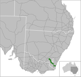
Snowy Mountains Highway is a 333-kilometre-long (207 mi)[1] state highway located in New South Wales, Australia. Its two sections connect the New South Wales South Coast to the Monaro region, and the Monaro to the South West Slopes via the Snowy Mountains. The higher altitude regions of this road are subject to snow over the winter months, and the road also provides access to many parts of the Snowy Mountains Scheme. The highway bears the B72 shield along its entire length.
The highway originally bore the name Monaro Highway until 1958, when it received its current name. It originally ran from Tathra to Wagga Wagga but has been shortened to run from Princes Highway to Hume Highway instead. Part of the roadway was reallocated to what is now known as Monaro Highway in 1955. Reservoirs created as a result of dams built in the 1950s and 1960s as part of the Snowy Mountains Scheme required the creation of major realignments to avoid submerged areas. Previous to New South Wales' conversion to alphanumeric route markers, it was signed as National Route 18.
^ abcGoogle (13 August 2022). "Snowy Mountains Highway" (Map). Google Maps. Google. Retrieved 13 August 2022.
^"Main Roads Act, 1924-1927". Government Gazette of the State of New South Wales. No. 110. National Library of Australia. 17 August 1928. pp. 3814–20. Archived from the original on 3 August 2022. Retrieved 1 August 2022.
^"Driving in the snow". NSW Government – Office of Environment and Heritage. 19 July 2011. Retrieved 27 July 2013.
and 22 Related for: Snowy Mountains Highway information
SnowyMountainsHighway is a 333-kilometre-long (207 mi) state highway located in New South Wales, Australia. Its two sections connect the New South Wales...
The SnowyMountains Scheme, also known as the Snowy Hydro or the Snowy scheme, is a hydroelectricity and irrigation complex in south-east Australia. Near...
of the national capital, Canberra, via the Monaro Highway. It is also on the SnowyMountainsHighway, connecting Bega with the Riverina. At the 2016 census...
B72 between the two sections of SnowyMountainsHighway. Monaro Highway begins at the intersection with Princes Highway in Cann River in the East Gippsland...
spillway with two vertical lift gates across the Eucumbene River in the SnowyMountains of New South Wales, Australia. The dam's main purpose is for the generation...
/ædəˈmɪnəbi/ is a small town near the SnowyMountains north-west of Cooma, New South Wales, Australia, in the Snowy Monaro Regional Council. The historic...
Adelong Road (the SnowyMountainsHighway) and a chipboard panel factory next door. 8 km further west on the SnowyMountainsHighway at Gilmore the company...
same name. It is located on the Tumut River upstream of Tumut in the SnowyMountains region of New South Wales, Australia. Purposes for the dam include...
September 2014. Retrieved 22 September 2014. SnowyMountainsHighway Main Roads September 1955 page 4 "The Sturt Highway". Main Roads. V (I). NSW Department of...
the unlit caves, helmets and lights are provided. Sparks, Hannah. "SnowyMountains drawcard reopens after bushfire". About Regional. Retrieved 7 December...
Wyoming Highway 130 (WYO 130) is a 98.52-mile-long (158.55 km) state highway in the U.S. State of Wyoming. It is known locally as the Snowy Range Road...
western side of the highway close to the interchange with the SnowyMountainsHighway. North of Albury, a major deviation of the highway was constructed in...
Australia's highways such as the Alpine Way, Great Alpine Road, SnowyMountainsHighway, Hume Highway, Illawarra Highway, Northern Highway, Melba Highway, Maroondah...
The Australian Alps consist of two biogeographic sub regions: the SnowyMountains, including the Brindabella Range, located in New South Wales and the...
Pass in Kosciuszko National Park. Kosciuszko Road branches from SnowyMountainsHighway in Pine Valley, nearly 7km west of Cooma, and heads roughly westwards...
the eastern slopes of the SnowyMountains in New South Wales, before flowing through the Alpine National Park and the Snowy River National Park in Victoria...
Alpine Way is a 121-kilometre (75 mi) rural road located in the SnowyMountains region of New South Wales, Australia. The road connects Jindabyne in the...
The Eucumbene River, a perennial river of the Snowy River catchment, is located in the SnowyMountains region of New South Wales, Australia. The Eucumbene...
(State Highway 6) from Hay to the state border with South Australia. eventually to Adelaide via Renmark; the western end of Monaro Highway (today Snowy Mountains...
The Snowy Scheme Museum is a museum in the SnowyMountains town of Adaminaby, New South Wales, Australia. It houses exhibitions relating to the Snowy Mountains...
 Global Information