 Global Information
Sirkkalankatu information
| Sirkkalagatan (Swedish) | |
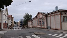 View towards east at the intersection of Sirkkalankatu and Kotikatu | |
| Former name(s) | Arseninkatu, Arsenin poikkikatu |
|---|---|
| Length | 1.5 km (0.93 mi) |
| Location | Turku, Finland |
Sirkkalankatu (Swedish: Sirkkalagatan; lit. Sirkkala Street) is a street in Turku. It runs for approximately 1.5 km in the city's I, II and III District beginning at Joukahaisenkatu and ending at Kivenhakkaajankatu near the Turku Sports Park.[1]
Sirkkalankatu got its current name during the 1920s. Before that the street was known as Arseninkatu.[2]
The street is located in a hilly area, and public transport bus routes only run between Kerttulinkatu and Joukahaisenkatu. Buildings along the street include the former Sirkkala barracks, Luostarinmäki Handicrafts Museum, the Turunmaa Hospital and the former maternity hospital Heideken.[1]
- ^ a b "Sirkkalankatu". Turun karttapalvelu (in Finnish). Turun kaupunki. Retrieved 18 November 2021.
- ^ Kupila, Sanna; Söderström, Marita, eds. (2011). Turun katuja ja toreja: Nimistöhistoriaa keskiajalta nykypäivään (in Finnish). Turku: Turun museokeskus. pp. 299, 386–387. ISBN 9789515951502.