USGS Crescent Valley, Simpson Park and Summit Mountain 30x60 quads
The Simpson Park Mountains, also known as the Simpson Park Range, are located in Lander and Eureka counties, in central Nevada in the western United States. The mountains reach an elevation of 9,147 feet (2,788 m) at Fagin Mountain, and cover an area of approximately 310 square miles (800 km2). US Route 50 crosses the very southern end of the range at Hickison Summit between Eureka and Austin.
The range runs in a southwest-northeasterly direction between the Toiyabe Range on the west across Grass Valley and the Roberts Mountains to the east. Other ranges around the Simpson Parks include the Cortez Mountains to the north across Horse Creek Valley and the Toquima and Monitor ranges to the south. The Monitor, Kobeh and Antelope valleys lie to the southeast.[3][4][5]
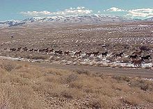
Horses crossing a plain near the Simpson Park Wilderness Study Area
The Hickison Petroglyph Recreation Area lies at the southeastern end of the mountains northwest of Hickison Summit on US route 50. The Bureau of Land Management manages 98% of the Simpson Park Mountains, and 2% is privately held. Principal vegetation types are: Piñon-juniper—43.5%, Sagebrush scrub—25.4%, and Sagebrush steppe—18.5%. Trees found in the range include: western juniper (Juniperus occidentalis), Utah Juniper (Juniperus osteosperma), and Single-leaf Pinyon (Pinus monophylla). Coyotes and pikas roam the Simpson Park Mountains.
The range is named after James H. Simpson, who surveyed a transportation route just south of the range in 1858.[6]
^"Simpson Park Mountains". Geographic Names Information System. United States Geological Survey, United States Department of the Interior. Retrieved 2009-05-04.
^U.S. Geological Survey Geographic Names Information System: Simpson Park Mountains
^Simpson Park Mts., Nevada, 30x60 Minute Quadrangle, USGS 1979
^Crescent Valley, Nevada, 30x60 Minute Quadrangle, USGS 1987
The SimpsonParkMountains, also known as the SimpsonPark Range, are located in Lander and Eureka counties, in central Nevada in the western United States...
a town Simpson Conservation Park, a protected area in South Australia Simpson Desert, a big one Simpson, Saskatchewan Simpson Pass, a mountain pass on...
SimpsonPark is a valley south of Grass Valley, Nevada that contained a Pony Express station location of Pony Express Division Four. "SimpsonPark Station...
artist. Simpson's style has been met with critical favor and frequent comparisons to outlaw country. His first two albums, High Top Mountain and Metamodern...
Roberts Mountains are located in central Nevada in the western United States. The mountains are found in Eureka County, east of the SimpsonParkMountains and...
Nicole Brown Simpson (née Brown; May 19, 1959 – June 12, 1994) was the second wife of American football player O. J. Simpson. Brown met Simpson in 1977 and...
northwest, the Pinon and Sulphur Springs ranges to the east, the SimpsonParkMountains to the south and the Toiyabe Range to the southwest across the narrow...
located in the Denay Valley, which lies between the SimpsonParkMountains and the Roberts Mountains. Earth sciences portal United States portal Paleontology...
Yellowknife, protects a portion of the Mackenzie Mountains Natural Region. The centrepiece of the park is the South Nahanni River (Naha Dehé). Four noteworthy...
article List of mountain ranges of Arizona List of mountain ranges of California List of mountain ranges of Oregon List of mountain ranges of the Lower...
The Simpsons is an American animated sitcom created by Matt Groening for the Fox Broadcasting Company. Developed by Groening, James L. Brooks, and Sam...
Black Mountains, which extend beyond the national park boundary into England, and to the west is the similarly named but distinct Black Mountain range...
Berkeley. Gregory and his field team found these fossils near the SimpsonParkMountains in Eureka County, Nevada. They came from a deposit called the Red...
The mountain's name was officially adopted in 1973 by the Geographical Names Board of Canada. Like other mountains in Banff Park, Mount Jimmy Simpson is...
the mountain plum-pine, a low-lying type of conifer. The Alpine Way and Snowy Mountains Highway are the major roads through the Snowy Mountains region...
through the Rocky Mountains, a national park so that road could be funded as a park improvement. With the popularity of Rocky MountainsPark, the Commissioner...
commercially. The Arbuckle Mountains are the oldest known formations in the United States between the Appalachian and Rocky Mountains. They contain a core of...
Glass House Mountains National Park is a heritage-listed national park at Glass House Mountains, Sunshine Coast Region, Queensland, Australia. It is also...
popular hiking and running destination. The mountains trails are also commonly utilized by mountain bikers. The park is open 9:30am to 9:00pm during most of...
used by early trappers, or mountain men, as a term for a large mountain valley. These low-lying valleys, surrounded by mountains and containing rivers and...
Mountain-Southeast Peak". Peakbagger.com. Green Trails Maps Map of Cougar and Squak Mountains. Washington State Parks Map of Squak Mountain State Park....
Deltaform Mountain is one of the mountains in the Valley of the Ten Peaks, located on the Continental Divide on the border of British Columbia and Alberta...
ISSN 1027-5606. Mountains portal Geography of British Columbia Parks Canada web site: Yoho National ParkParkMountain and Odaray Mountain panoramic photo:...
Landscape of the Cairngorm Mountains. p. 22 "What to look for in mountains and moorlands". Cairgorms Nature (Cairngorms National Park Authority ). Retrieved...
 Global Information