 Global Information
Shropshire information
Shropshire | |
|---|---|
Ceremonial county | |
The Long Mynd; the clock tower of Shrewsbury Market Hall; and the Iron Bridge, Ironbridge | |
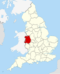 Shropshire within England | |
| Coordinates: 52°37′N 2°43′W / 52.617°N 2.717°W | |
| Sovereign state | United Kingdom |
| Constituent country | England |
| Region | West Midlands |
| Established | Ancient |
| Time zone | UTC+0 (GMT) |
| • Summer (DST) | UTC+1 (BST) |
| Members of Parliament | List of MPs |
| Police | West Mercia Police |
| Ceremonial county | |
| Lord Lieutenant | Anna Turner JP[1] (from 2019) |
| High Sheriff | Robert Anthony Morris-Eyton (2021/22) |
| Area | 3,487 km2 (1,346 sq mi) |
| • Ranked | 13th of 48 |
| Population (2022) | 498,073 |
| • Ranked | 42nd of 48 |
| Density | 143/km2 (370/sq mi) |
| Ethnicity | Figures for Shropshire UA:[2] 93.8% White, British 1.9% White, other 1.5% S. Asian 0.9% Mixed 0.6% White, Irish 0.6% Black |
| Unitary authorities | |
| Councils | Shropshire Council Telford and Wrekin Council |
| Districts | |
 Districts of Shropshire Unitary | |
| Districts |
|


Shropshire (/ˈʃrɒpʃər, -ʃɪər/; historically Salop[3] and abbreviated Shrops) is a ceremonial county in the West Midlands of England, on the Welsh border. It is bordered by Wrexham County Borough and Cheshire to the north, Staffordshire to the east, Worcestershire to the south-east, Herefordshire to the south and Powys to the west. The largest settlement is Telford, and Shrewsbury is the county town.
The county has an area of 3,487 km2 (1,346 square miles) and a population of 498,073. Telford (155,570), in the east of the county, and Shrewsbury (76,782), in the centre, are the only large towns. Shropshire is otherwise rural, containing market towns such as Oswestry (15,613), Bridgnorth (12,212) and Newport (11,387). For local government purposes the county comprises two unitary authority areas: Shropshire, and Telford and Wrekin.
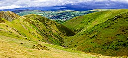
Shropshire is generally flat in the north and hilly in the south. The Shropshire Hills AONB covers about a quarter of the county, including the Wrekin, Clee Hills, Stiperstones, the Long Mynd, and Wenlock Edge.[4][5] Part of the Fenn's, Whixall and Bettisfield Mosses National Nature Reserve, which extends into Wales, occupies the low-lying north west of the county.[6] The county's major river is the Severn, which enters from the west and forms a wide, flat valley before exiting into Worcestershire south of Bridgnorth. The village of Edgmond, near Newport, is the location of the lowest recorded temperature in England and Wales.[7]
There is evidence of Neolithic and Bronze Age human occupation in Shropshire, including the Shropshire bulla pendant. The hillfort at Old Oswestry dates from the Iron Age, and the remains of the city of Viroconium Cornoviorum date from the Roman period.[8][9] During the Anglo-Saxon era the area was part of Mercia. During the High Middle Ages the county was part of the Welsh Marches, the border region between Wales and England; from 1472 to 1689 Ludlow was the seat of the Council of Wales and the Marches, which administered justice in Wales and Herefordshire, Shropshire, Worcestershire and Gloucestershire.[10] During the English Civil War Shropshire was Royalist, and Charles II fled through the county—famously hiding in an oak tree—after his final defeat at the Battle of Worcester.[11] The area around Coalbrookdale is regarded as one of the birthplaces of the Industrial Revolution and has been designated a UNESCO World Heritage Site.[12][13]
- ^ "Shropshire Lieutenancy | Shropshire Council". Government of the United Kingdom. Retrieved 20 April 2020.
- ^ Rogers, Simon (19 May 2011). "Ethnic breakdown of England and Wales mapped". The Guardian.
- ^ Also used officially as the name of the county from 1974–1980. The demonym for inhabitants of the county "Salopian" derives from this name.
- "Salopian definition and meaning". Collins Dictionary. Retrieved 20 June 2023.
- "Salop definition and meaning". Collins Dictionary. Retrieved 8 April 2018.
- ^ Shropshire Hills AONB. Shropshire Hills AONB. Retrieved 25 August 2011.
- ^ shropshirerocks.org: Wenlock Edge Archived 19 November 2008 at the Wayback Machine
- ^ "Fenn's, Whixall & Bettisfield Mosses National Nature Reserve (leaflet)". Natural England. Retrieved 4 September 2023.
- ^ "Climate in Wales". Archived from the original on 14 August 2007.
- ^ "History of Old Oswestry Hillfort". English Heritage. Retrieved 4 September 2023.
- ^ "History of Wroxeter Roman City". English Heritage. Retrieved 4 September 2023.
- ^ "The Council of Wales and the Marches". BBC. 7 November 2012. Retrieved 4 September 2023.
- ^ "Boscobel House: Charles II and the Royal Oak". English Heritage. Retrieved 4 September 2023.
- ^ Trinder, A History of Shropshire (1980) p.77.
- ^ Ironbridge Page on UNESCO World Heritage website. UNESCO (6 March 2007). Retrieved 25 August 2011.