Local Government Area (LGA) in Victoria, Australia
Moira Shire Council Victoria
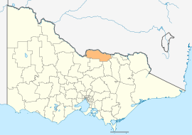
Location in Victoria
Population
30,522 (2021 census)[1]
• Density
7.5456/km2 (19.5430/sq mi)
Established
1994
Gazetted
18 November 1994[2]
Area
4,045 km2 (1,561.8 sq mi)[1]
Council seat
Cobram
Region
Hume
State electorate(s)
Ovens Valley
Shepparton
Federal division(s)
Nicholls
Website
Moira Shire Council
LGAs around Moira Shire Council:
Murray River (NSW)
Berrigan (NSW)
Federation (NSW)
Murray River (NSW)
Moira Shire Council
Indigo
Campaspe
Greater Shepparton
Benalla Wangaratta
Moira Shire Council is a Local Government Area in the Northern Victoria Region of Victoria, Australia. Located in the north-east part of the state, it covers an area of 4,045 square kilometres (1,562 sq mi). As at August 2021 the population was 30,522.[1]
It includes the towns of Cobram, Nathalia, Numurkah, Tungamah and Yarrawonga. It was formed in 1994 from the amalgamation of the Shire of Cobram, Shire of Nathalia, Shire of Numurkah, and parts of the Shire of Tungamah and Shire of Yarrawonga.[2]
The Shire is governed and administered by the Moira Shire Council; its seat of local government and administrative centre is located at the council headquarters in Cobram, it also has a service centre located in Yarrawonga. The Shire is named after the county of Moira, of which the LGA occupies the northern part.
^ abcAustralian Bureau of Statistics (28 June 2022). "Moira (Local Government Area)". 2021 Census QuickStats. Retrieved 19 November 2023.
^ abVictoria Government Gazette – Online Archive (1837–1997). "S87 of 1994: Order estg (Part 11) the Shire of Moira". State Library of Victoria. State Government of Victoria (published 18 November 1994). p. 4. Retrieved 10 January 2014.
MoiraShire Council is a Local Government Area in the Northern Victoria Region of Victoria, Australia. Located in the north-east part of the state, it...
the nearby towns of Numurkah and Yarrawonga is part ofShireofMoira and is the administrative centre of the council. Its twin town of Barooga is located...
The Division of Nicholls is an Australian Electoral Division in the state of Victoria, which was contested for the first time at the 2019 federal election...
a shire and is governed by a shire council. Local councils have the same administrative functions and similar political structures, regardless of their...
Highway, 37 kilometres (23 mi) north of Shepparton, in the ShireofMoira. At the 2016 census, Numurkah had a population of 4,768. The area was occupied by...
a highway located in Victoria, Australia. The section north of the Hume Freeway is part of the Melbourne to Brisbane National Highway (together with Hume...
located in the ShireofMoira local government area on the Murray Valley Highway and Goulburn Valley Highway, about 11 kilometres (7 mi) west of Cobram. At...
district of Shepparton is a rural Lower House electoral district of the Victorian Parliament. It is located within the Northern Victoria Region of the Legislative...
electorates. Section 24 of the Constitution of Australia specifies that the total number of members of the Australian House of Representatives shall be...
Picola is a town in the ShireofMoira in northern Victoria, Australia. At the 2021 census, Picola had a population of 206. The name Picola is thought...
and other towns in the local government areas of Moira, Wangaratta, and Alpine. The abolished seat of Murray Valley was held by Nationals MP Tim McCurdy...
in northern Victoria, Australia in the ShireofMoira local government area, 228 kilometres (142 mi) north of the state capital, Melbourne. The area is...
Australia about 46 kilometres north east of Shepparton. At the 2011 census, Katamatite had a population of 433. Katamatite is located in the Murray Valley...
This is a list of places on the Victorian Heritage Register in the ShireofMoira in Victoria, Australia. The Victorian Heritage Register is maintained...
Australia. The town is located in the ShireofMoira local government area, 264 kilometres (164 mi) north of the state capital, Melbourne on the Goulburn...
is a town in the state of Victoria, Australia. Barmah has the distinction of being located north of the border with the state of New South Wales. New South...
Rural City of Wangaratta and the ShireofMoira local government area between Wangaratta and Yarrawonga and 277 kilometres (172 mi) north east of the state...
Boweya North is a town located in the ShireofMoira local government area. According to the 2016 Australian census, the population in the locality was...
The locality is the ShireofMoira local government area. At the 2011 census, Yabba North and the surrounding area had a population of 256. It has a disused...
Constituting the Shires of Towong, Indigo, Milawa, Delatite, Strathbogie, Murrindindi, Mitchell, Moira and (etc.) – Part 6: Alpine Shire". Victoria Government...
 Global Information