This article is about the district. For its eponymous headquarters, see Serchhip.
District of Mizoram in India
Serchhip district
District of Mizoram
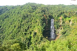
Vantawng Falls
Location in Mizoram
Serchhip district
Country
India
State
Mizoram
Headquarters
Serchhip
Government
• Lok Sabha constituencies
Mizoram
• Vidhan Sabha constituencies
3
Area
• Total
1,422 km2 (549 sq mi)
Population
(2011)
• Total
64,937
• Density
46/km2 (120/sq mi)
Demographics
• Literacy
97.91%
• Sex ratio
977 per thousand
Time zone
UTC+05:30 (IST)
Website
serchhip.nic.in
Serchhip District is one of the eleven districts of Mizoram state in India. The district occupies an area of 1421.60 km2. Serchhip town is the administrative headquarters of the district. This district came into existence on 15 September 1998, being carved out of the larger Aizawl District.[1] Because of the way it was created it includes part of East Lungdar Tehsil and part of Thingsulthliah Tehsil.[1][2]
As of 2011 census, it has the highest literacy rate in India, and is the second least populous district of Mizoram (out of 8), after Saiha.[3]
^ ab"District Census Handbook, Serchhip: Village and town Wise Primary Census Abstract (PCA)" (PDF). Census 2011, Mizoram. Directorate of Census Operations, Mizoram. Archived (PDF) from the original on 25 August 2015.
^Bhatt, S. C.; Bhargava, Gopal K., eds. (2006). "Chapter 7. Government and Politics". Land and People of Indian States and Union Territories, volume 19 Mizoram. Delhi, India: Kalpaz Publications. pp. 65–70, page 69. ISBN 81-7835-375-X.
^"District Census 2011". Census2011.co.in. 2011. Retrieved 30 September 2011.
SerchhipDistrict is one of the eleven districts of Mizoram state in India. The district occupies an area of 1421.60 km2. Serchhip town is the administrative...
headquarters of the Serchhip district. Serchhip is located at 23°18′N 92°50′E / 23.3°N 92.83°E / 23.3; 92.83. Serchhip is connected by Pawan Hans Helicopter...
Khuangtuaha in 1942 as a millennialist denomination, which survives in Serchhipdistrict in Mizoram state of India, sharing borders with Bangladesh and Myanmar...
Highest waterfall in India is Kunchikal waterfall located in Shimoga district of Karnataka. "Tallest and Largest Waterfalls at the World Waterfall Database"...
constituency since the first elections in the state in 1972. It is part of Serchhipdistrict and is reserved for candidates belonging to the Scheduled tribes....
Manipur state, on the west by Saitual and Serchhipdistricts, and on the south and east by Myanmar. The district occupies an area of 3,185.83 km2 (1,230...
Vantawng Khawhthla is located 5 kilometres (3.1 mi) south of Thenzawl in Serchhipdistrict in the Indian state of Mizoram. It is the highest uninterrupted waterfall...
organisation involved in charitable activities in and around Serchhip Town and Serchhipdistrict in the state of Mizoram in India. It was founded in 2010...
voter participation was at Serchhipdistrict at (84.78%), followed by the Mamit district (84.23%) and the Hnahthial district (84.1%). The Assembly constituency...
Tuirihiau Falls is located 5 kilometres (3.1 mi) south of Thenzawl in Serchhipdistrict in the Indian state of Mizoram. Tuirihiau Falls Khawhthla or Tuirihiau...
census2011.co.in. "Saiha District Religion Data - Hindu/Muslim". www.census2011.co.in. "SerchhipDistrict Religion Data - Hindu/Muslim". www.census2011.co.in....
A district (zila), also known as revenue district is an administrative division of an Indian state or territory. In some cases, districts are further...
Started by a World War I veteran Khuangtuaha in 1942, it flourishes in Serchhipdistrict. Originally from Hmawngkawn village, the followers resettled at the...
Ministers & Governors of Mizoram". Office of the Deputy Commissioner, SerchhipDistrict. Archived from the original on 12 December 2023. Retrieved 12 December...
Vantawng Falls is located 5 kilometres (3.1 mi) south of Thenzawl in Serchhipdistrict in the Indian state of Mizoram. It is a two-tiered waterfall with...
Congress Committee from 1973 to 2021. His electoral constituencies were Serchhip and Hrangturzo from where he successfully contested the Mizoram Legislative...
were districts winner and seven from a audition in Aizawl. The winner was Zirsangpuii of Khawzawl, Vengthar (Miss Mizoram 2020 Khawzawl District ). 1...
Ramthlengliana, IPS Lunglei Eastern Range Champhai District, Khawzawl District, Saitual District and SerchhipDistrict Thomas Zodingliana, IPS Aizawl...
The Thenzawl golf course is a public golf course in a meadow at Thenzawl in Mizoram, India. The golf course is set at an altitude of 2568 feet. It is owned...
Thenzawl is a census town in Serchhipdistrict in the Indian state of Mizoram. It is a center for the traditional Mizo handloom industry. Thenzawl is...
New Serchhip is the northern extension of Serchhip Town in Mizoram State of India. It was created and inhabited since 1976. Town bus, taxi and auto-rickshaw...
Reserve Districts of Mizoram Aizawl district Champhai district Kolasib district Lawngtlai district Lunglei district Mamit district Saiha districtSerchhip district...
Lunglei and Chhimtuipui. Later five more districts were carved out of the already existing three districts. A district of Mizoram is headed by a Deputy Commissioner...
Personal details Born (1954-02-04) 4 February 1954 (age 70) Hualtu SerchhipDistrict, Mizoram Political party Indian National Congress Spouse Ramthanpari...
In the 2001 census it was listed in SerchhipDistrict; however in the 2011 census it was listed in Champhai District. As of 2001[update] India census, North...
Hindu and Buddhist-influenced sculptures at Kolalian village in the Mamit district. The area belong to Reangs( Bru) Tribes who worship Hindu deities. The...
 Global Information