M4 motorway bridge over the Severn Estuary in the United Kingdom
Prince of Wales Bridge Pont Tywysog Cymru(Welsh) (Second Severn Crossing)
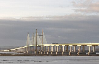
The bridge as viewed from Severn Beach (England)
Coordinates
51°34′28″N2°42′06″W / 51.5745°N 2.7016°W / 51.5745; -2.7016 (Prince of Wales Bridge (approximate midpoint))
Carries
M4 motorway (6 lanes)
Crosses
River Severn
Locale
South West England / South East Wales
Official name
Prince of Wales Bridge (since 2 July 2018)
Other name(s)
Welsh: Ail Groesfan Hafren or Pont Tywysog Cymru
Named for
River Severn or Charles, Prince of Wales
Maintained by
National Highways[1][2]
Characteristics
Design
Central span: Cable-stayed bridge Approach viaducts: Segmental bridge
Total length
5,128 metres (16,824 ft)
Width
34.6 metres (113.5 ft)
Height
137 metres (449 ft)
Longest span
456 metres (1,496 ft)
Clearance below
37 metres (121 ft)
History
Architect
Ronald Weeks of the Percy Thomas Partnership
Engineering design by
Halcrow Group and SEEE [fr]
Opened
5 June 1996; 28 years ago (5 June 1996)
Statistics
Daily traffic
61,455 (2008)[3]
Toll
Free
Location
Map showing the Second Severn Crossing in relation to other crossings and the estuary itself
The Second Severn Crossing (Welsh: Ail Groesfan Hafren), officially named the Prince of Wales Bridge (Welsh: Pont Tywysog Cymru) since July 2018, is the M4 motorway bridge over the River Severn between England and Wales, opened in 1996 to supplement the traffic capacity of the Severn Bridge built in 1966. The bridge is operated by England's National Highways. It has a total length of 5,128 metres (16,824 ft).
It is southwest of the Severn Bridge and because it is more closely in line with the rest of the M4, it reduces the length of the journey between England and Wales. The junctions at each end are designed for most traffic to use this crossing, and in order to use the old Severn Bridge, one has to leave the M4 at junction 21 and join the M48 near Aust or at junction 23 near Magor. The new crossing carries more traffic than the Severn Bridge, which is still in use. It is wider than the Severn Bridge, having three lanes and a narrow hard shoulder each way, compared to the two lanes, cycle path and narrow footpath of the original crossing. It is a cable-stayed bridge, whereas the Severn Bridge is a suspension bridge. The position of the bridge is close to that of the Severn Tunnel, which has carried the railway line beneath the river bed since 1886.
Much of the estuary is mudflats at low tide, but at high tide these can be covered by as much as 14 metres (46 ft) of water. This presented the engineers with a constraint: packets of work were scheduled at low tide, and needed to be completed within the short windows allowed by the tides.
The concession given to the consortium which financed, built and operate the bridge required them to take over the outstanding debt on the original Severn Bridge and to operate the two bridges as a single entity. Tolls were set annually by the government based on the previous year's change in the Retail Price Index. On the expiry of the concession in January 2018, the consortium was required to hand the bridge over to public ownership. The tolls on both bridges were subsequently scrapped in December 2018.
^"Highways England network management" (PDF). gov.uk. Highways England. Retrieved 22 April 2019.
^"Severn Bridges will be owned by the government from tomorrow as tolls to be scrapped in 2018". Bristol Post. Trinity Mirror. 7 January 2018. Retrieved 22 April 2019.
^"The Impact of the Severn Tolls on the Welsh Economy" (PDF). Welsh Government. Retrieved 5 March 2021.
and 25 Related for: Second Severn Crossing information
The SecondSevernCrossing (Welsh: Ail Groesfan Hafren), officially named the Prince of Wales Bridge (Welsh: Pont Tywysog Cymru) since July 2018, is the...
Severncrossing is a term used to refer to the two motorway crossings over the River Severn estuary between England and Wales operated by England's National...
village. The Severn footpath – on the sea wall – is part of the Severn Way that leads from Gloucester, Slimbridge and the SecondSevernCrossing. Extensive...
England and Monmouthshire in South East Wales. It is the original Severn road crossing between England and Wales, and took three and a half years to build...
is usually considered to end, and the Severn Estuary to begin, after the SecondSevernCrossing, between Severn Beach in South Gloucestershire and Sudbrook...
Motorway crossings over the River Severn This is a list of crossings of the River Severn in Great Britain (including bridges, tunnels, ferries and fords)...
Briton Ferry bridge remained until 1993. On the opening of the SecondSevernCrossing in 1996, the M4 was rerouted over it. The line of the motorway from...
the ferry was compared to the Aust crossing the most direct route into South Wales. In 1996 the SecondSevernCrossing road bridge was completed, virtually...
over the SecondSevernCrossing, it was anticipated that these services may close. The original building offered views of the River Severn. It was sold...
substantial railway tunnel and motorway bridge. The Severn Tunnel opened in 1885 and the SecondSevernCrossing opened in 1996. The village is home to St Peters...
projects planned or under construction in the UK, including the SecondSevernCrossing. From 1981 until the establishment of the private finance initiative...
Another milestone was attained in 1990 in the construction of the SecondSevernCrossing, which was the first PPP to be conducted by John Laing. During June...
viaduct in Great Britain, being 1⁄4 mile (400 metres) longer than the SecondSevernCrossing. It was constructed during the period 1964–1972. Between 2012 and...
part of the Caldicot Levels on the Welsh shore of the Severn Estuary. The SecondSevernCrossing passes overhead carrying the M4 motorway. The community...
county has a shoreline on the Severn Estuary, with crossings into England by the Severn Bridge and SecondSevernCrossing. The name derives from the historic...
the SecondSevernCrossing near Severn Beach, South Gloucestershire. The definition used on Admiralty Chart SC1179 and the Bristol Channel and Severn Cruising...
England Combined Authority. Gloucestershire is bisected by the river River Severn, which enters the county near Tewkesbury and forms a wide valley down its...
The Severn Tunnel (Welsh: Twnnel Hafren) is a railway tunnel in the United Kingdom, linking South Gloucestershire in the west of England to Monmouthshire...
Bristol West of Bristol, the E30 crosses the River Severn over the SecondSevernCrossing. The Severn Bridge is used as an alternative to and from Chepstow...
in the UK and one of the biggest in Europe. The opening of the SecondSevernCrossing in 1996 resulted in the previous M4 and bridge, serving Chepstow...
its terminal junction with the M4 at junction 22, just before the SecondSevernCrossing at Pilning Interchange. It cuts journey times for traffic to and...
canalised West Channel of the River Severn near Gloucester, England. It links Over to Alney Island. Although there was a crossing at Over recorded in the Domesday...
reach of the main motorways in the area, including the M5, the M4 SecondSevernCrossing, and the M49, and it is served by the A4 Portway and by Shirehampton...
throughout the year. The barrage would be located just below the SecondSevernCrossing—i.e. above Cardiff and Bristol on the estuary—and so much smaller...
 Global Information