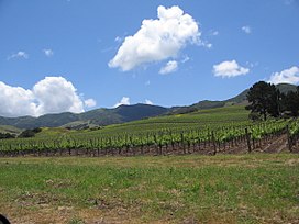
The Santa Ynez Valley (Spanish: Valle de Santa Ynez)[1][2] is located in Santa Barbara County, California, between the Santa Ynez Mountains to the south and the San Rafael Mountains to the north. The Santa Ynez River flows through the valley from east to west. The Santa Ynez Valley is separated from the Los Alamos Valley, to the northwest, by the Purisima Hills, and from the Santa Maria Valley by the Solomon Hills.[3][4] The Santa Rita Hills separate the Santa Ynez Valley from the Santa Rita and Lompoc Valleys to the west.[5][6][7]
The valley has a population of about 20,000 residents living in the communities of Solvang, Los Olivos, Santa Ynez, Buellton, and Ballard.
^Santa Maria Times - Clima cálido invade la Costa Central, el Valle de Santa Ynez podría superar los 3 dígitos
^Santa Barbara Land Trust - Rancho Felicia, Valle de Santa Ynez
^U.S. Geological Survey Geographic Names Information System: Purisima Hills
^U.S. Geological Survey Geographic Names Information System: Solomon Hills
^U.S. Geological Survey Geographic Names Information System: Santa Rita Hills
^U.S. Geological Survey Geographic Names Information System: Santa Rita Valley
^U.S. Geological Survey Geographic Names Information System: Lompoc Valley
is 92 miles (148 km) long, flowing from east to west through the SantaYnezValley, reaching the Pacific Ocean at Surf, near Vandenberg Space Force Base...
(2 km) southeast of the central business district of SantaYnez, in the SantaYnezValley of Santa Barbara County, California, United States. The airport...
The SantaYnezValley AVA is an American Viticultural Area located in Santa Barbara County, California and was established on May 16, 1983 by the Alcohol...
vast majority of the vineyards residing in seven AVAs: Santa Maria Valley, SantaYnezValley, Sta. Rita Hills, Happy Canyon, Ballard Canyon, Los Olivos...
miles (13 km) north of the town of SantaYnez. Originally named Zaca Laderas Ranch, the estate was renamed Sycamore Valley Ranch shortly after it was purchased...
Valley News. March 27, 1980. p. 1. Retrieved December 17, 2022 – via Newspapers.com. "Christiansen gets life imprisonment (1/2)". SantaYnezValley News...
SantaYnezValley Union High School (SYHS) is a public high school in SantaYnez, California that serves students in grades 9–12 in the SantaYnez Valley...
SantaYnezValley Cottage Hospital is a hospital in the city of Solvang, California. It is owned and operated by Cottage Health. The hospital was featured...
SantaYnez Fault is a left-reverse fault in Santa Barbara County of California. Its length is at least 130 km., running through SantaYnez and north of...
Ynez Valley, formed by the SantaYnez River, between the Purisima Hills above Solvang. The area encompasses the townships of Los Olivos, Ballard, Santa Ynez...
has one older sister and two younger brothers, and grew up in the SantaYnezValley, a noted wine-producing region north of Los Angeles. Growing up he...
Los Padres National Forest, and connects Los Olivos (and the SantaYnezValley) with Santa Barbara, California along the Pacific coast. The road has been...
The film drew attention and increased tourism to the SantaYnezValley wine-growing region in Santa Barbara County and California's Central Coast. During...
owned and operated by the SantaYnez Band of Chumash Mission Indians. Chumash is located near SantaYnez Airport, in the SantaYnez Indian Reservation, about...
Cachuma Lake is a reservoir in the SantaYnezValley of central Santa Barbara County, California on the SantaYnez River adjoining the north side of California...
viticultural area. As of 2021, the SantaYnezValley AVA contains three other established viticultural areas: Santa Rita Hills, which lies to the west;...
 Global Information