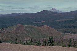
View down the north–northeast alignment of the Sand Mountain Volcanic Field, with Mount Jefferson visible in the distance
Location
Oregon, United States
Range
Cascade Range
Age
Holocene
Elevation
5,459 feet (1,664 m)[1]
Volcanic arc/belt
Cascade Volcanic Arc
Last eruption
70 AD/2,000 years ago[1]
The Sand Mountain Volcanic Field (also known as the Sand Mountain Field) is a volcanic field in the upper McKenzie River watershed, located in the United States in Oregon. Part of the Cascade Volcanic Arc, it lies southwest of Mount Jefferson and northwest of Belknap Crater and Mount Washington. Its highest elevation is 5,463 feet (1,665 m).
Active during the Holocene epoch, the Sand Mountain Field began erupting about 4,000 years ago. The field includes 23 basaltic and basaltic andesitic cinder cones and lava flows, for a total of 42 volcanic vents within two roughly north–south trending alignments. Its total dense-rock equivalent eruptive output is 0.22 to 0.29 cubic miles (0.92 to 1.21 km3), with subfeatures including a tephra field and a lava tube system. Future activity is possible, but according to the Volcano Hazards Program of the United States Geological Survey, the threat from the field itself is low.
The field lies within the Willamette National Forest near Santiam Pass. It supports some forested areas, which grow well on lava flows with tephra that serves as suitable soil for stands of Douglas fir and western hemlock and less commonly western red cedar. The surroundings represent an area of geological interest, and scoria has been quarried from one of the field's volcanic cones for highway supplies. Nearby tourist destinations include a ski resort, Tamolitch Falls, and Clear Lake.
^ ab"Sand Mountain Volcanic Field". Volcano Hazards Program. United States Geological Survey. February 2, 2015. Archived from the original on December 21, 2018. Retrieved December 21, 2018.
and 27 Related for: Sand Mountain Volcanic Field information
Georgia) SandMountain (Florida), a hill in Florida SandMountain (Nevada), a singing sand dune in Nevada SandMountainVolcanicField, a volcanicfield in...
Olallie Butte, a shield volcano Blue Lake Crater, a maar SandMountainVolcanicField, a volcanicfield Mount Washington (Oregon), a shield volcano or stratovolcano...
Three Fingered Jack. Along with lava flows from the SandMountainVolcanicfield and other young volcanic centers in the Santiam and McKenzie Pass area, many...
wind-driven sand or ice crystals Volcanic arc – Chain of volcanoes formed above a subducting plate Volcanic cone – Landform of ejecta from a volcanic vent piled...
which are dotted with 1⁄2 to 1 foot (0.15 to 0.30 m) of ash from the SandMountain cinder cone chain and 1 foot (0.30 m) of ash from the Blue Lake Crater...
Craters Lava Field is a basaltic volcanicfield located south east of Newberry Caldera in the U.S. state of Oregon. The volcanicfield covers about 30...
The Marrah Mountains or Marra Mountains (Fur, Fugo Marra; Arabic: جبل مرة, Jebel Marra) are a range of volcanic peaks in a massif that rises up to 3,042...
Lunar Crater volcanicfield is a volcanicfield in Nye County, Nevada. It lies along the Reveille and Pancake Ranges and consists of over 200 vents, mostly...
amounts of sediment from the volcanic San Juan Mountains continued to wash down into these lakes, along with some sand from the Sangre de Cristo Range...
Devils Garden VolcanicField is a volcanicfield located south east of Newberry Caldera in Oregon. The lava field consists of several flows of pahoehoe...
plates, such as in the East African Rift and the Wells Gray-Clearwater volcanicfield and Rio Grande rift in North America. Volcanism away from plate boundaries...
summit on its north side. Lava Butte is part of the Newberry National Volcanic Monument. Like the other cinder cones in the area, Lava Butte only experienced...
Portland, Oregon, United States. It is also part of the Boring Lava Field, a group of volcanic vents and lava flows throughout Oregon and Washington state. The...
The Navajo volcanicfield is a monogenetic volcanicfield located in the Four Corners region of the United States, in the central part of the Colorado...
Oregon, United States. It is part of the Boring Lava Field, which includes more than 80 small volcanic edifices and lava flows in the Portland–Vancouver...
History and Culture. "Arbuckle Mountains." Retrieved October 7, 2013. ""America's Volcanic Past: Oklahoma:Arbuckle Mountains."". Archived from the original...
In a volcanic eruption, lava, volcanic bombs, ash, and various gases are expelled from a volcanic vent and fissure. While many eruptions only pose dangers...
massif within the park. The area is an active volcanic complex surrounded by a plain of sand. The volcanic complex of Tengger forms a condition where a...
Jefferson in northwestern Oregon SandMountainVolcanicField in west central Oregon near Mount Jefferson Wapi Lava Field in southeastern Idaho near Pocatello...
California. The most recent volcanic activity was about 11,000 years ago. The Pinacate Desert is home to the largest sand dunes of the Americas. A variety...
Hager Mountain is a volcanic peak in Oregon in the northwest corner of the Basin and Range Province in the United States. The mountain is located south...
can see Broken Top, Mt. Bachelor, and the Three Sisters Complex. Tumalo Volcanic Center "Tumalo Mt". NGS Data Sheet. National Geodetic Survey, National...
Colorado Plateau may postdate the Laramide orogeny. Minette of the Navajo VolcanicField intruded and was extruded through the Chuska Sandstone. Minette makes...
Zuni-Bandera volcanicfield, Mount Taylor volcanicfield, the Jemez volcanicfield, the Taos Plateau volcanicfield, and the Raton-Clayton volcanicfield. The...
time than surrounding volcanic centers, Olallie has been excavated by glacial erosion on its northeastern flank. Its central volcanic plug has also been...
the predominant volcanic rock in the McLoughlin Reach, though Pelican Butte is andesitic in composition along with nearby Brown Mountain and the dissected...
 Global Information