"Pak Nam" redirects here. For other uses, see Pak Nam (disambiguation).
Province in Thailand
Samut Prakan province
จังหวัดสมุทรปราการ
Province
Other transcription(s)
• Teochew
北欖Pāk-năm(Peng'im)
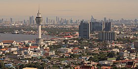
From top: Wat Phra Samut Chedi, Phi Sua Samut Fort, Samut Prakarn Tower.
Flag
Seal
Nickname(s):
Muang Pak Nam (Thai: เมืองปากน้ำ) Muang Prakan (Thai: เมืองปราการ)
Motto(s):
ป้อมยุทธนาวี พระเจดีย์กลางน้ำ ฟาร์มจระเข้ใหญ่ งามวิไลเมืองโบราณ สงกรานต์พระประแดง ปลาสลิดแห้งรสดี ประเพณีรับบัว ครบถ้วนทั่วอุตสาหกรรม ("The naval fort. Phra Chedi surrounded by water. Large crocodile farm. Beautiful Mueang Boran. The Songkran festival of Phra Pradaeng. Tasty dried gourami fish. Lotus receiving festival. Complete in industry.")
Map of Thailand highlighting Samut Prakan province
Country
Thailand
Capital
Mueang Samut Prakan
Government
• Governor
Supphamit Chinnasri (since October 2022)
Area
[1]
• Total
1,004 km2 (388 sq mi)
• Rank
71st
Population
(2019)[2]
• Total
1,344,875
• Rank
13th
• Density
1,340/km2 (3,500/sq mi)
• Rank
3rd
Human Achievement Index
[3]
• HAI (2022)
0.6297 "somewhat low" Ranked 53rd
GDP
[4]
• Total
baht 717 billion (US$25.7 billion) (2019)
Time zone
UTC+07:00 (ICT)
Postal code
10xxx
Calling code
02
ISO 3166 code
TH-11
Website
www.samutprakan.go.th
Samut Prakan province, (Thai: จังหวัดสมุทรปราการ, pronounced[sāmùtprāːkāːn]ⓘ) Samut Prakan, or Samutprakan is one of the central provinces (changwat) of Thailand, established by the Act Establishing Changwat Samut Prakan, Changwat Nonthaburi, Changwat Samut Sakhon, and Changwat Nakhon Nayok, Buddhist Era 2489 (1946), which came into force 9 May 1946.[5]
It is a part of the Bangkok Metropolitan Region. Neighbouring provinces are Bangkok, to the north and west, and Chachoengsao to the east. Samut Prakan was previously once home to a Dutch trading post who referred to the area as New Amsterdam.[citation needed] Suvarnabhumi Airport is in Bang Phli district of Samut Prakan province as well as the districts of Bang Kapi, Lat Krabang, and Prawet in neighbouring Bangkok city.
^Advancing Human Development through the ASEAN Community, Thailand Human Development Report 2014, table 0:Basic Data (PDF) (Report). United Nations Development Programme (UNDP) Thailand. pp. 134–135. ISBN 978-974-680-368-7. Retrieved 17 January 2016, data has been supplied by Land Development Department, Ministry of Agriculture and Cooperatives, at Wayback Machine.[dead link]
^"สถิติทางการทะเบียน" [Registration statistics]. bora.dopa.go.th. Department of Provincial Administration (DOPA). December 2019. Retrieved 22 September 2020. Download จำนวนประชากร ปี พ.ศ.2562 - Download population year 2019
^"ข้อมูลสถิติดัชนีความก้าวหน้าของคน ปี 2565 (PDF)" [Human Achievement Index Databook year 2022 (PDF)]. Office of the National Economic and Social Development Council (NESDC) (in Thai). Retrieved 12 March 2024, page 73{{cite web}}: CS1 maint: postscript (link)
^"Gross Regional and Provincial Product, 2019 Edition". <>. Office of the National Economic and Social Development Council (NESDC). July 2019. ISSN 1686-0799. Retrieved 22 January 2020.
^พระราชบัญญัติจัดตั้งจังหวัดสมุทรปราการ จังหวัดนนทบุรี จังหวัดสมุทรสาคร และจังหวัดนครนายก พุทธศักราช ๒๔๘๙ [Act Establishing Changwat Samut Prakan, Changwat Nonthaburi, Changwat Samut Sakhon and Changwat Nakhon Nayok, Buddhist Era 2489 (1946)] (PDF). Royal Thai Government Gazette. 63 (29 Kor): 315–317. 9 May 1946. Archived from the original (PDF) on April 9, 2008. Retrieved 2 December 2019.
and 20 Related for: Samut Prakan province information
mueang) of SamutPrakanprovince in central Thailand. The district has the highest population of all districts of Thailand. Mueang SamutPrakan is divided...
(Thai: บางพลี, pronounced [bāːŋ pʰlīː]) is a district (amphoe) of SamutPrakanprovince in Thailand. It is home to Suvarnabhumi Airport (also called (New)...
SamutPrakan Hospital (Thai: โรงพยาบาลสมุทรปราการ) is the main hospital of SamutPrakanProvince, Thailand. It is classified under the Ministry of Public...
13 km long Industrial Ring Road connecting southern Bangkok with SamutPrakanprovince. The bridge crosses the Chao Phraya River twice, with two striking...
พระประแดง, pronounced [pʰráʔ prā.dɛ̄ːŋ]) is a district (amphoe) of SamutPrakanprovince in Thailand. Phra Pradeang was the original center of the area south...
within the province. There are exceptions, for example, Bangkok and SamutPrakanprovince shared the first two digits 10xxx. It's typical to use postal code...
world's largest outdoor museum. Close to the Crocodile Farm in SamutPrakanProvince, the 320-hectare "city" features 116 structures of Thailand's famous...
Thailand, connecting Bangkok, SamutPrakanprovince, Nonthaburi province, Pathum Thani province and Phra Nakhon Si Ayutthaya province. It consists of multiple...
Districts of Bangkok and Bang Phli, Mueang SamutPrakan, and Phra Pradaeng Districts of SamutPrakanprovince. Bang Na was once a sub-district of Phra Khanong...
Located mostly in Racha Thewa subdistrict, Bang Phli district, SamutPrakanprovince, it covers an area of 3,240 ha (32.4 km2; 8,000 acres), making it...
pronounced [tʰáːj bâːn]) is a tambon (sub-district) in Mueang SamutPrakan District, SamutPrakanProvince. Its name "Thai Ban" literally translates to "the end...
Museum, a private museum in SamutPrakanProvince, Thailand Erawan National Park, a national park in Kanchanaburi Province, Thailand, named after the Erawan...
สะพานกาญจนาภิเษก) is a cable stayed bridge crossing the Chao Phraya river in SamutPrakanProvince, Thailand. It is part of the Outer Ring Road encircling Bangkok...
smallest population is in Ko Kut (Trat province) with just 2,042 citizens, while Mueang SamutPrakan (SamutPrakanprovince) has 509,262 citizens. The khet of...
 Global Information