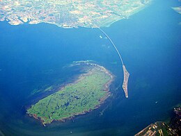
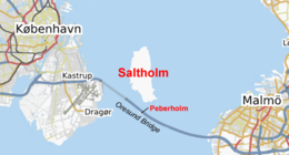
Saltholm (Danish pronunciation:[sæltˈhʌlˀm]; Salt Islet) is a Danish island in the Øresund, the strait that separates Denmark and Sweden. It is located to the east of the Danish island of Amager in Tårnby municipality and lies just to the west of the sea border between Denmark and Sweden. The island is 7 km long and 3 km across at its widest point. With an area of 16 km2, it is Denmark's 21st largest island. Saltholm is very flat; its highest point stands only 2 m (6 ft) above sea level, rendering it vulnerable to flooding if persistent east winds cause a tidal surge in the Baltic Sea.[1] It is a relatively new landmass in geological terms, having risen from the sea about 4,000 years ago due to post-glacial rebound, and is surrounded by a large area of shallow water (of 2 m depth or less) that covers an area of 28 km2 (11 sq mi). A series of islets, inlets and rock deposits from the last ice age appear at the south end of the island.[2]
Saltholm Ponds
Its neighboring island to the south is the artificial island Peberholm (Pepper Islet), which is a part of the Øresund Bridge and was named to complement Saltholm. Sometimes, Saltholm and its neighboring island to the north, Ven, are referred to as the Øresund Islands.
^Aage Aagesen, Niels Nielsen, Kongelige Danske geografiske selskab, Atlas over Danmark, p. 117. H. Hagerup, 1992
^"Saltholm". The Sound Water Cooperation. Øresundsvandsamarbejdet. Retrieved 14 January 2009.
Saltholm (Danish pronunciation: [sæltˈhʌlˀm]; Salt Islet) is a Danish island in the Øresund, the strait that separates Denmark and Sweden. It is located...
Peberholm lies approximately 1 km south of the larger natural island of Saltholm (Salt Islet) and was named to complement it. It has an area of 1.3 km2...
Taastrup - 50.686 Tårnby (a very large area of western Amager and the Saltholm (2 inhabitants (2020)) and Peberholm (nature habitat) islands are unpopulated)...
Battle of Saltholm was fought on 9 June 1808 during the Gunboat War. Danish and Norwegian ships attacked a British convoy off the island of Saltholm in Øresund...
was not expanded further. A new large airport located at the island of Saltholm (with a connecting bridge to Denmark and Sweden) was on the drawing board...
Øresund. The trench is located on the Danish side of the Øresund, between Saltholm and Amager. The road and railway connection between Denmark and Sweden...
Copenhagen and Saltholm. The island and fort are simply known as Flakfortet; the name of the island; Saltholmrev, meaning the reef near Saltholm, is seldom...
another one between Scania and the Danish isles along the Sound, with Saltholm as the central quarantine station. "Plague houses" to quarantine infected...
Skull Islet, in British Columbia, Canada Star Keys/Motuhope, New Zealand Saltholm, small Islet in Oresund west of Copenhagen Sue Islet (Queensland) Sumbiarholmur...
connecting it with the artificial island Peberholm just south of the island of Saltholm. The land area of east Denmark (east of the Great Belt) is approximately...
C.E. (2011). "Etablering og udvikling af ynglebestanden af Bramgås på Saltholm, 1992-2010". Dansk Orn. Foren. Tidsskr. 105: 159–166. "Bramgås". Danish...
boats attacked a British convoy of 70 merchant ships off the island of Saltholm in Øresund Strait near Copenhagen. The Dano-Norwegian flotilla was able...
Lomma. The lime, a key ingredient in cement, was sourced in part from Saltholm. Brick and mortar production were seasonal work and at most 350 people...
(33 ft) deep. On 19 August 1915, HMS E13 was stranded in The Sound near Saltholm. In a breach of Danish neutrality, she was destroyed by German torpedo...
 Global Information