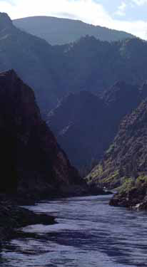
The Salmon River Mountains are a major mountain range covering most of the central part of the U.S. state of Idaho. The range is over 120 miles (190 km) long and its boundaries are usually defined by the Salmon River and its large tributary forks. Part of the central Rocky Mountains, the entire range lies west of the Continental Divide of the Americas and drains to the Snake River. The highest peak is White Mountain, at 10,442 feet (3,183 m) above sea level. There are five peaks over 10,000 feet (3,000 m) high, and there are three major subranges defined by other forks of the Salmon River: the West, Central and East Salmon River Mountains.
The mountains are an extensive block-shaped massif in central Idaho, with their western boundary defined by the Little Salmon River and the northern and eastern boundary marked by the main stem Salmon. It is a block-shaped region 102 miles (164 km) north-south and 122 miles (196 km) east-west, covering nearly 8,900 square miles (23,000 km2). The West Salmon River Mountains lie between the Little and South Forks of the Salmon, the Central range is between the South and Middle Forks, and the East range is defined by the mountains east of the Middle Fork of the Salmon. Although the northwestern corner of the range is only about 30 miles (48 km) southeast of the river port of Lewiston, the Salmon River Mountains are often said to be one of the remotest areas in the contiguous United States.[1]
The southeastern portion of the range is bounded by the White Knob Mountains, Pioneer Mountains, Bould Mountains, and the basins of Marsh Creek, Valley Creek and Warm Spring Creek. The southwestern boundaries are formed by forks of the Payette River, also a Snake River tributary.[2] The height of the mountains gradually increases from west to east, sloping up towards the Continental Divide. The highest peak is West White Mountain in the eastern subrange, rising to 10,442 feet (3,183 m). The ten highest peaks are all in the eastern subrange, while the highest peak in the central mountains is Big Baldy, at 9,705 feet (2,958 m). The highest mountain in the western subrange is North Loon Mountain, at 9,322 feet (2,841 m).[3]
^"Salmon River Mountains". SummitPost. 2006-02-16. Retrieved 2009-11-10.
^"Salmon River Mountains". Geographic Names Information System. United States Geological Survey, United States Department of the Interior. 1979-06-21. Retrieved 2009-11-10.
^"Salmon River Mountains". Peakbagger. Retrieved 2009-11-10.
and 22 Related for: Salmon River Mountains information
The SalmonRiverMountains are a major mountain range covering most of the central part of the U.S. state of Idaho. The range is over 120 miles (190 km)...
from the Snake River Plain east to the Rocky Mountains and south towards the Great Basin, as well as valleys of the upper SalmonRiver. A Nez Perce name...
of the SalmonRiver is a 104-mile-long (167 km) river in central Idaho in the northwestern United States. It is a tributary to the SalmonRiver, and lies...
populated wilderness watershed in the SalmonRiverMountains. It is the second-largest tributary of the SalmonRiver, after the Middle Fork. Beginning near...
77111 The Salmon Trout River in the Huron Mountains of Marquette County is home to the "coaster" brook trout. The 20.8-mile-long (33.5 km) river flows into...
Range. The summit of White Mountain West is the highest point of the SalmonRiverMountains. The elevation of White Mountain West includes an adjustment...
Mountains, the Scott Mountains, the Trinity Mountains, the Trinity Alps, the SalmonMountains, and the northern Yolla-Bolly Mountains. They are a section...
White Mountain Peak, a peak in California, United States White Mountain (Idaho), or White Mountain West; highest peak in the SalmonRiverMountains White...
of the Snake River. Its headwaters originate in the Sawtooth and SalmonRiverMountains at elevations over 10,000 feet (3,000 m). Drainage in the watershed...
Range. The summit of White Mountain West is the highest point of the SalmonRiverMountains. The elevation of White Mountain West includes an adjustment...
Fork SalmonRiver is a 28-mile (45 km) tributary of the SalmonRiver in Custer County, Idaho in the United States. It originates in the SalmonRiver Mountains...
collectively the Bitterroot Mountains (Salish: čkʷlkʷqin), is the largest portion of the Bitterroot Range, part of the Rocky Mountains and Idaho Batholith, located...
(Tukkutikka, Dukundeka), Sheep Eaters, Mountain Sheep Eaters, living along the SalmonRiver, SalmonRiverMountains, in the Sawtooth Valley surrounded by...
Salmon River, SalmonRiverMountains, in the Sawtooth Valley surrounded by the Sawtooth Range, upper Payette River, in the Bitterroot Mountains and Beaverhead...
The Lost River Range is a high mountain range of the Rocky Mountains, located in Central Idaho, in the Northwestern United States. It runs southeast for...
Idaho portal Mountains portal Bitterroot National Forest List of mountain ranges in Montana List of mountain peaks of Idaho "Albion Mountains". Geographic...
The SalmonRiver Falls is a 110-foot (34 m) waterfall on the SalmonRiver in Oswego County, New York in the United States. It is located approximately...
river in the Pacific Northwest region of North America. The river forms in the Rocky Mountains of British Columbia, Canada. It flows northwest and then south...
The Little SalmonRiver is a tributary of the SalmonRiver in Idaho in the western United States. The river is approximately 51 miles (82 km) in length...
 Global Information