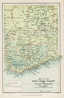
The Salaga Area (here marked as "Neutral Territory" ) in the northeast Gold Coast in 1896
The Salaga Area (German: Salaga-Gebiet) was the name of a disputed territory between the colonial powers Germany and Britain in the late 19th century, around the town of Salaga in today's northeast Ghana. Between 1889 and 1899, both powers considered the territory between their colonies of Togoland (Germany) and Gold Coast (UK), which was largely identical with the Kingdom of Dagomba, as neutral.[1][2]
In the course of the Tripartite Convention (1899) the area was split between German Togoland and the British Gold Coast. The Tripartite Convention mainly regulated the colonial division of the Pacific islands of Samoa, but the 5th of 6 articles of the Treaty regulated the distribution of Salaga. Following the defeat of Germany in World War I, France and Britain divided Togoland in 1919, and the whole of Salaga Area eventually came under British rule, and thus finally became part of the newly independent state of Ghana in 1957.
^Peter Sebald (ed.): Valentin Massow: Die Eroberung von Nordtogo 1896–1899: Tagebücher und Briefe, Bremen 2014, p. 58.
^Ayesha Harruna Attah: The Hundred Wells of Salaga – A Novel, New York City (New York) 2019, p. 229.
The SalagaArea (German: Salaga-Gebiet) was the name of a disputed territory between the colonial powers Germany and Britain in the late 19th century...
Salaga is a town and is the capital of East Gonja district, a district in the Savannah Region of north Ghana. Salaga had a 2012 settlement population of...
member of parliament for the Salaga South Constituency in the Savannah Region of Ghana. She was the first woman in the Salagaarea to be elected as a member...
German West Africa (Deutsch-Westafrika) was an informal designation for the areas in West Africa that were part of the German Colonial Empire between 1884...
Ghana did not have. In 1888, Dagbon became part of a neutral zone called SalagaArea, stretching from Yeji to Yendi, that was established to forestall conflict...
in the Northern Region of Ghana. It is located on the Tamale- Yendi or Salaga road, few meters after the Tamale Teaching Hospital. Viting is one of the...
Daboya/Mankarigu, Salaga North, Salaga South, Sawla/Tuna/Kalba and Yapei/Kusawgu. The capital of Bole district is Bole; East Gonja municipal is Salaga; West Gonja...
Koodalasangama area of Ilakal Ganjihala in Hunagunda taluk of Bagalkote district. Charan Raj who worked along with the technicians in Tagaru and Salaga extended...
The 1892 Sack of Salaga was a Gonja civil war for the control of the town of Salaga that occurred on December 5, 1892. A rebellion led by Kabachewura Isifa...
just 2 km from Salaga, the administrative capital of the district. The town serves as the traditional capital for the Kpembe Traditional Area. The former...
represent the postcode area and identify a more precise location within area. Together, the postcode district and postcode area form the postal code. For...
Salaga (leaving Kpandae at dawn, arriving in Salaga around 10 a.m., and returning in the afternoon) and one Benz bus daily between Banda and Salaga,...
Ashanti Region. The earliest bustling zongo communities in Ghana started in Salaga, and by the first quarter of the 19th century similar communities were already...
the North and parts of the Oti Region, mostly at the eastern end of the Salaga district, on the west bank of the Volta Lake/Oti River, some 70 kilometers...
wrapped around their trunks or around the roots. Similarly, two trees at Salaga in central Ghana are reminders of the slave trade. One, located at the former...
Ghana in the Northern Region, Ghana of present-day Ghana, on the road from Salaga to Bimbilla. Part of the tribe is still living there; others have migrated...
after dedicating themselves to religious studies in the Gonja metropolis of Salaga. The Zarma in Dagbon chose Hanno as their leader, and he later became the...
Finally, the mass exodus of immigrants into forest areas of Ghana following the 1892 Sack of Salaga by joint incursion by Dagomba, Namumba and Gonja tribes...
explorers who settled in both southern and northern Ghanaian locales such as Salaga, Sekondi-Takoradi, Kumasi, Accra (Jamestown, Ngleshie Alata, Tudu), Yendi...
highlighted feature and is said to extend over many miles, from Krachi to Salaga. It is so big and long that the hair can hold items in it. He has the tusks...
container ports in Africa. It has a water-enclosed area of 1.7 square kilometres (0.66 sq mi) and a total land area of 3.9 square kilometres (1.5 sq mi). Apart...
had their cola-nut supplies from the Ashantis which transported to the Salaga market. The Hausas demand in cola-nuts was high so they used to travel to...
Slaves were forced to walk about 150 km to the south to the slave market at Salaga. They are then taken to the coast for shipment. The mystery dam of Kayoro...
2072) of 2012. The Municipality has a total land area of 1,172 km2, which is 5.6 per cent of the land area of the region. It shares borders with the Republic...
 Global Information