St. Anthony Falls Historic District (ID71000438[1])
Added to NRHP
March 11, 1971
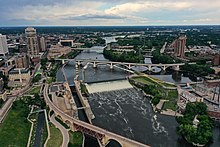
Saint Anthony Falls, or the Falls of Saint Anthony (Dakota: Owámniyomni, lit.'whirlpool'[2]), located at the northeastern edge of downtown Minneapolis, Minnesota, is the only natural major waterfall on the Mississippi River. Throughout the mid-to-late 1800s, various dams were built atop the east and west faces of the falls to support the milling industry that spurred the growth of the city of Minneapolis. In 1880, the central face of the falls was reinforced with a sloping timber apron to stop the upstream erosion of the falls. In the 1950s, the apron was rebuilt with concrete, which makes up the most visible portion of the falls today. A series of locks were constructed in the 1950s and 1960s to extend navigation to points upstream.[3]
The falls were renamed from their Dakota title in 1680 by Father Louis Hennepin after his patron saint, St. Anthony of Padua. The towns of St. Anthony[4] and Minneapolis, which had developed on the east and west sides of the falls, respectively, merged in 1872 to fully use the power of the falls for milling operations. From 1880 to about 1930, Minneapolis was known as the "Flour Milling Capital of the World".[5]
Stereoscopic photograph of the falls by Benjamin Franklin UptonIn winter
Today, the falls are defined by the spillway, the upper dam and the locks, located just downstream of the 3rd Avenue Bridge, and the Lower Lock and Dam, just upstream of the I-35W Saint Anthony Falls Bridge.[6] These locks were built as part of the Upper Mississippi River 9-Foot Navigation Project. The area around the falls is designated the St. Anthony Falls Historic District[7] and features a 1.8-mile (2.9 km) self-guided walking trail with signs explaining the area's past.
^"National Register Information System". National Register of Historic Places. National Park Service. March 15, 2006.
^Westerman, Gwen; White, Bruce (2012). Mni Sota Makoce: The Land of the Dakota. Minnesota Historical Society Press. ISBN 9780873518833.
^"St. Paul District > Missions > Navigation > Locks & Dams > Upper St. Anthony Falls". www.mvp.usace.army.mil.
^Not to be confused with the modern St. Anthony Village - "St. Anthony History". Saint Anthony Village. Retrieved April 9, 2024.
^"Mill City Museum History of St Anthony". Mill City Museum. 2005. Archived from the original on May 13, 2007.
^"St. Paul District > Missions > Navigation > Locks & Dams > Lower St. Anthony Falls". www.mvp.usace.army.mil.
^"St. Anthony Falls Historic District". City of Minneapolis. 2006.
and 20 Related for: Saint Anthony Falls information
SaintAnthonyFalls, or the Falls of SaintAnthony (Dakota: Owámniyomni, lit. 'whirlpool'), located at the northeastern edge of downtown Minneapolis, Minnesota...
The SaintAnthonyFalls Laboratory (former name: SaintAnthonyFalls Hydraulic Laboratory), or SAFL, is a research laboratory situated on Hennepin Island...
They used SaintAnthonyFalls to power sawmills in the area that became Minneapolis, while others settled downriver in the area that became Saint Paul. Minnesota's...
SaintAnthony Main is an stretch of buildings on Main Street across from SaintAnthonyFalls in the Nicollet Island/East Bank neighborhood of Minneapolis...
sections: The headwaters, 493 miles (793 km) from the source to SaintAnthonyFalls in Minneapolis, Minnesota; and A navigable channel, formed by a series...
retail stores. Founded on the banks of the Mississippi River at SaintAnthonyFalls in Minneapolis, the company originally gained fame for being a large...
review and project delivery. The report also noted that the I-35W SaintAnthonyFalls Bridge that replaced the I-35W Mississippi River bridge was completed...
flour milling and the other industries that used hydropower from SaintAnthonyFalls. The mill complex that the museum is within, dates from the 1870s...
visited North America, providing early descriptions of Niagara Falls and the SaintAnthonyFalls. The geographer Brian J. Hudson argues that it was uncommon...
using the falls for waterpower. When land became available for settlement, two towns were founded on either side of the falls: SaintAnthony, on the east...
European colonization and settlement began north of Fort Snelling along SaintAnthonyFalls—the only natural waterfall on the Mississippi River. The city's early...
1819 and 1825. Its soldiers built a grist mill and a sawmill at SaintAnthonyFalls, which were harbingers of the water-powered industries around which...
Minneapolis, Minnesota, United States, standing on the west side of SaintAnthonyFalls on the Mississippi River and running from 3rd Ave. S. to about 9th...
furnaces (e.g. the Dyfi Furnace) and gristmills, such as those built at SaintAnthonyFalls, which uses the 50-foot (15 m) drop in the Mississippi River. Technological...
bridge in Minneapolis, which collapsed on August 1, 2007 The I-35W SaintAnthonyFalls Bridge, its replacement Interstate 135 in Kansas, which was designated...
Minnesota's history and culture; such as the growth of industry powered by SaintAnthonyFalls, the state's Native American heritage, the importance of industries...
 Global Information