Sahuasiray N: 1-1963 via E. ridge. Sahuasiray S: 1-1968[2]
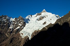
Sahuasiray[1][2][3][4][5] (possibly from Quechua sawa matrimony, siray to sew,[6]), Sawasiray,[7]Colque Cruz[1] or Ccolque Cruz[8] (possibly from Aymara and Quechua qullqi silver, money, Spanish cruz cross, "silver cross")[citation needed], is one of the highest mountains in the Urubamba mountain range in the Andes of Peru, about 5,818 metres (19,088 ft) high.[3][8] It lies in the Cusco Region, Calca Province, northwest of Calca. It is situated northeast of Chicón and Canchacanchajasa, southeast of Sirihuani and northwest of Condorhuachana.
^ abc"Peru: 22 Mountain Summits with Prominence of 1,500 meters or greater" Listed here as "Sahuasiray (Nevado Colque Cruz)" Peaklist.org. Retrieved 2013-03-02.
^ abJill Neate, Mountaineering in the Andes, 1994
^ abBiggar, John (2005). The Andes: A Guide for Climbers. Andes. p. 113. ISBN 9780953608720.
^Jenkins, Dilwyn (2005). The Rough Guide to Peru. Rough Guides. p. 158.
^Teofilo Laime Ajacopa, Diccionario Bilingüe Iskay simipi yuyayk'ancha, La Paz, 2007 (Quechua-Spanish dictionary): sawa. s. Matrimonio. Casamiento, nupcias.siray. tr. Coser. Unir mediante puntadas.
^Gade, Daniel (2015). Spell of the Urubamba: Anthropogeographical Essays on an Andean Valley in Space and Time. Springer. p. 133. ISBN 9783319208497.
Sahuasiray (possibly from Quechua sawa matrimony, siray to sew,), Sawasiray, Colque Cruz or Ccolque Cruz (possibly from Aymara and Quechua qullqi silver...
especially to the north where two prominent mountains overlook the valley: Sahuasiray, 5,818 metres (19,088 ft) and Veronica, 5,893 metres (19,334 ft) in elevation...
situated northeast of Huamanchoque, southeast of Canchacanchajasa, south of Sahuasiray, and southwest of Ccerayoc and Condorhuachana. Around 1575, the Spaniard...
highest mountains in the range are Veronica at 5,893 metres (19,334 ft) and Sahuasiray at 5,818 metres (19,088 ft). Other mountains are listed below: Chicón...
Sirihuani, north of Cóndorhuachana and Huamanchoque and southwest of Sahuasiray. It lies in the upper part of the Cancha Cancha valley (kancha kancha)...
Province, in the districts of Calca and Lares. It is situated northwest of Sahuasiray and Canchacanchajasa mountains, and northeast of Chicón. Taken from Mountaineering...
Huiscana is situated northwest of Ccerayoc and Yanaorcco, and northeast of Sahuasiray. escale.minedu.gob.pe - UGEL map of the Calca Province (Cusco Region)...
Province, in the districts Calca and Lares. It lies immediately east of Sahuasiray (Colque Cruz) and northeast of Condorhuachana. Lares trek Mapa de peligros...
route passes by. It is situated south of Canchacanchajasa, southwest of Sahuasiray and Cóndorhuachana, and north of a lower peak named Cóndorhuachana. One...
appearance of the Inca Empire. This author mentions the Guallas, the Sahuasiray and the Antasayas as the oldest settlers; while the Alcavistas, Copalimaytas...
 Global Information