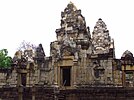
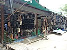
(Clockwise from top left) Lalu, Prasat Sdok Kok Thom, Locomotive at Aranyaprathet railway station, Boot shops in Rong Kluea border market, Ban Klong Luk Border railway station next to Rong Kluea market
Flag
Seal
Motto(s):
ชายแดนเบื้องบูรพา ป่างามน้ำตกสวย มากด้วยรอยอารยธรรมโบราณ ย่านการค้าไทย-เขมร ("The Eastern border. Beautiful forests and waterfalls. Rich in ancient history. The Thai-Khmer commercial area.")
Map of Thailand highlighting Sa Kaeo province
Country
Thailand
Capital
Sa Kaeo
Government
• Governor
Parinya Phothisat (since October 2021)
Area
[1]
• Total
7,195 km2 (2,778 sq mi)
• Rank
Ranked 27th
Population
(2018)[2]
• Total
564,092
• Rank
Ranked 45th
• Density
78/km2 (200/sq mi)
• Rank
Ranked 64th
Human Achievement Index
[3]
• HAI (2022)
0.6207 "low" Ranked 66th
GDP
[4]
• Total
baht 45 billion (US$1.6 billion) (2019)
Time zone
UTC+7 (ICT)
Postal code
27xxx
Calling code
037
ISO 3166 code
TH-27
Website
www.sakaeo.go.th[dead link]
Sa Kaeo (Thai: สระแก้ว, pronounced[sàʔkɛ̂ːw]) is one of the 76 provinces (changwat) and lies in eastern Thailand about 200 km from Bangkok. Neighboring provinces are (from south clockwise) Chanthaburi, Chachoengsao, Prachinburi, Nakhon Ratchasima, and Buriram. To the east it borders Banteay Meanchey and Battambang of Cambodia.
^Thailand Human Development Report 2014: Advancing Human Development through ASEAN Community (Report). United Nations Development Programme (UNDP). 2014. pp. 134–135. ISBN 978-974-680-368-7. Retrieved 9 June 2022.
^"ร่ยงานสถิติจำนวนประชากรและบ้านประจำปี พ.ศ.2561" [Statistics, population and house statistics for the year 2018]. Registration Office Department of the Interior, Ministry of the Interior. stat.bora.dopa.go.th (in Thai). 31 December 2018. Archived from the original on 2 April 2019. Retrieved 20 June 2019. Archived 2 April 2019 at the Wayback Machine
^"ข้อมูลสถิติดัชนีความก้าวหน้าของคน ปี 2565 (PDF)" [Human Achievement Index Databook year 2022 (PDF)]. Office of the National Economic and Social Development Council (NESDC) (in Thai). Retrieved 12 March 2024, page 76{{cite web}}: CS1 maint: postscript (link)
^"Gross Regional and Provincial Product, 2019 Edition". <>. Office of the National Economic and Social Development Council (NESDC). July 2019. ISSN 1686-0799. Retrieved 22 January 2020.
Banteay Meanchey and Battambang of Cambodia. SaKaeo became a province in 1993, when the six districts SaKaeo, Khlong Hat, Wang Nam Yen, Aranyaprathet,...
SaKaeoprovince. As of 2005, it had a population of 16,591. The town covers 11 sub-districts (tambon). In 1979–1980 SaKaeo was the site of the Sa Kaeo...
Amphoe Mueang SaKaeo (Thai: เมืองสระแก้ว) is the capital district (amphoe mueang) of SaKaeoprovince, eastern Thailand. Neighboring districts are (from...
อรัญประเทศ, pronounced [ʔā.rān.já.prā.tʰêːt]) is a district (amphoe) in SaKaeoprovince in Thailand. It borders Cambodia to the east and the busiest border...
Peninsula, Indochina) and Thailand in East region (Chanthaburi province, SaKaeoprovince). It was formerly known as Chalcosoma caucasus, a name which is...
Thailand. Neighboring provinces are (from north clockwise) Nakhon Ratchasima, SaKaeo, Chachoengsao, and Nakhon Nayok. Located in Si Mahosot district, their...
บิณฑ์ บรรลือฤทธิ์; nickname: Top; born May 27, 1962, in SaKaeoprovince (Prachinburi province at the time) is a Thai actor and director whose notable...
Aranyaprathet (Thai: อรัญประเทศ) is a town (thesaban mueang) in SaKaeoprovince in eastern Thailand. It covers the entire tambon of Aranyaprathet, in...
pronounced [tāː pʰrā.jāː]) is the northeasternmost district (amphoe) of SaKaeoprovince, eastern Thailand. The area was originally dense forest in Aranyaprathet...
and the Lao border in Nong Khai Province, the Eastern Line, which terminates at the Cambodian border in SaKaeoProvince, and the Southern Line, which terminates...
1996. Burapha University, Sakaeo Campus, Watthana Nakhon district, SaKaeoprovince established in 1997. The university colors are gray and gold. Gray...
Nayok province's Ongkharak district. Other minor campuses include Bhodivijjalaya College’s campuses in SaKaeoprovince and Chiang Mai province’s Mae Chaem...
theft gang who stole ฿8 million in a month is arrested. 23 January – SaKaeoprovince introduces a 10 pm curfew for minors aged under 15 following the murder...
Nam Yen District, SaKaeoProvince, Thailand. It is currently used mostly for football matches and is the home stadium of SaKaeo F.C. 13°29′52″N 102°10′47″E...
eight national parks. Pang Sida National Park covering 844 km2 in SaKaeoprovince, it constitutes a part of the Dong Phayayen-Khao Yai Forest Complex...
provinces of Thailand, together with Amnat Charoen province, SaKaeoprovince, and Bueng Kan province. On 6 October 2022, a mass murder occurred at and...
pronounced [kʰlɔ̄ːŋ hàːt]) is the southeasternmost district (amphoe) of SaKaeoprovince, eastern Thailand. The area originally was a forest with plenty of...
pronounced [kʰǎw t͡ɕʰā.kān]) is a district (amphoe) in the western part of SaKaeoprovince, eastern Thailand. The district is named after the hills of Khao Chakan...
Sankamphaeng Range in SaKaeoProvince Phae Mueang Phi ("Ghost Canyon") near Phrae in the Phi Pan Nam Range Phu Phra Bat Buabok in Udon Thani Province Paşabağı, Cappadocia...
border town of Aranyaprathet. The temple is in Khok Sung District, SaKaeoProvince, near the village of Ban Nong Samet. It is regarded as the largest...
of SaKaeoprovince, eastern Thailand. Neighboring districts are (from the south clockwise) Aranyaprathet, Watthana Nakhon and Ta Phraya of SaKaeo Province...
Lalu, Nepal Lalu (ละลุ), natural rock formations caused by erosion in SaKaeoProvince, Thailand This disambiguation page lists articles associated with the...
the border with Cambodia. It is located in Aranyaprathet District, SaKaeoProvince 250 kilometers from Bangkok. There are 1380 stores, mostly with goods...
tʰā.nāː ná(ʔ).kʰɔ̄ːn]) is a district (amphoe) in the central part of SaKaeoprovince, eastern Thailand. Watthana Nakhon is an ancient city. Established...
Nong Chan Refugee Camp, in Nong Chan Village, Khok Sung District, SaKaeoProvince, Thailand, was one of the earliest organized refugee camps on the Thai-Cambodian...
 Global Information