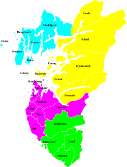
Ryfylke is a traditional district in the northeastern part of Rogaland county, Norway. The 4,546-square-kilometre (1,755 sq mi) district is located northeast of the city of Stavanger and east of the city of Haugesund and it encompasses about 60% of the county's area. It includes the mainland located northeast and east of the Boknafjorden and east of the Høgsfjorden. It also includes the islands located on the south side of the Boknafjorden. To the east, Ryfylke borders the districts of Setesdal and Sirdal, to the south is Jæren, and to the west is Haugalandet. Ryfylke is one of the 15 districts in Western Norway.[1]
Ryfylke comprises the contemporary municipalities of Sauda, Suldal, Hjelmeland, Strand, Kvitsøy, the eastern island portion of Stavanger, and the Forsand part of Sandnes. There are no large cities in Ryfylke, but there are two major towns, Sauda and Jørpeland.
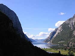
Scenic attractions include the Lysefjord with the mountain Preikestolen ("Pulpit Rock") and the mountain Kjerag. The landscape of Ryfylke is characterized by high mountains in the interior; the highest and wildest are located in the north and are formed by hard, igneous rock.[1]
At Haukalivatnet lake (near Lysefjorden) there is a distinct end moraine presumably created by a prehistoric glacier. This moraine led professor Jens Esmark (in 1824) to formulate the theory of an ice age over Scandinavia and other parts of the world. Esmark believed that climate changes due to the changes of the Earth's orbit caused ice ages.[2]
^ abStore norske leksikon. "Ryfylke" (in Norwegian). Retrieved 2016-02-10.
^Hestmark, G. (2018). Jens Esmark's mountain glacier traverse 1823− the key to his discovery of Ice Ages. Boreas, 47(1), 1-10.
Ryfylke is a traditional district in the northeastern part of Rogaland county, Norway. The 4,546-square-kilometre (1,755 sq mi) district is located northeast...
The Ryfylke Tunnel (Norwegian: Ryfylketunnelen) is an undersea road tunnel in Rogaland county, Norway. It is part of the Norwegian National Road 13 running...
most recently in 2013 when two deaneries were merged to form the new Ryfylke deanery. This arch-deanery (Norwegian: domprosti) covers the central part...
as "Preikestolen." Preikestolen is located in the southern part of the Ryfylke district in Rogaland county in Western Norway. The city of Stavanger, the...
reduced travel time between the Northern Jæren and Ryfylke districts in Rogaland county. Ryfylke officially opened to traffic at noon on 30 December...
County has a total of 23 municipalities: Boknafjord Dalane Haugaland Jæren Ryfylke Bryne Egersund Haugesund Jørpeland Kopervik Sauda Sandnes Skudeneshavn...
in the traditional district of Ryfylke. Since 1965, the administrative centre of Suldal is the village of Sand i Ryfylke (prior to that it was the village...
Lysefjord or Lysefjorden is a fjord located in the Ryfylke area in Rogaland county in southwestern Norway. The 42-kilometre (26 mi) long fjord lies in...
Ryfylke District Court (Norwegian: Ryfylke tingrett) was a district court in Rogaland county, Norway. The court was based in the city of Stavanger. The...
with motives from the coastal landscape in the traditional district of Ryfylke is regarded as one of the peaks of Norwegian painting. Lars Hertervig was...
deepest undersea tunnel, the Norwegian Ryfylke Tunnel, is 291 metres (955 ft) below sea level. A tunnel deeper than Ryfylke is under construction, also in Norway;...
(to) light) is an industrial and multi-utility company based in Jæren and Ryfylke, Norway. The company has a yearly normal production of 9.5 TWh of hydroelectric...
Stavanger lies about 25 kilometres (16 mi) southwest of Holta (via the Ryfylke Tunnel that goes under a large fjord). On 9 August 1961, the Holtaheia...
water-crossings are too long for bridges. The Ryfylke Tunnel is the country's longest, at 14,400 meters (47,200 ft). The Ryfylke Tunnel is the world's deepest, reaching...
to repair the damage. The former mine site is maintained as an annex of Ryfylke Museum. Hakanoglu, Orli (June 14, 2016). "Master of Modesty: Peter Zumthor's...
into Sandnes municipality. It was located in the traditional district of Ryfylke. The administrative centre of the municipality was the village of Forsand...
knighted by King Eric of Pomerania in 1430 and became feudal overlord of Ryfylke in Rogaland, Norway. He was a wealthy landowner with properties in both...
Commons has media related to Kjerag. Kjeragbolten - 360* Panoramic Pictures - Virtual Norge Flickr Kjerabolten Images Ryfylke - Kjerag (in Norwegian)...
Rogaland county, Norway. It is located in the traditional district of Ryfylke. The administrative centre of the municipality is the village of Hjelmelandsvågen...
Bourgeois and Swiss Peter Zumthor have designed stops in Varanger and Ryfylke. Artworks have been installed at selected viewpoints, including one by...
57.5-square-kilometre (22.2 sq mi) island is the largest island in the Ryfylke region and the second largest island in Rogaland county. There are several...
Sogndalsfjøra. In 2020, a new tunnel was opened between Stavanger and Tau, Ryfylke Tunnel, the world's deepest public road tunnel. National Road 13 was then...
Ingeborg were crowned directly after their marriage, and Magnus was given Ryfylke for his personal upkeep. On 16 December 1263 King Håkon died while fighting...
also the second-deepest transport tunnel below the sea level after the Ryfylke Tunnel, a road tunnel in Norway which opened in 2019, and the second longest...
well as to the shipping route along the western coast and the fertile Ryfylke Islands in the north. The earliest Christian impulses in Norway came to...
6.05472 Country Norway Region Western Norway County Rogaland District Ryfylke Municipality Hjelmeland Elevation 47 m (154 ft) Time zone UTC+01:00 (CET)...
According to the Heimskringla, the Battle of Soknasund occurred during 1033 in Ryfylke. Tryggve the Pretender came with an army from England. He said he was the...
 Global Information