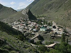
Rutulsky District (Russian: Руту́льский райо́н) is an administrative[1] and municipal[4] district (raion), one of the forty-one in the Republic of Dagestan, Russia. It is located in the south of the republic. The area of the district is 2,170 square kilometers (840 sq mi).[citation needed] Its administrative center is the rural locality (a selo) of Rutul.[1] As of the 2010 Census, the total population of the district was 22,926, with the population of Rutul accounting for 18.0% of that number.[2]
^ abcdLaw #16
^ abcRussian Federal State Statistics Service (2011). Всероссийская перепись населения 2010 года. Том 1 [2010 All-Russian Population Census, vol. 1]. Всероссийская перепись населения 2010 года [2010 All-Russia Population Census] (in Russian). Federal State Statistics Service.
^Cite error: The named reference OKATO2 was invoked but never defined (see the help page).
^ abcLaw #6
^"Об исчислении времени". Официальный интернет-портал правовой информации (in Russian). June 3, 2011. Retrieved January 19, 2019.
^Federal State Statistics Service (May 21, 2004). Численность населения России, субъектов Российской Федерации в составе федеральных округов, районов, городских поселений, сельских населённых пунктов – районных центров и сельских населённых пунктов с населением 3 тысячи и более человек [Population of Russia, Its Federal Districts, Federal Subjects, Districts, Urban Localities, Rural Localities—Administrative Centers, and Rural Localities with Population of Over 3,000] (XLS). Всероссийская перепись населения 2002 года [All-Russia Population Census of 2002] (in Russian).
^Всесоюзная перепись населения 1989 г. Численность наличного населения союзных и автономных республик, автономных областей и округов, краёв, областей, районов, городских поселений и сёл-райцентров [All Union Population Census of 1989: Present Population of Union and Autonomous Republics, Autonomous Oblasts and Okrugs, Krais, Oblasts, Districts, Urban Settlements, and Villages Serving as District Administrative Centers]. Всесоюзная перепись населения 1989 года [All-Union Population Census of 1989] (in Russian). Институт демографии Национального исследовательского университета: Высшая школа экономики [Institute of Demography at the National Research University: Higher School of Economics]. 1989 – via Demoscope Weekly.
^Всесоюзная перепись населения 1979 г. Национальный состав населения по регионам России [All Union Population Census of 1979. Ethnic composition of the population by regions of Russia] (XLS). Всесоюзная перепись населения 1979 года [All-Union Population Census of 1979] (in Russian). 1979 – via Demoscope Weekly (website of the Institute of Demographics of the State University—Higher School of Economics.
RutulskyDistrict (Russian: Руту́льский райо́н) is an administrative and municipal district (raion), one of the forty-one in the Republic of Dagestan...
husbandry), farming, and gardening. Most of the Rutulians live in the RutulskyDistrict of Dagestan. According to the 2010 census, 35,240 Rutulians lived...
less than 2%. In Dagestan, they live in the mountainous parts of the Rutulskydistrict. According to Wolfgang Schulze, there are 9 villages in Azerbaijan...
District and RutulskyDistrict) and contiguous northeastern Azerbaijan (in Kuba, Qusar, Qakh, Khachmaz, Oguz, Qabala, Nukha, and Ismailli districts). The Lezgin...
begins north of the mountains in the upper reaches of the Samur River (RutulskyDistrict) with the Tsakhur people – a western branch of the Lezgians. They...
(RutulskyDistrict), Azerbaijan (Zagatala and Qakh districts) Islam → Sunni Islam Tsez Northeast Caucasian → Tsezic → Tsez Russia (Tsuntinsky District)...
information Full name Milad Valerikovich Alirzaev Nationality Russia Born RutulskyDistrict, Dagestan, Russia Weight 87 kg (192 lb) Sport Country Russia Sport...
Greater Caucasus. The mountain belongs to the Samur basin. It is in RutulskyDistrict, 5 km north of the village Borch and 9 km southwest of the larger...
Levashinsky District Magaramkentsky District Nogaysky DistrictRutulskyDistrict Sergokalinsky District Shamilsky District Tabasaransky District Tarumovsky...
selo) and the administrative centre of Luchekskoye Rural Settlement, RutulskyDistrict, Republic of Dagestan, Russia. Population: 758 (2002 Census); . Luchek...
This is a list of districts of Russia. A district (raion) is an administrative and municipal division of a federal subject of Russia. Within the framework...
Микик) is a rural locality (a selo) in Tsakhurskoye Rural Settlement, RutulskyDistrict, Republic of Dagestan, Russia. Population: 532 (2010 Russian census);...
the south of the republic and borders with Rutulsky, Kurakhsky, Magaramkentsky, and Dokuzparinsky Districts; in the southwest it has a 62-kilometer (39 mi)...
Хиях) is a rural locality (a selo) in Tsakhurskoye Rural Settlement, RutulskyDistrict, Republic of Dagestan, Russia. Population: 56 (2010 Russian census);...
and the administrative centre of Myukhrekskoye Rural Settlement, RutulskyDistrict, Republic of Dagestan, Russia. Population: 743 (2010 Russian census);...
Вырыш) is a rural locality (a selo) in Luchekskoye Rural Settlement, RutulskyDistrict, Republic of Dagestan, Russia. Population: 32 (2010 Russian census);...
selo) and the administrative centre of Kalyalskoye Rural Settlement, RutulskyDistrict, Republic of Dagestan, Russia. Population: 399 (2010 Russian census);...
and the administrative centre of Gelmetsinskoye Rural Settlement, RutulskyDistrict, Republic of Dagestan, Russia. Population: 609 (2010 Russian census);...
selo) and the administrative centre of Ikhrekskoye Rural Settlement, RutulskyDistrict, Republic of Dagestan, Russia. Population: 2,050 (2010 Russian census);...
 Global Information