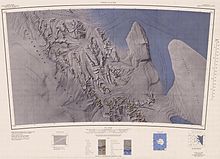
Radarsat image of ice streams, including the Rutford, flowing into the Filchner-Ronne Ice ShelfMap of Northern Sentinel Range and upper Rutford Ice Stream.Map of Sentinel Range and Rutford Ice Stream.Map of Heritage Range and lower Rutford Ice Stream.
Rutford Ice Stream (79°00′S81°00′W / 79.000°S 81.000°W / -79.000; -81.000) is a major Antarctic ice stream, about 290 kilometres (180 mi) long and over 24 kilometres (15 mi) wide, which drains southeastward between the Sentinel Range, Ellsworth Mountains and Fletcher Ice Rise into the southwest part of Ronne Ice Shelf. Named by US-ACAN for geologist Robert Hoxie Rutford, a member of several USARP expeditions to Antarctica; leader of the University of Minnesota Ellsworth Mountains Party, 1963-1964. Rutford served as Director of the Division of Polar Programs, National Science Foundation, 1975-1977.[1]
The ice stream is situated in a deep trough which is a tectonic feature between the Ellsworth Mountains and the Fletcher Promontory. Because of this the ice stream position may have been stable for millions of years. The bed of the ice stream reaches 2,000 metres (6,600 ft) below sea level. Therefore, between the bed of the ice stream and the height of the Ellsworth Mountains there is a vertical relief of 7 kilometres (4.3 mi) over a distance of only 40 kilometres (25 mi).[2] At the upper (inland) end of the ice stream the ice thickness reaches 3,100 metres (10,200 ft) falling to around 2,300 metres (7,500 ft) in the trough. Flow speed reaches a maximum of around 400 metres (1,300 ft) per year about 40 kilometres (25 mi) inland from where the ice stream meets the Ronne Ice Shelf and starts to float on the sea.[2]
The speed of the Rutford ice stream varies by as much as 20% every two weeks, in response to variations in the tides.[3]
^"Rutford Ice Stream". Geographic Names Information System. United States Geological Survey. Retrieved 6 November 2009.
^ abDoake, C.; H. Corr; A. Jenkins; K. Makinson; K. Nichalls; C. Nath; A. Smith & D. Vaughan (2001). "Rutford Ice Stream, Antarctica". In Alley, Richard & Bindschadler, Robert (eds.). The West Antarctic Ice Sheet: Behaviour and Environment. American Geophysical Union. pp. 221–235. ISBN 0-87590-957-4.
Crosswell Glacier to the east. The Crosswell Glacier flows into the RutfordIceStream via Ellen Glacier. The south face of Mount Vinson is drained by Roché...
Seismic evidence for a water-filled canal in deforming till beneath RutfordIceStream, West Antarctica. Geophys. Lett. 31 (2004). "Types of Volcanoes"....
the valley, south of Kostinbrod Pass. The valley ice flows southeastwards towards the RutfordIceStream. The feature is named after the medieval fortress...
of the Ronne Ice Shelf, Antarctica. The feature is completely ice covered and rises between RutfordIceStream and Carlson Inlet. The ice rise was observed...
east side of Sentinel Range in Ellsworth Mountains. It surmounts RutfordIceStream to the east and the ends of its tributaries flowing from Sikera Valley...
The glacier flows eastwards into RutfordIceStream. The glacier is named after Vit River in Northern Bulgaria. Vit Ice Piedmont is centred at 77°54′00″S...
Ellsworth Mountains, Antarctica. It surmounts Yamen Glacier to the north, RutfordIceStream to the east and Vicha Glacier to the southwest. The peak is named...
It is draining the northeast slopes of Flowers Hills to flow into RutfordIceStream to the east-northeast and Ellen Glacier to the north. The feature...
northern Sentinel Range in Ellsworth Mountains, Antarctica. It surmounts RutfordIceStream to the east and lower Vicha Glacier to the west. The feature is named...
overlooking Carey Glacier to the west, Divdyadovo Glacier to the north, and RutfordIceStream to the east. The peak is named after the Bulgarian cartographer Aleksandar...
northern Sentinel Range in Ellsworth Mountains, Antarctica. It surmounts RutfordIceStream to the east and the head of Vicha Glacier to the southwest. The mountain...
south and west, Embree Glacier and Kopsis Glacier to the north, and RutfordIceStream and Arapya Glacier to the east, and linked to Bangey Heights to the...
opened in 1978. Robert H. Rutford, an Antarctic explorer recognized with the naming of the RutfordIceStream and Mount Rutford in Antarctica, became the...
forms the southeastern extremity of the Doyran Heights, and overlooks RutfordIceStream to the east and Obelya Glacier to the west. The feature was first...
nourished by ice from the plateau west of the mountains and by Nimitz Glacier and Splettstoesser Glacier, and merges into the larger RutfordIceStream at the...
Antarctica. It is draining the east slopes of Barnes Ridge to flow into RutfordIceStream to the east-northeast, Young Glacier to the north, and Ellen Glacier...
Mountains, Antarctica, and overlooking Carey Glacier to the west and RutfordIceStream to the east. The peak is named after the village of Malkoch in Bulgaria...
part. It is part of the glacial divide between Nimitz Glacier and RutfordIceStream, overlooking Severinghaus Glacier to the southwest and Saltzman Glacier...
the Vinson Massif between Sullivan Heights and Veregava Ridge to RutfordIceStream which borders the eastern flank of the Sentinel Range, Ellsworth Mountains...
bounded by Hansen Glacier and Dater Glacier to the west and north, RutfordIceStream to the east and Sikera Valley to the southwest, and separated from...
Ice Shelf, to the Northeast by Coats Land, to the East by Queen Maud Land, and extends in the West to a line between the South Pole and RutfordIce Stream...
marked by the extensive Miller Bluffs. The heights are bounded by RutfordIceStream to the east and Newcomer Glacier to the south and west, and is connected...
north-northeastwards and north of Mount Schmid turning east to join RutfordIceStream east of Mount Tegge. Named by the US-ACAN for Maj. Henry Embree, USAF...
 Global Information