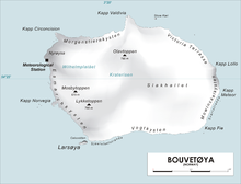
Rustad Knoll (54°28′S3°23′E / 54.467°S 3.383°E / -54.467; 3.383) is a rounded, snow-topped elevation (365 m) which surmounts the south shore of the island of Bouvetøya immediately east of Cato Point. First charted in 1898 by a German expedition under Carl Chun.[1] The knoll was recharted in December 1927 by the Norvegia expedition under Captain Harald Horntvedt.[2] They named it for Ditlef Rustad who was in charge of the biological research of the expedition.[3]
^"Prof. Dr. phil., Dr. med. h. c. Carl Chun". University of Leipzig. Retrieved October 1, 2016.
^"Norvegia I". polarhistorie.no. Retrieved October 1, 2016.
^"Norvegia-ekspedisjonene". Store norske leksikon. Retrieved October 1, 2016.
RustadKnoll (54°28′S 3°23′E / 54.467°S 3.383°E / -54.467; 3.383) is a rounded, snow-topped elevation (365 m) which surmounts the south shore of the...
southwest side of Annenkov Island, off the south coast of South Georgia RustadKnoll, rounded, snow-topped elevation (365 m) which surmounts the south shore...
1926–30. East of this point, Rustad Bay indents the island's southwest coast. It was named for Norwegian biologist Ditlef Rustad. West of the point, Horror...
School and founder of the Berkman Center for Internet & Society Michael Rustad, intellectual property scholar, author, and professor at Suffolk University...
 Global Information