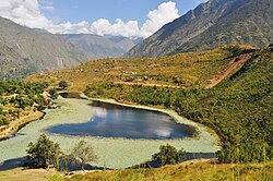
ChurjhariRukumk (Nepali: रुकुमकोट) is a town in a valley of the Eastern Rukum District in Nepal. Nearby is a pond called Rukmini Tal (local name: Kamal Dhaha; Nepali: कमलदह). There is an historic Shibalaya temple nearby. Other temples include the Barah, Baraji, and Bhagwati temples.
The nickname of Rukum, "Baunna Pokhari Tripanna Takuri" (Place of 52 Lakes and 53 Hills), is derived from the name Rukumkot. It is believed that there are 52 ponds and lakes and 53 hills in Rukumkot.
A road was built to Rukumkot with the help of India. Another road is now being developed in the middle part of Rukumkot.
Shibalaya, a temple to Shiva on the northern shore of Rukmini Taal, was built by Purna Kumari, the wife of a Prime Minister of the Rana Dynasty. It is said that this temple is the only monument made during the Rana reign in the mid-western part of Nepal.
There is a cave in the eastern part of Rukumkot, on the bank of the Rumgad River, called Deurali Gufa. It can only be visited by walking for one hour from Rukumkot.
Climate data for Rukumkot, elevation 1,560 m (5,120 ft)
Month
Jan
Feb
Mar
Apr
May
Jun
Jul
Aug
Sep
Oct
Nov
Dec
Year
Mean daily maximum °C (°F)
14.4 (57.9)
16.0 (60.8)
20.4 (68.7)
26.4 (79.5)
27.7 (81.9)
26.6 (79.9)
24.8 (76.6)
25.0 (77.0)
24.2 (75.6)
22.9 (73.2)
19.1 (66.4)
15.9 (60.6)
22.0 (71.5)
Mean daily minimum °C (°F)
3.3 (37.9)
4.5 (40.1)
8.4 (47.1)
12.9 (55.2)
15.2 (59.4)
17.1 (62.8)
17.6 (63.7)
17.3 (63.1)
16.2 (61.2)
12.9 (55.2)
7.1 (44.8)
3.8 (38.8)
11.4 (52.4)
Average precipitation mm (inches)
37.2 (1.46)
50.9 (2.00)
48.5 (1.91)
66.7 (2.63)
158.0 (6.22)
402.7 (15.85)
653.4 (25.72)
627.2 (24.69)
270.6 (10.65)
73.8 (2.91)
25.4 (1.00)
15.9 (0.63)
2,430.3 (95.67)
Source 1: Australian National University[3]
Source 2: Japan International Cooperation Agency (precipitation)[4]
^"National Population and Housing Census 2011(Village Development Committee/Municipality)" (PDF). Government of Nepal. National Planning Commission. November 2012.
^"Postal Code, Zip Code". Archived from the original on 2014-07-01. Retrieved 2014-06-26.
^"CLIMATES OF NEPAL AND THEIR IMPLICATIONS FOR AGRICULTURAL DEVELOPMENT" (PDF). Australian National University. Archived from the original (PDF) on 23 October 2023. Retrieved 6 June 2024.
^"ネパール国 全国貯水式水力発電所マスタープラン調査 ファイナルレポート" (PDF). Japan International Cooperation Agency. Archived from the original (PDF) on 6 April 2024. Retrieved 6 June 2024.
derived from the name Rukumkot. It is believed that there are 52 ponds and lakes and 53 hills in Rukumkot. A road was built to Rukumkot with the help of India...
Rukumkot Kingdom. The new kingdom was named Gajulkot. These 18 villages were given to Tuthansen in dowry by Jayant Berma who was the king of Rukumkot...
summit ridge in May 2013. Rukumkot, a prominent village in Rukum is referred to as "the place of 52 lakes and 53 hills". Rukumkot (Nepali: all of them Shyarpu...
Airlines operated routes to Kathmandu and Nepalgunj. Airport information for Rukumkot, Nepal (VNCJ / RUK) at Great Circle Mapper. "Rukum Chaurjahari Airport"...
nepalriverrunner.com. Retrieved 10 January 2019. "Sani Bheri River, Rukumkot (Western Face of Rukumkot)". np.geoview.info. Retrieved 10 January 2019. "Bheri River...
married Kumar Mohan Bahadur Shahi, a descendant of the ruling families of Rukumkot, Jumla and Jajarkot. On June 1, 2001, ten members of the Nepalese royal...
Lake कमल ताल (Nepali) View of Kamal lake Kamal lake (Lotus Lake) Location Rukumkot,Rukum,Nepal Coordinates 28°36′51″N 82°37′32″E / 28.61417°N 82.62556°E...
जिल्ला Liwang 1,879 224,506 [59] Eastern Rukum District पूर्वी रूकुम जिल्ला Rukumkot 1,161 56,786 [60] Banke District बाँके जिल्ला Nepalganj 2,337 603,194 [61]...
जिल्ला Liwang 1,879 224,506 [9] Eastern Rukum District पूर्वी रूकुम जिल्ला Rukumkot 1,161.13 53,018 [10] Banke District बाँके जिल्ला Nepalganj 2,337 491,313...
crash 1978 April 7 Short SC.7 Skyvan Variant Royal Nepalese Air Force Rukumkot, Rapti 0 1981 November 19 Pilatus PC-6 Turbo Porter Royal Nepal Airlines...
of Rapti zone were Pyuthan Khalanga, Bijuwar, Liwang, Lamahi, Musikot, Rukumkot (Shova), and Chaurjahari. Rapti was divided into five districts; since...
जिल्ला Liwang 1,879 224,506 [9] Eastern Rukum District पूर्वी रूकुम जिल्ला Rukumkot 1,161.13 53,018 [10] Banke District बाँके जिल्ला Nepalganj 2,337 491,313...
Rajya Lakshmi Devi visited the birth-place of her husband in Bahunthana (Rukumkot), the name of the village was changed to "Shova." These forms of royal...
Family Population Per km2 Growth Rate 1 Eastern Rukum पूर्वी रूकुम जिल्ला Rukumkot 53184.00 11702.00 13264.00 57962.00 28226.00 29736.00 1663.00 94.92 4.37...
 Global Information